As you may recall from my last post, on our first full day in the Sawtooths we attempted to hike to Sawtooth Lake but ultimately turned around due to trail conditions. However, some research later that afternoon (when we were in town and had phone service) revealed that at its core, this had been a failure of planning.
It turns out there are multiple routes to Sawtooth Lake. The main – and shortest – departs from Iron Creek Trailhead. Instead, we’d departed from Stanley Lake on a longer, steeper, and lesser maintained route. Oops.
The next morning, it was time to try again. From the proper trailhead this time.
As soon as we arrived, it became clear that we’d missed multiple fairly obvious signs the day before. For starters, this time there were many cars parked at the trailhead – as one would expect when one sets off on one of the most popular hikes in an area. Sawtooth Lake was on the trail signs this time too. And the path looked well-traveled.
There still weren’t any bridges on the creek crossings, but at least this time there were only two of them, and they were easily accomplished by rock-hopping.
Properly prepared this time, we filled out the mandatory free self-issue wilderness permit at the trailhead kiosk and then we were off.
The trail begins fairly gradually, gaining just 400 feet (120 m) in the first 2 miles (3.2 km). There are two junctions to navigate, but both have clear signs.

Beyond the second junction, the incline steepens a bit over the next mile to the creek crossing.

Once we were across the creek, it was time to begin climbing in earnest. Luckily, we had progressively more spectacular views to distract us from the somewhat grueling ascent. The remainder of the route climbs at a rate of about 600 feet per mile (115 m per km) to the lake.


A little less than a mile (1.6 km) after the creek crossing is the turnoff to Alpine Lake. I don’t recall if there was a trail sign here, but the route was clearly marked on my maps app.
It’s not a long walk, and pretty soon we were at the shore of this small, clear lake nestled in a deep bowl at the base of Alpine Peak.


We enjoyed a snack on an outcrop near the shore and might have stayed a few minutes longer if not for the mosquitoes.
Back on the main trail, we still had about 1 mile (1.6 km) to go to reach Sawtooth Lake. Slow and steady was the name of the game as we zigzagged our way up the switchbacks above Alpine Lake.

Once we reached the top of the switchbacks, a jagged mountain ridgeline came into view – one of many that (presumably) give the Sawtooth Mountains their name.

We hiked this trail in late June and, despite the drought plaguing the western US, Idaho received quite a lot of late spring snow this year. About 0.5 miles (0.8 km) below the lake, we caught up to it. With hiking poles, though, it was easy to navigate.


Right: a series of fallen trees along the trail, followed by yet another patch of snow
At last, we reached the high point of the hike. From here, it was just a short and slightly downhill walk back to Sawtooth Lake. We came first to a small pond, giving us just a glimpse of the splendor that awaited us.

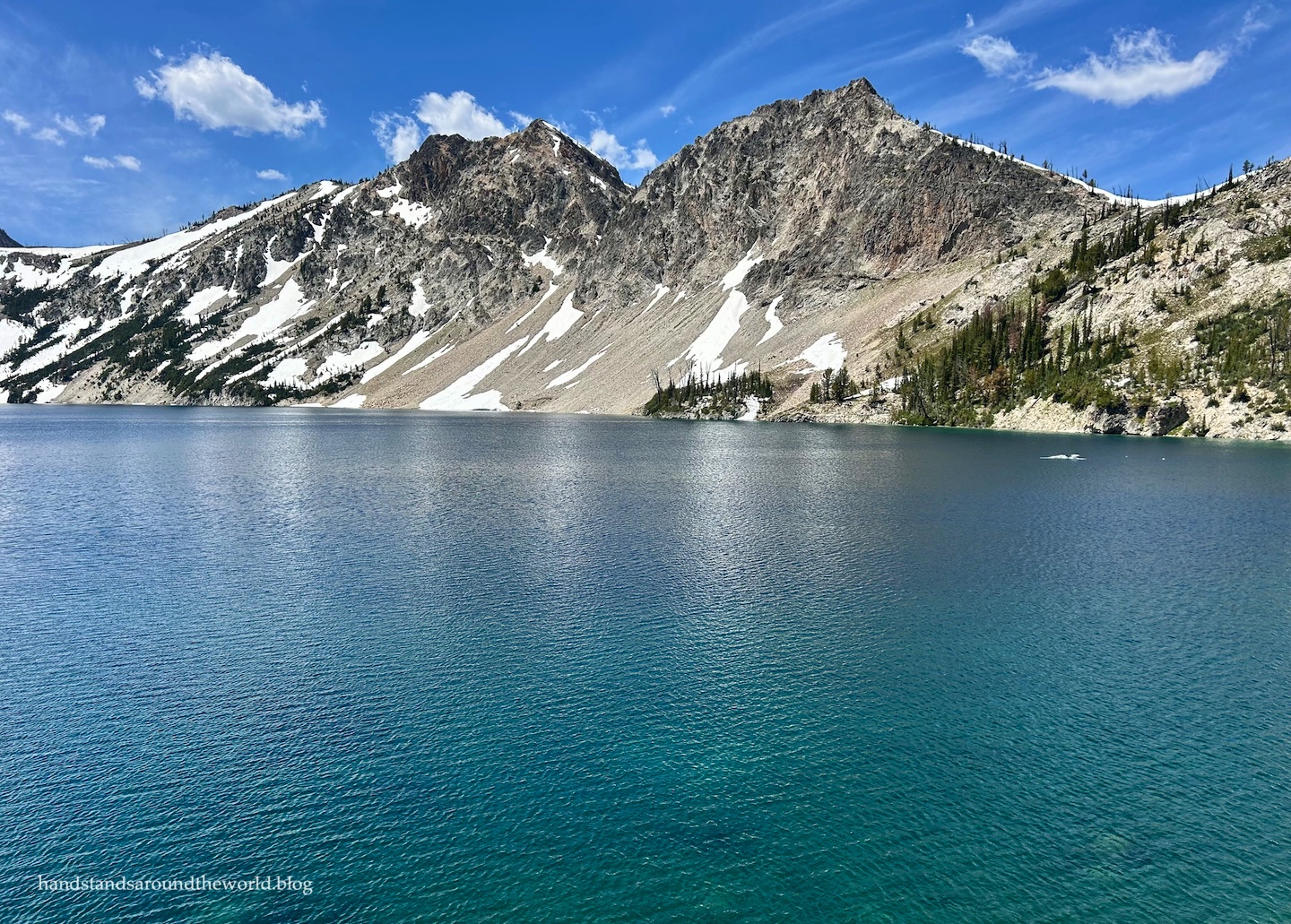
Finally, just over three hours after departing the trailhead, we reached Sawtooth Lake.
All I can say is wow.

The mountains are stunning. The water is crystal clear. Lingering snow and gnarled bristlecone pines line the shore. I’m so glad we found the correct trail and made it to the lake, because missing out on this hike would have been a huge bummer.


Sawtooth Lake is the largest lake in the Sawtooths; so large that it’s difficult to actually see all of it at once. In fact, this first glimpse was of maybe one-quarter of the lake. To see more, you have to be willing to hike partway around to your left (south) or climb the hill to your right (north).
We did both, heading right first. There’s not an official route, but social trails lead along the shore and up to a vantage point. We just had to claw our way through a fallen tree first.


After eating some lunch and enjoying the view from this high point, we made our way back down – this time finding a route that went behind the tree instead of through it – and then rock-hopped across the creek and headed south. This section of trail was completely snow-covered still, but once we made it around to the other side of the small peninsula the ground was visible once more, as was the rest of the lake.


In total, we spent an hour at the lake and easily could have spent more. However, we had a nearly 5 mile (8 km) hike back to the car, which meant it was time to head out. Lucky for us, we still had quite a few nice views to enjoy as we made our way back across the snow and down the switchbacks.


And then it was back across the creek and into the trees for the remainder of the hike. By the time we reached the last mile, our legs were very ready to be done and our feet were very excited to no longer be crammed into hiking boots. And with the forest all around us, we no longer had expansive views as a distraction.
We headed into town afterwards for some well-earned ice cream by the Salmon River, and then returned to our campsite for the night.

This was by far the most difficult hike of our trip, but also our favorite. In fact, it’s high on my list of the best hikes I’ve ever done. It’s a hike I will happily repeat someday in the future when I return to the Sawtooths with my husband.
But that’s a hypothetical trip that’s still likely a few years in the future. For now, my mom and I still had a few more days of exploration in Idaho. More on that in my next post.
For now, I leave you with my most scenic handstand of the trip.

Up next: fossils and waterfalls of southern Idaho
The Important Stuff:
- Getting there: the main and best way to reach Sawtooth Lake is to begin at Iron Creek Trailhead, located at the end of Road 619 outside Stanley, Idaho. It’s a dirt road but in very good condition; any car can make it when the road is dry.
- Fees and passes: none, but a self-issue permit must be completed at the trailhead before beginning your hike.
- Hiking: roundtrip distance, including the side trip to Alpine Lake, is about 10.1 miles (16.3 km) with 1915 feet (585 m) of elevation gain. Sawtooth Lake sits at about 8500 feet (2590 m), so if you’re not used to the altitude, that will bump up the difficulty.
- Where to stay: the closest campground is the small first-come-first-serve campground at the end of Iron Creek Road. However, there are many others within a 30 minute radius, as well as hotels, cabins, and rentals in Stanley, Idaho. Backpacking is also an option along this trail, and we talked to people who had spent the night at both Alpine Lake and Sawtooth Lake.
- Other: note that there are many interconnected trails in the Sawtooths, which means there is more than one way to reach Sawtooth Lake. If you plan to hike to the lake via the Stanley Lake or Alpine Way Trails, be prepared for a much longer hike through rugged conditions, with narrow trails and challenging creek crossings.


Leave a Reply