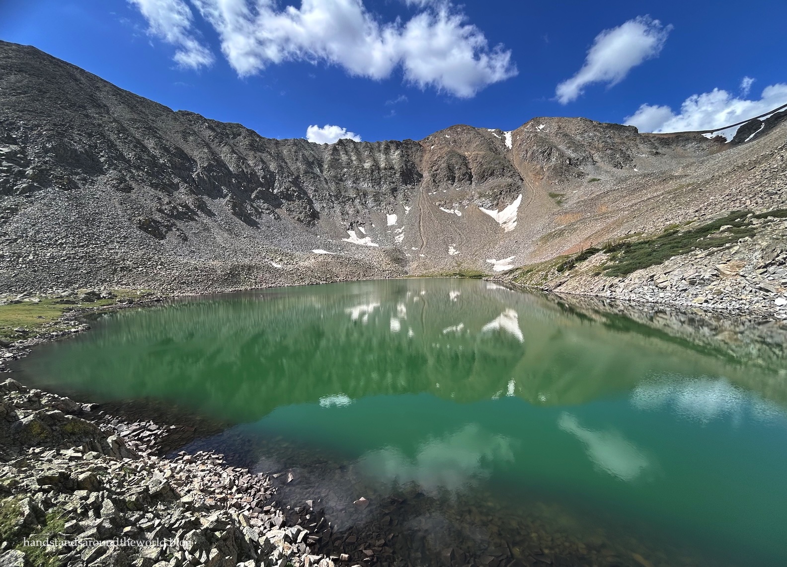
The name Lake of the Clouds captured my attention the moment I heard it. It just sounded like such a mystical place.
Add in its location, high in the rugged (and also mystically-named) Never Summer Mountains on the western edge of Rocky Mountain National Park, and I was hooked. I couldn’t wait to see it.
But wait I did. For years.
Five of them, to be precise.
As the crow flies, Lake of the Clouds is only 2.5 miles (4 km) from Trail Ridge Road in Rocky Mountain National Park. Via the very indirect trails that form a giant S shape, though, the lake is approximately 6.6 miles (10.6 km) and 2600 vertical feet (790 m) away. It’s a long day hike, made longer by the fact that the last section is a giant pile of boulders and therefore very slow going.
However, the Dutch Town backcountry site is just under 1 mile (1.6 km) and about 600 vertical feet (180 m) below the lake, making it an ideal base camp for a visit to Lake of the Clouds.
The problem? There’s only one campsite here, and it’s a highly coveted permit. We tried to get it in 2022 and were unsuccessful. We tried again in 2023 and once again didn’t get it.
Finally, in 2024, we got it!
And then the weekend of our trip rolled around, and the weather forecast was awful. Ninety percent chance of thunderstorms and heavy rain from 9:00am to 9:00pm both days. We would have been cold and wet the entire time, not to mention the fact that scrambling up a giant pile of wet boulders above tree line when there’s lightning is just plain dangerous.
With disappointment sitting heavily in my stomach, I logged into my account and canceled our permit.
When opening day for backpacking permits rolled around in 2025, it was time to enter the all-too-familiar battle once more.
We lost. Again.
Finally, in 2026, we were successful!
Apparently fifth time is the charm. That’s the saying, right?
Then, about two weeks in advance of our trip, we headed up to the park to pick up our permit… and that’s when it all came crashing down around us.
Okay, so that’s perhaps a little dramatic. We did finally make it to Lake of the Clouds, so it didn’t all come crashing down. But some of it did. And after five years of battling for this stupid backpacking permit, we didn’t even end up using it.
Why, you might ask?
Well, because when we went to pick it up, the ranger informed us that habituated marmots and some other unidentified-but-possibly-packrat rodents were wreaking havoc on the Dutch Town campsite.
All wild animals will get into poorly-stored food or other scented items. But marmots in particular will chew up anything and everything looking for salt. That includes the salt in human urine and the salt in human sweat – the latter of which is inevitably going to end up on various articles of clothing and gear. Previous campers reported chewed up backpacks and tents, among other items.
To say we were frustrated and annoyed was an understatement. But more than anything, we were grateful the ranger told us. Backpacking gear is not cheap, and we have absolutely no desire to wake up in the middle of the night to find rodents inside our tent.
Of course, this also meant if we were going to see Lake of the Clouds, we were going to have to suck it up and commit to a really long, tiring day hike instead.
So now that I’ve subjected you to my 500+ word monologue, let’s actually talk about the long, tiring day hike.
It was an early morning for us, with a 4:00am wakeup call and a 6:45am arrival at the Colorado River Trailhead. We don’t spend much time on the west side of Rocky Mountain National Park, and this would be our first time hiking into the Never Summer Mountains.

The trail begins roughly parallel to the Colorado River, which looks much less like a river way up here near its headwaters. Soon, we split off onto the Red Mountain Trail, which doubles back and then forms a giant U shape as it ascends through the forest, gaining about 1250 feet (380 m) over the next 2.7 miles (4.3 km).


Right: into the forest we go


Despite how dry it had been up to this point of the summer, the forest was green and lush. This was a pretty stretch of trail.
We also had some excitement when, at about the halfway point, we rounded a bend to see a pine marten clinging to a tree trunk. As soon as he made eye contact with us, he abandoned his climbing pursuit and scampered off deeper into the forest. By the time I’d grabbed my phone and hit record, he was already running away.
Our first ever pine marten sighting!


Eventually, the trail steepened for a bit and then deposited us onto a dirt road. The road exists for purposes of access to the Grand Ditch, which is a diversion channel that funnels water dozens of miles from the Colorado River through the Continental Divide and out to the eastern plains of Colorado.
For the next 1.7 miles (2.7 km), the Grand Ditch would also be our companion as we followed the road to the north. We’d heard of the Grand Ditch before, as it’s a key water source for our part of the state, but this was our first time actually seeing it.


After this flat stretch, which was a nice reprieve, we reached our turnoff for Dutch Town and Lake of the Clouds. It’s pretty well-marked, with a sign, a bridge, and Big Dutch Creek tumbling out of the forest and into the Grand Ditch.


With our legs and lungs refreshed, it was time to begin climbing again – much more steeply this time. The lake was still about 1.3 miles (2 km) and 1250 feet (380 m) above us. Initially, the trail was uphill but not terribly so… a warm up for what was to come.
We passed our should’ve-been campsite – which looked nice, by the way – and continued through the increasingly sparse forest, past a lovely meadow, with better and better views of the Never Summers as the landscape opened up.


Finally, we emerged from the trees and found ourselves staring at an overwhelmingly enormous pile of boulders.
“The lake is way up there?” my husband asked.
Yes. Yes, it is.

Our challenge was to figure out how to get there. There’s vaguely a “trail” though it’s mostly a series of cairns that are often too far apart to be useful. All I knew for certain was that if we ended up on the left side of the waterfall, we’d done something wrong.
So out came our trekking poles (some much-needed stability on this rough terrain) and across the rocks we went, stopping periodically to search for the next cairn and make note of landmarks we could use to find our way back down. If anyone had overheard our conversation, I’m sure they would’ve had some questions. But it worked, and we were able to successfully find our way back down to the trees during the descent.
For the record, our navigational conversation and route went a little something like this:
“Okay, so we cross the outlet stream to the cairn, then follow cairns down and slightly right to the patch of grass with the cairn in the middle, then turn left and down to the giant spider web rock, then right below the snowfield, then over to the ridge with the grass on top, then follow cairns back to the Dr. Seuss tree.”


(And in case you’re wondering: yes, we really did use a “spider web rock” as a landmark. It was mostly the rock that was the landmark, but we could actually see the giant spider from way up above. He was huge and he’d strung his web between two large boulders that were about 10 feet (3 m) apart. Not an exaggeration. And also not the only giant spider or huge web we saw. They’re everywhere. Look carefully before you step (or put your hand down) anywhere. If you don’t like spiders, this is definitely not the hike for you.)
Honestly, though, this section wasn’t as bad as it looked. Our initial impression had definitely been one of oh my god, this is going to be awful. But once we started making our way across, it wasn’t terrible. Most of the rocks were solid, and between the cairns, a couple glances at my GPS app, and the route-finding skills we’ve built up over the years, we handled it well.
Truthfully, the worst part was accidentally putting my hand into a (thankfully spider-free) spider web.


Right: me making my way toward the snowfield


In total, it took us about 45 minutes from the base of the talus to the top of the headwall.
Finally, in a moment years in the making, I caught my first glimpse of Lake of the Clouds.
Spoiler alert: it was totally worth the wait!


For reasons that are probably obvious, this is not a heavily-trafficked trail. We’d chatted with one gentleman at the trailhead and passed a group early on, but they were all behind us now – which meant we had the lake completely to ourselves!
We found a nice picnic rock to take a break and relax and enjoy this beautiful lake that we’d worked so hard to reach.


Tired though I was, after some food I was feeling energized enough to wander up to the high point for a slightly different view.


After a while, we made our way down to the shore where I decided to take off my hiking boots and dunk my feet in. It’s not something I do often, but it was nice and refreshing.


After an hour, though, we knew it was time to say goodbye. Going downhill on the talus was going to be just as slow as the uphill had been, and even once we were back to the trees, we’d still have nearly 6 miles (9.6 km) back to the car.
While the descent was physically easier than the ascent, it was mentally exhausting. We had to maintain our focus, watching for spider webs and ensuring the rocks didn’t move under our feet and following our navigational waypoints.


We successfully made it back down to the Dr. Seuss tree and then, with a little difficulty, found the path back into the forest.
From there, it was just a steady downhill to the Grand Ditch road, and then a walk along the road (during which the skies dropped some much-needed rain), and then down the Red Mountain Trail all the way back to the river. I rolled my ankle twice on the descent, which I know was just because I was tired.


Finally, seven hours after setting foot on the trail, we made it back to the car.
It had been a long day. But it had been a good day. After five years of waiting, I’m really glad Lake of the Clouds lived up to my expectations. Honestly, I think it’s one of my favorite lakes in Rocky!
The spider-filled talus hellscape we had to cross to get there, however, was not my favorite.
Would I do this hike again? Honestly, I’m not sure. I suppose time will tell.
Up next: exploring Rollins Pass
The Important Stuff:
- Getting there: Colorado River Trailhead is located approximately 10 miles (16 km) north of the Kawuneeche entrance station on the west side of Rocky Mountain National Park. The road is paved and there’s plenty of parking. The lot never filled (that we saw).
- Fees and passes: there is a $30/car daily or $35/car weekly entrance fee to RMNP; America the Beautiful passes are accepted. From May-Oct, if you arrive after 9:00am you will also need a timed entry reservation to access this trailhead (that said, with the risk of afternoon thunderstorms, 9:00am is a very late start for this hike).
- Hiking: round-trip distance to Lake of the Clouds is approximately 13.2 miles (21.2 km) with 2690 feet (820 m) of elevation gain, though the exact stats will depend on your route up the final scramble. Most of the hike is easy to moderate. However, from treeline you’ll hike gain about 600 feet (180 m) in 0.5 miles (0.8 km) through steep, rocky, and spidery terrain with just a few scattered cairns to mark the route. This is a hike that should only be attempted by those with proper gear, strong route-finding skills, and experience crossing extensive talus.
- Other: hiking poles will be your friend on the talus section. I don’t know how I would’ve done this hike without them. I’d also recommend carrying a GPS device such as an InReach. We used ours to get an updated weather forecast when we got to the lake. Colorado weather generally comes from the west, and you can’t see to the west from up here. There’s also no shelter at the lake, and with the rocky terrain this is not a place you can easily bail from if a storm suddenly rolls in.
For more information on visiting Rocky Mountain National Park and navigating the timed entry system, shuttle system, and trails, see this post.


Leave a Reply