Summer out here in the west has become very unpredictable.
Afternoon thunderstorms used to be the main concern, but in the last couple years forest fires and air quality have become the two main factors that influence our travel plans. Colorado was lucky this year to receive adequate rain and avoid a repeat of our horrific 2020 fire season. But with the rest of the west on fire, we still spent much of August and September trying to avoid inhaling copious amounts of smoke.
Because of this, I wasn’t sure our planned Labor Day trip was even going to happen and I had three backup plans in three completely different locations, just in case.
As it turned out, plans A-D all had to be scrapped thanks to widespread poor air quality; 24 hours prior to departure, I found myself scrambling for a plan E. For once, my tendency to research multiple future trips when I’m bored came in handy. Air quality maps predicted that New Mexico would be spared of the worst of the smoke, and the highest point in the state was on my to-do list, along with some other attractions in the area. I was even able to secure a last-minute campsite reservation for the weekend.
And so off we went for a four-day weekend in Taos, New Mexico. There will be two upcoming posts about Taos and the other places we visited on our trip, but for today I’m just going to focus on the high point: Wheeler Peak.
Wheeler Peak is the 8th highest of the US state high points, rising to an elevation of 13,161 feet (4011 m). It’s located in the Sangre de Cristo Mountains, a southern subrange of the Rocky Mountains that runs from southern Colorado through northern New Mexico. This was our first ever summit hike in the Sangres and the highest of the high points we’ve attempted so far… by a lot.
But despite its height, if you’re in shape and acclimated this is a completely manageable hike. There are multiple routes; we opted for the most popular route on Williams Lake Trail which departs from Taos Ski Valley.
There are dozens of dispersed camping options on the road into the trailhead, most of which were in use but a few of which were empty as we drove by. If I were to return, I would camp here instead of in Taos because it would be a much shorter drive to the trailhead. But with so little time to plan this trip, and with it being a holiday weekend, I felt better knowing we had a guaranteed campsite upon arrival.
From Taos Ski Valley, follow signs to Williams Lake Trailhead; you have to drive through the village to get there. There is phone service here, and we were able to navigate without issue using my maps app. The parking area was about half full when we arrived just before 7:30am and overflowing when we returned that afternoon. The last section of road is dirt but passable by any car. There are porta-potties at the trailhead.
We grabbed our gear and set off, following signs for Williams Lake. The hike begins on an old service road, passing a few houses and a restaurant (more on this later) before crossing a creek on a pretty bridge, entering the trees, and beginning the ascent. It’s only 4.2 miles (6.8 km) to the summit, but there’s nearly 3000 feet (915 m) of elevation to gain… and so up we went.


There’s not a lot to say about this first section; the trail is fairly easy to follow and pretty standard when it comes to Rocky Mountain trails… some rocks, some tree roots, and some mud. After about a mile (1.6 km) we crossed into the Wheeler Peak Wilderness.


At around the 2 mile (3.2 km) mark, we reached the turnoff for Williams Lake. If you wanted to backpack in and spend the night, this would be a place to do so. We bypassed the lake for now, prioritizing our summit attempt, and followed signs left at the fork toward Wheeler Peak.
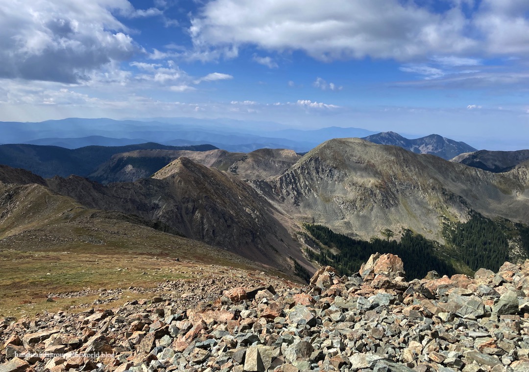
It wasn’t too much longer before the forest began to thin, trees smaller and fewer in number. As we zigzagged up the western slope of the mountain, we could now look down on Williams Lake, across at Lake Fork Peak… and up at the elevation gain that awaited us.


Over a dozen switchbacks lay ahead en route to the saddle between Wheeler Peak and Mount Walter. This climb was a steep, rocky, switchback sufferfest in which we gained 1100 vertical feet (335 m) in about 1 mile (1.6 km). The second to last switchback in particular was brutally steep. This was by far the most difficult part of the hike; it took us 45 minutes (and a lot of gasping for breath) to cover this distance.


But at long last, we crested the ridge.
From here, it was only about 0.2 miles (0.3 km) and 100 feet (30 m) to the summit… a walk in the park in comparison to what we’d just climbed. While most of the hike up to this point had been fairly calm, a cold wind was blowing along the ridge. I was regretting wearing shorts.


There were about 8-10 other people on the summit, but it was spacious enough that all of us could find our own spot to sit and enjoy the views. Everyone was also very good about taking turns with the summit sign and register and offering to take photos of one another. It’s always nice to have that kind of camaraderie.


We spent about 30 minutes on the summit taking photos and eating a snack and enjoying the view before retracing our steps. Descending the switchbacks was just about as difficult as ascending, though obviously in a different way. The rocky sections were slippery and our knees didn’t appreciate the steepness; I highly recommend hiking poles. They made our lives much easier.

This time, when we reached the Williams Lake turnoff we took it. It’s only about 0.2 miles (0.3 km) to the lake. As a shorter and easier hike, the lake was much more crowded than the summit trail. In comparison to other lakes we’ve visited, we also didn’t find this one to be that outstanding. We looked at it for about a minute and then turned around and continued back to the trailhead.

At the recommendation of the owners of the campground we were staying at, upon our return to the trailhead we stopped for lunch at The Bavarian. It’s located right along the trail, about 0.2 miles (0.3 km) prior to reaching the parking lot… perfect for some post-hike beers and German food.
(With this in mind… be sure to bring your wallet with you on the hike so you don’t have to run back to the car first.)
The Bavarian was delicious and I’m so glad it was recommended to us! It was definitely a splurge… we don’t eat out that much, and when we do we certainly don’t usually spend so much money on a meal. They had two German beers on tap, sold in 18 oz (530 ml) or 32 oz (950 ml) sizes, as well as a full German menu.
As an appetizer, we ordered a pretzel that was bigger than my face and could have been a full meal of its own. For entrees, I had a sausage bratwurst and my fiance ordered spätzle with sausage. He also indulged in the giant 32 oz beer while I ordered the slightly more reasonable 18 oz size.

And then, full of food and exhausted from our hike, we headed out of the ski area and back toward Taos.
The Important Stuff:
- Getting there: the Williams Lake Trailhead is located at the south end of Taos Ski Valley; follow signs through the ski area or use a maps app.
- Fees and passes: none.
- Hiking: with the short side trip to Williams Lake, the roundtrip distance is 8.9 miles (14.3 km) with 2960 feet (903 m) of elevation gain; strenuous.
- Where to stay: the closest (and most expensive) lodging would be at the ski area itself. For less expensive options, try hotels, rentals, or campgrounds in Taos (about 45 minutes away). For free options, there are a lot of dispersed camping sites in the surrounding Carson National Forest, including right along the road into the trailhead. Backpacking is also an option; near Williams Lake is the best location to pitch a tent.
- Other: elevation and weather are probably the main challenges associated with this hike. A lot of time is spent above tree line without any shelter, and it’s slow going due to the altitude; start early and keep an eye out for thunderstorms.
Leave a Reply