Last week, I wrote all about Bandelier National Monument, which protects the cliffs, canyons, and Ancestral Puebloan ruins south of Los Alamos, New Mexico. This landscape was created by the two massive eruptions of a nearby volcano more than 1 million years ago. After the final eruption the volcano collapsed, leaving behind a caldera 14 miles (22.5 km) wide. Today, that caldera is the centerpiece of Valles Caldera National Preserve.
Valles (pronounced VY-ase) Caldera is a relatively new addition to the NPS, created in 2015. Prior to this, the land was owned by a trust. Prior to that, it was owned by a series of farmers and ranchers, dating back to the original land grant in the 1820s. Some of the buildings and fences from these establishments still stand today.
Due to its new status and remote location, Valles Caldera is very undeveloped. One road – NM Highway 4 – cuts across the southern edge of the preserve. From here, an unpaved road turns north and heads into the caldera, past the visitor center and historic cabins, and then forks in the northern section of the monument. Driving parts of this road requires high clearance and possibly even 4WD, and most of it is closed in the off-season. Therefore, we were somewhat limited in our explorations of the caldera. Nonetheless, we enjoyed our time here.
We began at the entrance station, where we picked up the free permit that allowed us to continue driving to the historic cabins (which is as far as you’re allowed to go in the off-season). The cabins sit on the western edge of Valle Grande, the lowest part of the caldera. One of the cabins is now the visitor center, which we also stopped at briefly. At the recommendation of a ranger, we walked a short distance down an old road on foot. The path continues for many miles, but we had other hikes on the agenda so we turned around after about 10 minutes.


Back at the entrance station, we followed the Pond Trail out to a small pond in the center of Valle Grande. Although a short and easy hike (roundtrip 1.1 miles/1.9 km), I enjoyed the panoramic views from this trail. With the brown vegetation and lack of trees, there was a starkness to the landscape that I really loved. I’ve never quite understood why, but I find desolation to be so beautiful.


Back at the car, we made our way back toward the highway, stopping for a brief climb up Missing Cabin Trail. This trail isn’t even on the park map; I think I learned about it from the website when researching for this trip. It’s also not marked. In fact, the official directions say to drive about 0.5 miles (0.8 km) into the preserve and park at the locked gate on the west side of the road.
From here, step over the gate and walk up the road to the cabin. The roundtrip distance was only 0.4 miles (0.7 km); it’s not a difficult walk.


Our last stop in Valles Caldera was the Valle Grande Trail, which is accessed off the main highway adjacent to the southeast boundary of the monument. It’s not well-marked and we nearly missed the pullout.
If you cross back into Bandelier (traveling east), you’ve gone too far. T
he parking area is on the opposite side of the road from the trail, which created additional confusion. But we eventually found it, dashed across the highway, and located the trailhead (which actually does have a small sign).
The Valle Grande Trail zigzags through the forest and descends to the southern edge of Valle Grande. After having hiked around the other parts of the caldera, it was neat to look across at them from a different angle. The only downside to this trail was climbing nearly 400 feet (122 m) in 1 mile (1.6 km) to get back to the car.


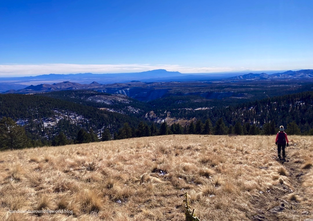
And lastly, as promised last week, an overview of our hike up Cerro Grande. At 10,200 feet (3110 m), this is the highest point in Bandelier and sits right on the border with Valles Caldera. I’m opting to include it in this post because the summit provides a stellar view of the caldera. And though the trail is entirely in Bandelier, the summit is partially in Valles Caldera.


Of everything we did on our New Mexico road trip, this hike was my favorite.
I know, I know. How predictable of me. Of course standing on top of a mountain with 360° views was my favorite activity. I’m nothing if not consistent.
In addition to the caldera views, from the summit we could see Albuquerque, Santa Fe, and Los Alamos, and in the distance we even glimpsed the Sangre de Cristo Mountains and Wheeler Peak – the New Mexico high point. It was neat to see all the places we’ve been, and it helped solidify my mental map of central New Mexico.


We took some time to enjoy the panoramic vistas and eat a snack, but eventually it was too cold to remain on the summit. The warmth of the sun wasn’t quite enough to overcome the cold wind that was whipping up the mountainside.

So back to the car we went, waving goodbye to both Valles Caldera and Bandelier. Both places – but especially Valles Caldera – are relatively remote and unknown.
I’m glad we had the chance to visit both, and if you’re ever planning a trip to Bandelier, I recommend popping over to Valles Caldera while you’re in the area.
The Important Stuff:
- Getting there: Valles Caldera is about 30 minutes west of Los Alamos on NM Highway 4. Note that to exit Los Alamos from this direction, you must cross through Los Alamos National Laboratories, which requires an ID check upon entry. We were very confused when our GPS sent us this way, but it is in fact the only way through. Just stay on the main road and don’t take any photos on this short segment of the route.
- Fees and passes: there is no charge to enter the monument, but a free permit is required to travel beyond the entrance station. Obtain this in-person at the entrance station.
- Where to stay: there is no lodging of any type in the preserve. For camping, check out the adjacent Bandelier National Monument or Santa Fe National Forest. For hotels, cabins, etc. Los Alamos is the closest town. This is where we stayed.
- Hiking: There are dozens of trails in Valles Caldera, but note that many are not well-marked and some require travel down the backcountry roads that require 4WD/clearance and a permit. For more information on access and availability, check in at the entrance station upon arrival.
- Other: because Valles Caldera is a national preserve, hunting (with appropriate permits and licenses) is allowed within its boundaries. If visiting during hunting season, wear bright colors (pink or orange are recommended) for safety.
Leave a Reply