Handstands Around the World

a former gymnast with a neverending case of wanderlust


Hagerman Fossil Beds National Monument & the waterfalls of southern Idaho

After departing the Sawtooth Mountains a day early due to inclement weather, we headed south, out of reach of the worst of the massive storm. The skies were still cloudy and it was a little sprinkly, but at least it wasn’t dumping buckets of rain (or snow) on us.

Since this was a last minute change to our trip, we went into it relatively blind. Aside from checking the weather and confirming that places were open, we hadn’t done much research, so we really didn’t know what to expect.

It turned out to be a day of surprises and disappointments.


Table of contents


Hagerman Fossil Beds National Monunment

Our first stop, about an hour south, was Hagerman Fossil Beds. Unfortunately, this monument was a bit of a disappointment. Having been to other NPS sites with fossils, I assumed we’d at least get to walk a short trail and see some of them.

We did get to see a few fossils, as there’s a small collection at the visitor center – though many are casts or replicas. This includes fossils of the Hagerman horse, the prehistoric single-toed horse for which the monument is named.

Hagerman horse fossils (L-R: brain, foal skull, adult skull)

The first Hagerman horse fossils were discovered by a rancher in the early 1900s; little did he know, he’d stumbled upon a fossil bed with over 100 skulls, 5 nearly complete horse skeletons, and dozens of other species. The fossils span 1.5 million years of history, including a period of global warming that is being studied for its relevance to today’s climate changes.

Various bird fossils
Left: bone-crushing dog fossils
Right: mastodon jaws and teeth
Left: sabertoothed cat fossils
Right: mastodon tusk segment
Left: peccary skull and jaw
Right: various feline fossils
Mastodon skull

However, the actual fossil beds are off limits to visitors. And while I understand that from a research and conservation perspective, I found myself wondering why this place was even open to the public at all. We spent 20 minutes at the visitor center, and that was basically it.

The only other stops at Hagerman are along the scenic drive, with viewpoints of the Snake River (which is pretty, but there are other sections that are much prettier) and Oregon Trail Ruts (which I suppose are neat if you’ve never seen them before).

Snake River Overlook
The Oregon Trail ruts are visible on the right side of this photo near the powerlines

In summary, this monument was not really what we expected and is probably only worth a stop if you happen to be passing by.


Thousand Springs State Park

Sharing a visitor center with Hagerman is Thousand Springs State Park, and this turned out to be the surprise of the day.

I’m not sure if there really are one thousand springs, but even so, the park is well-named. All throughout the area, springs bubble up out of the ground. The Snake River has cut a deep canyon through this portion of Idaho and many of the springs emerge from the canyon walls and tumble down into the river in cascading waterfalls.

The park itself is somewhat inconvenient to visit, as it’s comprised of six disconnected sections that are all a few miles away from each other. We ended up visiting four of the six, the first being the visitor center.

From there, we headed north to Malad Gorge, a deep canyon carved by the Malad River. Though the river is only 12.5 miles (20 km) long, the gorge is 250 feet (75 m) deep, making for an impressive journey.

A scenic drive runs through the Malad Gorge section of the park, stopping at multiple viewpoints providing various perspectives of the gorge. The first is right next to the interstate but, despite the vehicle noise, this was my favorite viewpoint.

Stop 2: Malad Gorge Overlook, with Devil’s Punchbowl (the waterfall) visible in the depths of the canyon. The green areas visible on the canyon walls are fed by springs that flow into the river.
Stop 3: Uses of Water Overlook, where the diversion channel built for power generation is still visible today.
Stop 4: Block Fault Overlook. Here, we could see the layers of rock that formed and eroded away to form the gorge. The water diversion structure is still visible too.

Next, we headed south to Ritter Island, home to the first of the handful of springs we would see on our tour. Though the footbridge to the island was closed for the rest of the day, we were able to walk a short path along the river’s edge to the base of the springs.

Ritter Island springs

We skipped over the Box Canyon section because we didn’t have time to hike to see the springs, so our final stop was Niagara and Crystal Springs. The entrance fee we paid at Malad Gorge got us into this section as well (the fee covers all Idaho state parks for the day). Just past the entrance is Niagara Springs, while Crystal Springs is a few minutes down the road.

Multiple springs emerged from the lower canyon walls (visible in the photos above) and tumbled into the lake at Crystal Springs
I forget what this one was called, but it’s between Niagara and Crystal Springs
Niagara Springs

I’m glad we stumbled upon this state park, because it was a neat place.


Shoshone Falls

Our final stop of the day was Shoshone Falls. Located just outside of Twin Falls, Idaho and operated as a city-owned park, this large waterfall is (theoretically) a highlight of the Snake River.

And honestly? It didn’t even feel worth the $5 admission fee. It was utterly disappointing.

Shoshone Falls has been dubbed the “Niagara Falls of the west,” and had it been flowing at capacity, it would have been. Instead, we got to see it at about 1/4 capacity, surrounded by a bunch of dry white rock.

Shoshone Falls

It’s bad enough that there’s a dam at the top of such a beautiful natural wonder. But then to charge people admission to come see the waterfall when the water is being held back by the dam and flowing over the waterfall at such low levels?

It felt like such a rip off.

Looking downriver from the falls

Also, I have no idea where my $5 went, because the aside from parking, some viewing platforms, and bathrooms that are in serious need of an upgrade, there wasn’t much here.

This was definitely the most unpleasant surprise of the day.

(If you’re curious, here is what Shoshone Falls is supposed to look like.)


Bechler Falls

Bechler Falls is located in Yellowstone National Park, albeit in the remote southwestern corner that few visitors ever venture into. I’d actually been there before but was too young to remember, so when I realized it was just a 45 minute detour from our planned route the next morning, I decided to make it a last-minute addition to the itinerary.

Reaching Bechler requires driving about 15 miles (24 km) on a gravel road. Thankfully, it was in good condition. Any car should be able to make it in summer conditions.

As we approached the Yellowstone boundary, the road forked. We went left first to visit the ranger station. As soon as we pulled in, my mom commented that it looked very different than she remembered. From talking to the ranger, we learned that a new ranger station and employee housing had been built within the last five years.

However, the old ranger station, housing, and barn built by the army back before the advent of the National Park Service still stands.

Old Bechler Ranger Station

After chatting with the ranger to learn more about the Bechler area (and obtaining the only Yellowstone passport stamp missing from my collection!), we headed back to the fork in the road and then followed the right branch to its end. Our destination was the two most accessible of the many waterfalls in this area: Cave and Bechler.

We stopped first at a pullout prior to Cave Falls at a waterfall that doesn’t seem to have a name.

Unnamed waterfall
Looking upstream from the unnamed waterfall, we caught our first glimpse of Cave Falls

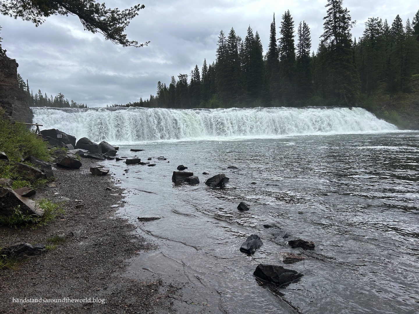
The road ends at Cave Falls, which is the widest waterfall in Yellowstone at 250 feet (76 m) across.

Cave Falls
Cave Falls (with me for scale)

To see Bechler Falls, though, we were going to have to hike.

It had been raining on and off throughout the morning, so we donned our raincoats, grabbed our backpacks and bear spray, and set off.

(My mom also put on her rain pants, which was a good decision. I did not, and ended the hike with soaking wet pants that were completely plastered to my legs.)

Being in a somewhat hidden corner of the park, the Bechler River Trail is not well-traveled. It’s narrow, with bushes right up to the edge, while lodgepole pines rise far above. It’s lush and green and lovely.

It was also utterly deserted.

While it’s always nice to find some solitude, grizzly country is not my preferred place to do so. Acutely aware of the fact that we were completely alone out here, my mom and I promptly started singing as loudly as possible.

There were either no bears in the area or our singing successfully kept them away. Either way, it was a bear-free hike.   

Bechler Falls

Mesa Falls Scenic Byway

Our final stop was the Mesa Falls Scenic Byway, a 30 mile (48 km) stretch of highway along the Henry’s Fork of the Snake River. The highlight is Mesa Falls: a series of two waterfalls that can see as much as 2.5 billion gallons (9.5 billion liters) of water per day at peak flow.

Coming from the south, we reached Lower Mesa Falls first. The viewing platform is quite a distance above the waterfall, but even so, we could see it down below and hear the roar of the water flowing over it.

Lower Mesa Falls

Just a short distance up the road is Upper Mesa Falls, by far the more popular of the two. Despite the less than ideal weather, the main parking lot was full when we arrived. Thankfully, there’s a spacious overflow lot that had plenty of space.

We ate a quick lunch at one of the picnic tables before grabbing our raincoats and heading down to the falls. A network of boardwalks meanders out to the edge of the canyon, along the river to the waterfall, and then back up to the parking areas. I’d estimate we walked maybe 1 mile (1.6 km).

Upper Mesa Falls
Taken just upstream from the falls. If only the water knew what was coming.

Upper Mesa Falls was one of my favorite waterfalls of this trip. Standing at the brink, it was impossible not to comprehend the sheer volume of water and the power with which it tumbles over the edge.


And this wraps up our impromptu waterfall tour of southern Idaho and our annual mother-daughter roadtrip. It wasn’t the last two days that we had planned but – Shoshone Falls notwithstanding – it was a good ending to our vacation.

54 responses to “Hagerman Fossil Beds National Monument & the waterfalls of southern Idaho”

  1. I was going to say this when I first saw this post (but then I forgot!): I knew you’d just been in Iceland and when I saw the photos of Malad Gorge, it somehow reminded me of Þingvellir … am I nuts?

    1. You know, I do see the resemblence!

  2. that’s amazing that you can still see the ruts in the ground from the Oregon Trail! One of my bucket list items is to do a road trip that follows the Oregon Trail and the Pony Express Trail. Such a beautiful collection of waterfalls throughout the southern part of the state.

    1. Yeah, it’s hard to imagine how many wagons must have traveled this route to leave ruts that deep. It also makes me wonder how the animals pulling the wagons navigated it, and how none of the wagons got high-centered. The ruts are really deep in some spots.

      1. I can’t even imagine what kind of slow and difficult journey that must have been.

  3. I like a waterfall – and how lucky were you to see such beautiful ones! It’s incredible to see the green areas in the gorge – almost unexpected. Oh yes, and I love the video of Niagara Springs – great to see water flowing so naturally. Maybe some of your sights were a miss, but I still think you saw really beautiful areas.

    1. Really, other than a couple bummers, it worked out well. I liked most of the waterfalls a lot!

  4. Wow! some wonderful photographs as usual. I love Niagara Spring. I must admit I’m very drawn to water of any type and these waterfalls all look wonderful.
    I took my daughter away on a Mummy/Daughter trip this year. You’ve nipped me to make it a yearly event 😊🙏

    1. Thanks! We really liked that one too. And fun! I hope you can make it an annual thing.

  5. I really appreciate all your reviews! Now that we have a camper van we are branching out. This area is on the bucket list now and this is a great resource!

    1. Oh how fun! My husband and I have talked about getting a camper van someday. I’m looking forward to seeing what you get up to in your new ride!

  6. I can see the appeal of Shoshone Falls when there’s lots of water tumbling over the boulders… but I agree, 5$ for the experience you had feels like a let-down in comparison. Malad Gorge looks neat though, as do all the springs you visited. I guess when you have to change your plans last-minute, there will inevitably be some pleasant surprises and a disappointment or two. At least you dodged the storm!

    1. As you said, it’s bound to happen. All things considered, things turned out pretty well for our last minute plans.

  7. Some really lovely scenery, especially Upper Mesa Falls and Bechler Falls, despite a couple of disappointing destinations. The loud singing made me chuckle, I’m glad you did not meet any grizzly bears.

    1. Thanks, Leighton!

  8. A great detailed write-up and love the photos…maybe one day I’ll get there…

    1. Thank you! I hope you do. Idaho is well worth a visit.

  9. Well, you saw some beautiful stuff, even if some of it was disappointing. That waterfall you saw compared to how it usually looks is quite different! Glad your time was grizzly-free… and moose-free!
    I’ve never seen Oregon Trail ruts before. I didn’t know they were a thing!

    1. No grizzlies, and a surprisingly small (for me) number of moose so far this summer. You will not hear any complaints from me about that. And yep, in some places the ruts were worn in so deep that they’re still visible all these years later. There are actually some places in your very favorite state where you can see them (I’m kidding about the favorite part, I’m talking about Nebraska 🤣 I’m not kidding about the ruts, though, you can see them at Scotts Bluff!).

      1. Oh dang – I missed them at Scotts Bluff. Well, since I’m never, ever, ever going there again, I guess they will have to remain missed.

        1. Well, if you’re ever in WY or ID you can see them there too!

          1. That’s a better plan.

  10. Ritter Island springs is STUNNING. Looks like something out of a movie. I also laughed at “inclement weather”, we use that in England when the trains are running late and they announce on the platform “this train is delayed due to inclement weather”. I’ve never heard it used anywhere else….until now! 🙂

    1. That was one of my favorites too! And oh, really? Inclement isn’t a word I use a lot but it’s definitely one I use when talking about less than ideal weather.

  11. Haha…I thought the modern paved highway in that photo was the Oregon Trail ruts for a moment. I was wondering why everyone made the expedition sound so dangerous, as navigation looked pretty simple to me!

    Oh, Mark…

    1. Hahaha well to be fair, the road was following the original trail! I think in some places it may have actually been built right over the top of it.

  12. You guys certainly put in some miles, Diana. There are 3 or 4 falls within a few miles of Shoshone that Peggy and I enjoyed cascading down into the Snake River that are free! A little side road takes you down into the canyon. Chuckled at the singing loudly in grizzly bear country. Peggy and I have done that! I was stalked by one in Alaska. No fun there.

    1. I wish we’d had more time to see those other waterfalls, because I think I would’ve like them more. Unfortunately, we just ran out of time.

      1. Yeah, darn work, always getting in the way of our play time. Grin. They were definitely worth seeing, although you might have had the same problem with water-flow.
        I always think of Evel Knievel when I get near Twin Falls and his attempted jump across the Snake River there. At least partially because I dated the daughter of the rocket scientist who built Evel’s rocket cycle when I was in high school.

  13. I’ve seen Idaho Falls, and knew they had several others, and it looks like you saw most of them. We just returned from northern BC, which reminds me of the thousand springs area. Are there not grizzlies in Colorado?? Overall, a great time with your mom. Maggie

    1. Somehow we didn’t actually see Idaho Falls… I’m not sure how we missed it. Hmmm… And nope, no grizzlies here, just black bears. There used to be grizzlies but they’ve been extinct here for about 100 years I believe.

  14. Your pictures are absolutely stunning and your post is very informative. The posts about Southern Idaho are inspiring me to travel with my family there. My son loves fossils.

    1. Thank you! It’s not the best fossil site ever but there are some to see in the visitor center. Worth a stop if you’re in the area, though.

  15. Glad you managed to avoid the worst of the rain, even if it meant having to change your plans. Hagerman Fossil Beds does sound rather underwhelming – a visitor centre and a few scenic viewpoints … that’s it!? But thank goodness the Thousand Springs State Park made up for things.

    1. Yeah, I was really underwhelmed. I’ve been to other fossil-based sites that had so much more to see. I’m not sure if this one was just new or underfunded or what, but it was far from the best fossil experience.

  16. A wonderful travel story with breathtaking scenery and a real sense of adventure throughout.

    1. Thank you!

  17. I think you and your mom had some wonderful experiences, even if not everything worked out according to the original plan. I have the feeling that you like to plan your trips to the nines. We often just head out to see what we can see and do. Of course, this comes with risks, such as not finding a campsite for the night, or missing out on cool places and things to do because we didn’t know they existed.

    1. I’m definitely an extensive planner. I never want to miss anything. But I’m trying to be better about not being quite so rigid, because like you said, sometimes things don’t work out as planned. It’s a work in progress…

      1. I think you also have more exacting standards than I, based on some of your criticism. 🙂

  18. We passed by few of these places long time ago, on our drive from Yellowstone to Portland, through Boise. I remember being really impressed by the Snake River, and we stopped at an old dam, we learned how the dam was built 100+ years ago and how was modernized, but I can’t remember the name of it.. what an impressive amount of work for those times!

    1. The stop at the dam sounds really cool! I’ve done that a couple times at other dams and it was really interesting to learn about how they’re built and how they work. The Snake River is a really underrated river, sounds like you had a good time driving through the area!

  19. I really enjoyed the honesty of this post, especially the contrast between the places that lived up to expectations and those that didn’t. I particularly liked your description of the deserted Bechler River Trail and the slight tension of hiking alone in grizzly country. Sometimes the unexpected detours create the best travel memories.

    1. Thank you! Some good memories for sure, and some places I don’t ever need to go back to.

  20. I’d thought about visiting Shoshone Falls, but based on your posts and others online, it seems like it wouldn’t be worth it, especially during the warmer months when water flow is lower. Good thing to know that I won’t be missing out! Thanks for sharing the rest of your time in Idaho with us, Diana; certainly an underrated state!

    1. Yeah, I think it’s only worth it during times of high flow. I hope you have a good time in Idaho!

  21. Despite the disappointments, Diana, you saw some “Stuff”. We have often wondered about some attractions, like what are we getting for our admission fee. It does not always make sense. Happy Wednesday. Allan

    1. We did, we certainly made the most of our time in the area. Thanks, Allan!

  22. I have read about that Thousand Springs SP, Ritter Island and Niagara Springs…. That is the Big Lost River that goes underground at Big Lost Sinks and joins the Snake River Aquafer and this is where it reappears. Pretty cool!

    1. Oh neat, okay, that’s why there’s so much of it coming up. I have a feeling you’d like it here with all the waterfalls! I know there were others we didn’t have time for.

  23. The waterfall videos were outstanding!

  24. Such an incredibly informative post, Diana.

    1. Thank you!

Leave a Reply