There are many Lost Lakes in Colorado. Apparently. I didn’t realize this until I just googled “Lost Lake” in an attempt to verify the mileage of this hike and a whole bunch of options came up. Turns out there are at least 7 or 8 of them.
Back in the day, people must not have been very good at keeping track of all the lakes.
Anyway.
On an unseasonably warm February day a couple years back, we headed out with two friends to snowshoe to the Lost Lake that’s just outside of Nederland, Colorado. This is one of the more highly recommended snowshoe hikes in the area due to its proximity to the Front Range and relative ease. The last section to the lake is steep, but other than that it’s a gradual and scenic walk.
More recently, I returned to Lost Lake with another friend to experience the hike in more summer-like conditions. Sort of. We had an exceptionally rainy May in Colorado — and the mountains actually got a decent amount of snow — so it wasn’t exactly summer in the highcountry yet. But the creek was flowing and the lake was thawed, so it was still a fairly different experience than my winter excursion.
In light of that, I’ve decided to update and re-publish this post to include information from both hikes.
Lost Lake is located about 1.6 miles (2.6 km) from the 4WD Hessie Trailhead parking area, or about 2.1 miles (3.4 km) from the lower 2WD parking area. We don’t have a 4WD vehicle, but even if we did we wouldn’t have been able to make it to the upper parking area in the winter because it’s closed. In the summer, this truly is a 4WD-only stretch of road; you’ll need enough clearance to drive through water and over large boulders, tires that can handle rocks and mud, and experience driving rough mountain roads.
This is a very popular hike; we arrived around 8:30am on a Saturday in February and were able to park fairly close, but by the time we made it back to the trailhead at 11:00am parking was extending quite a distance down the road.
In June, we arrived at 6:30am on a Friday and were only the third car… but it was early in the season, a weekday, and the weather forecast wasn’t great; on a nice day and/or a weekend, expect the lot to fill completely by 6:30am, if not earlier. Parking is strictly enforced. They will ticket people parked illegally and block the road when the lot fills. To alleviate some of the congestion, consider taking the free shuttle from Nederland that operates Friday-Sunday.
Since we parked at the lower lot on both occasions, we began our hike by walking up the road to the 4WD lot. In the winter, we were able to remain on the road the entire time. It was snowy, with ice and even a bit of slush in places, but easily navigable with microspikes.

In June, the road was only partially navigable due to water. A lot of water. In places it was easily over a foot (30 cm) deep. Fortunately, there is a trail through the trees alongside the road that allowed us to avoid the worst of it. Even in August, when I completed a different hike from Hessie Trailhead, the road was flooded in places. Basically, don’t ever expect it to be completely dry.

(Hint – the one on the right is the 4WD road)


(note that everything alongside the road here is private property, so exploring the ruins is not allowed)
The small 4WD parking area is located at the end of the road, which dead ends at North Fork Middle Boulder Creek. From here, cross the creek on a bridge and begin your hike. Most of the trail, as well as the lake, is located within the Indian Peaks Wilderness Area, so standard wilderness restrictions apply (dogs must be on leash, permits are required for backpacking, etc).


After crossing the creek, the trail winds through the trees and then up into an open area, from which you can see the slopes of Eldora Ski Area on the hillside above. The trail ascends moderately here, curving around and affording some decent views back down toward Nederland too.


From here, the trail re-enters the trees and weaves back and forth along South Fork Middle Boulder Creek before crossing it once more. Note that there is a junction just before this bridge; for Lost Lake, stay left and cross the bridge. There is a sign pointing you in the correct direction.
In February, it was about at this point that we needed our snowshoes. In June, while the trail had been alternately dry or muddy up to this point, this was where we first encountered snow. There were just a couple large patches and there was an established path through them, but clearly this stretch of trail doesn’t receive a lot of sun and is the last to dry out.


This section beyond the bridge begins to climb more steeply alongside the creek, past a waterfall that was frozen in February but absolutely raging in June, before curving away and zig-zagging up the final bit of elevation to reach Lost Lake.


The lake was frozen solid in February, as to be expected, but the texture of the ice surprised us. Usually, due to wind and other winter weather, lakes freeze in rippled or wavy or bumpy patterns. Lost Lake, however, was smooth enough that we took off our snowshoes and spent the next 15 minutes sliding around on the lake like little kids.

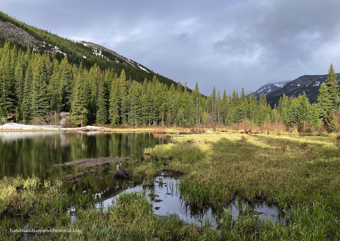
In June, the lake was fully thawed, though snow lingered on the surrounding hillsides. The white provided a nice contrast with the blue of the water and the various shades of green spread across the landscape.


A weekend of storms was already on its way into the Colorado mountains — hence our early morning start — so after a few minutes at the lake we began to re-trace our steps back to the car. The sun even came out for a few minutes as we descended, which turned out to be the last time we saw the sun for the next couple days.
I’m sure the crowds on this trail on a normal sunny summer weekend would be off-putting, but if you’re looking for a shorter hike in the area and you’re able to arrive early in the morning or on a weekday, this is a great option for a quick hike. It’s family and dog-friendly (dogs must be leashed), though you’ll need to be careful to keep pets and kids well away from the creek, as it was flowing rapidly enough to easily wash away anyone who might accidentally fall in. If you’re able to obtain a permit, this would be a decent choice for a beginner backpacking trip too. Lastly, if you’re a beginner winter hiker and/or snowshoer this is a pretty good option for both of those as well.
In summary: a not-too-challenging, versatile hike to a pretty Colorado mountain lake!
Up next: a short hike to the summit of Chief Mountain
The Important Stuff:
- Getting there: Hessie Trailhead is located at the end of Hessie Road in Eldora, Colorado, just a few minutes west of Nederland. The lower trailhead is accessible by all vehicles in summer (you’ll need snow tires in the winter). The upper trailhead requires high clearance 4WD. Parking fills absurdly early on summer weekends; consider taking the free shuttle from Nederland instead.
- Fees and passes: none for now, though a permit system is being discussed due to overcrowding.
- Hiking:
- From the upper (4WD) trailhead: 3.2 miles (5.2 km) rountrip with about 750 feet (230 m) of elevation gain
- From the lower (2WD) trailhead: 4.2 miles (6.8 km) roundtrip with 815 feet (250 m) of elevation gain; very rocky and a little steep in places, but a moderate hike overall
- Where to stay: this hike is an easy day trip from the Front Range, but to extend your stay in the area there are lodging and camping options in Nederland and on the surrounding Forest Service land, including a couple dispersed camping sites at the 4WD trailhead.
- Other: I just want to reiterate the water-related concerns one more time because there’s so much of it. Spring, summer, and fall, expect the 4WD road and trail to be extremely wet in places and, especially early in the season, expect the creek to be flowing heavily. A fall into the water would likely be fatal.
Leave a Reply