If a two-for-one is called a twofer, does that make a four-for-one a fourfer?
If so, this was a fourfer. Specifically, four 14er summits for the effort of one.
Or maybe slightly more than one.
Either way, the Decalibron trail is probably the most bang for your buck of all the Colorado 14ers.
Hiking Decalibron was not plan A for Labor Day weekend. It was also not plan B.
Plan A was to spend the weekend backpacking in Utah and summiting the highest point in the state, but the predicted 80% chance of heavy rain and thunderstorms for the entire weekend had us bailing on that plan for the second time in a row (though previously it was suffocating forest fire smoke, not rain, that forced us to cancel). Frustrating as it was, we weren’t willing to drive so far and hike 28 miles (45 km) just to get drenched and not be able to see anything from the summit.
Perhaps third time will be the charm?
Plan B was to head down to the San Juans for redemption on 14er Mount Sneffels, but the forecast there wasn’t looking so great either.
We were determined to do something, though, because we had taken Friday off work and we weren’t about to waste a vacation day.
Luckily, the weather closer to home was behaving much better. So we rolled out of bed at 4:00am and were on the road by 4:30 en route to Kite Lake Trailhead to hike Decalibron.
Before I delve into the details of this hike, let’s clarify:
- De = Mount Democrat
- Ca = Mount Cameron
- Li = Mount Lincoln
- Bron = Mount Bross
(Because apparently someone decided that Decalibron sounds cooler than Decalibross or Decalibro. That was probably the right call.)


We arrived at Kite Lake Trailhead, stopping at the fee station to pay our $8 (cash only). Much of this hike is on Forest Service land, but parts of Mounts Democrat, Lincoln, and Bross are privately owned. In fact, this hike is currently at the center of quite a bit of controversy in Colorado due to laws that don’t adequately protect landowners from liability if they choose to allow the public to recreate on their property.
Regardless of how you feel about the fact that someone is allowed to own a mountain, I completely understand where the landowners are coming from. They’re under no obligation to allow anyone to hike on their land, and they certainly shouldn’t be liable for someone who chooses to wander off the trail and falls into an old mine shaft, or slips and breaks their leg.
This trail was actually closed for most of the summer due to these concerns. It finally reopened in August, with the requirement that all hikers must sign a liability waiver prior to beginning their hike. It sounds like this is a temporary solution, so I immediately moved this hike to the top of my priority list in case it closes again in the near future.
Much to my surprise at 6:30am on the Friday before a holiday weekend, there were still a few parking spaces at the trailhead, so we snagged one, grabbed our gear, and we were off. The trail connecting all four summits is a loop, with a couple offshoots leading to the summits of Democrat and Lincoln. The total distance is about 7.8 miles (12.6 km), with an elevation gain of roughly 3500 feet (1065 m). The name Decalibron represents the order of summits if you travel in a clockwise direction, but most people suggest going counterclockwise.
We did the latter, which I guess means we should be calling this hike “Brolicade” instead. That sounds stupid, though, so I’m just going to stick with Decalibron.

The reason for the counterclockwise suggestion is Mount Bross. It’s just one enormous pile of loose rock that is apparently awful to descend. While I can’t specifically make a comparison since I haven’t hiked this trail both directions, it certainly didn’t look like something that was fun to walk down. To be fair, it wasn’t all that fun to walk up, either. We gained just over 2000 feet (610 m) in the first 1.4 miles (2.3 km) up to the Bross Bypass Trail at just over 14,000 feet (4265 m).


The summit of Bross is on private property. The new waiver system allows access to the other peaks, but Bross has a different owner who has not allowed any summit access for the last 15 years. It’s not like there’s a fence or cameras or anyone up there enforcing this closure, so plenty of people choose to ignore the no trespassing signs and climb to the true summit anyway. And to be fair, the sign marking the route could easily be pointing to the bypass trail or the summit trail, so I can see how someone might accidentally take the wrong path.
We, however, chose to respect the closure and not trespass on private land. The bypass trail travels above 14,000 feet (4267 m), and it’s as close as you can legally get to the summit, so that counts.


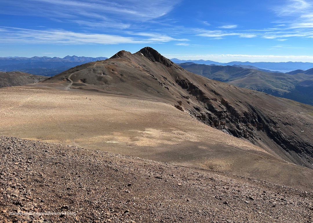
The bypass trail cuts across the western slope of Mount Bross (the lower of the two trails in the photo above) to a saddle between it and Mount Cameron at about 13,850 feet (4220 m). The trail continues along the east slope of Cameron, bypassing the summit for now en route to Mount Lincoln. It’s about 1.5 miles (2.4 km) from the Bross bypass to the summit of Lincoln.


Along the way, we came across a pickup truck that had been stuck on the side of Mount Cameron since earlier in the week. I don’t know why anyone would think they could drive their truck up to the summit of a 14er – and I’m 99% certain they ignored numerous No Trespassing signs to make it up this far – but apparently this person thought it was a good idea. I also have no idea how they’re ever going to get it down.

(Update: they did eventually manage to get it down.)
Anyway. Mount Lincoln was my favorite of these four peaks. The contours of the summit actually reminded me of climbing cinder cones in Craters of the Moon and, as the tallest one, it has the most unobstructed views. Using my Peakfinder app, I was able to pick out at least a dozen other 14ers, including a couple we’ve previously climbed.


From Lincoln, it’s just a quick 0.5 miles (0.8 km) over to Mount Cameron. For those who subscribe to the 300 foot (90 m) rule – which states that a summit must have at least 300 feet of prominence above its saddle to be considered its own mountain – Cameron is not technically a 14er. It only rises about 150 feet (45 m) above the Cameron-Lincoln saddle. While some people are diehard adherents to this rule, I – and from what I’ve observed, a majority of Colorado 14er hikers – choose to ignore it.


As we stood on the summit of Cameron, I began to understand the argument for completing the loop clockwise instead. We now had to descend 850 feet (260 m) to the saddle between Democrat and Cameron, and then regain 750 of those feet (230 m) to reach the Democrat summit. After already summiting 3 peaks, it wasn’t exactly an appealing endeavor. But we’d committed to the counterclockwise hike so down we went, taking what turned out to not actually be the trail off the summit of Cameron.
It was easy enough to navigate down to the actual trail, though, and when I turned to look back at the summit 5 minutes later, I saw both groups of hikers behind us making the same mistake. For the record, the actual trail heads off the north side of the summit.


Just under 1 mile (1.6 km) later, we reached the saddle. In front of us was yet another giant pile of rocks. Luckily, this rock pile was slightly more stable than Bross, though it was still slow going and required careful foot placement. This turned out to be a blessing in disguise, because I was so focused on watching where I was going that I was caught completely off guard when the terrain flattened out and I looked up to see the summit of Democrat just 150 feet (45 m) above us.


It was a relatively easy final climb on much more solid terrain. We crested the summit just prior to 11:00am and found ourselves standing on the Continental Divide, looking over into the East Fork Arkansas River Valley. The highway below is one we’ve driven numerous times, and it was strange to see what is actually a fairly high pass sitting so far below us.


After enjoying our fourth summit of the day, it was time to make our way down the pile of rocks to the saddle, and then back to the car. I was immensely grateful for my hiking poles on this portion of the trail, as it was a steep and at times slippery descent. My knees and ankles appreciated the extra support, and I definitely would have fallen multiple times without them. From the summit of Democrat, it was about 1.9 miles (3.1 km) with a drop of 2100 feet (640 m) back to Kite Lake Trailhead.
One thing that really stood out to me with these peaks is how barren they are. Most of Colorado’s mountains are similarly jumbled piles of rocks, but there’s usually plenty of plant life as well. On this hike, we saw very few plants until we dropped down from Democrat into the upper reaches of Kite Lake basin. This final section was scenic as we meandered through the meadow, with a cascading creek beside us and wildflowers clinging to the last few days of alpine summer.


We made it back to the trailhead around 1:00pm, feeling very accomplished at having summited four mountains.
Prior to this hike, my husband had only climbed two 14ers. When people asked how his weekend was, he enjoyed telling them that he tripled his 14er total.
While my accomplishment may not have sounded as impressive, the Decalibron summits brought my total to 13.
Only 45 more to go!
Up next: a day hike to Lost Lake during two different seasons
The Important Stuff:
- Getting there: Kite Lake Trailhead is located off County Route 8 (Buckskin Road) in Alma, Colorado. You probably could do it in a sedan if you’re really good at navigating rough roads, but I personally wouldn’t have taken my sedan up it. We had no issues in our Subaru, though.
- Fees and passes: there are two things you must do prior to this hike: (1) sign the liability waiver – which should be done online before you leave because service is spotty at the trailhead – and (2) pay the $8 cash daily usage fee.
- Hiking: distance for the full loop, including all 4 peaks but without trespassing onto the Bross summit, is 7.8 miles (12.6 km) with roughly 3500 feet (1065 m) of elevation gain; counterclockwise direction is recommended.
- Route: a complete and detailed route description can be found here. Before heading off on this hike, download the 14ers.com app and save the text and photos for offline use.
- Where to stay: with an early start, this can be done as a day hike from the Front Range, or Clear Creek, Park, or Summit Counties. Alternately, there are a few campsites at Kite Lake Trailhead for $20/night. Each has a picnic table and fire ring, there are pit toilets at the trailhead, and water can be filtered from Kite Lake. It actually looks like a pretty nice place to stay, and we spoke to a group who said it was chilly but they’d had a good night.
- Other: I’d estimate over half of the hikers we saw this day trespassed to the Bross summit. Please don’t do that. The more misuse that occurs, the more likely it is that access to these summits will be permanently restricted. It’s not that hard to just take the bypass trail, you’re only about 100 feet below the actual summit anyway, and it’s just a pile of rocks. There’s really nothing to be gained by trespassing other than bragging rights for being disrespectful of people’s property.
Leave a Reply