When I initially planned our Black Hills roadtrip back in January, it was for a four-day weekend. However, in the intervening months my husband’s work schedule changed, meaning we’d only actually have three days for this trip.
As soon as we learned this, I set out to rework our itinerary, trying my absolute hardest to condense everything from four days down to three. Despite my best efforts, it pretty quickly became clear that it just wasn’t going to be feasible.
Because we’d missed the initial booking window for Wind Cave and Jewel Cave tickets (post coming soon!) and had to settle for whatever was left, we ended up with afternoon tours on two consecutive days. This coupled with the location of the two caves meant we had to piece everything together, do some backtracking, and ultimately save a couple things for next time.
I’m not mad about it. We still had a great trip, and in the grand scheme of things we didn’t have to do that much backtracking. But rather than write this post in the jumbled order that we followed, I’m going to write it in an order that would make sense geographically if you were going to do this drive in one day – which is what we would have done if we didn’t have a mid-afternoon cave tour.

Our starting point is Sylvan Lake, the location of the trailhead for our Black Elk Peak hike. Custer State Park is relatively a rectangle, with the exception of the Sylvan Lake area, which is northwest of the rest of the park (map above).


I was very excited to have secured a reservation at Sylvan Lake campground. Set amongst endless ponderosas – my favorite of the pines – we found it to be a nice place to stay. Our site was towards the back with more solitude than many of the others; of course, the tradeoff was that it was further from the restrooms. Personally, that’s a tradeoff I’m willing to take.

(Note that the campground is by reservation only, a fact that was clearly lost on the guy who showed up without a reservation and was setting up his tent in our campsite when we arrived. Thankfully it didn’t become a whole thing; he simply apologized, packed up, and left.)
Exiting Sylvan Lake to the southeast, we’re now on the iconic Needles Highway. As you’ll see below, this is a road for small vehicles only; even some wide trucks or tall campervans may not be able to fit through the obstacles that lie ahead.
Specifically, the obstacles in question are the one-lane tunnels, the narrowest of which is only 8 feet (2.4 m) wide and the lowest of which is just over 9.5 feet (2.9 m) tall. (Note that the map above is wrong; Needles Eye Tunnel has less clearance than shown.)
If your vehicle fits, it’s fun to drive through! Just be sure no one is entering the tunnel from the other direction.

In addition to the tunnels, Needles Highway is just a neat drive. There are lots of pullouts to stop and admire the needle-like geology. Having mastered the art of the car picnic, we stopped at one of these for lunch with a view.


The road becomes slightly less curvy as it drops down and flattens out, eventually dead-ending at Highway 16A (the main east-west route through the park). If you need food, gas, or anything else, the town of Custer is just a few minutes away. We, of course, stopped for some beer.
We also stopped at Gordon Stockade Historic Site and Stockade Lake, simply because they were right there next to the highway and we were curious. The stockade was partially original and partially rebuilt, and the lake was calm and clear.


From here, the popular thing to do is head south on Route 87 and then left onto the Wildlife Loop, which travels through the plains of the southern half of Custer State Park, home to the park’s bison herd as well as a small herd of burros. Due to a lack of time, this was one of the things we had to skip. However, I drove this road on my previous trip; here are a couple photos from back then.


The Wildlife Loop returns to Highway 16A at the Custer State Park Visitor Center. From here, the driving loop continues east on 16A and then north onto Iron Mountain Road, which is similarly curvy and tunnel-y to the Needles Highway. We also had to skip this for purposes of time.
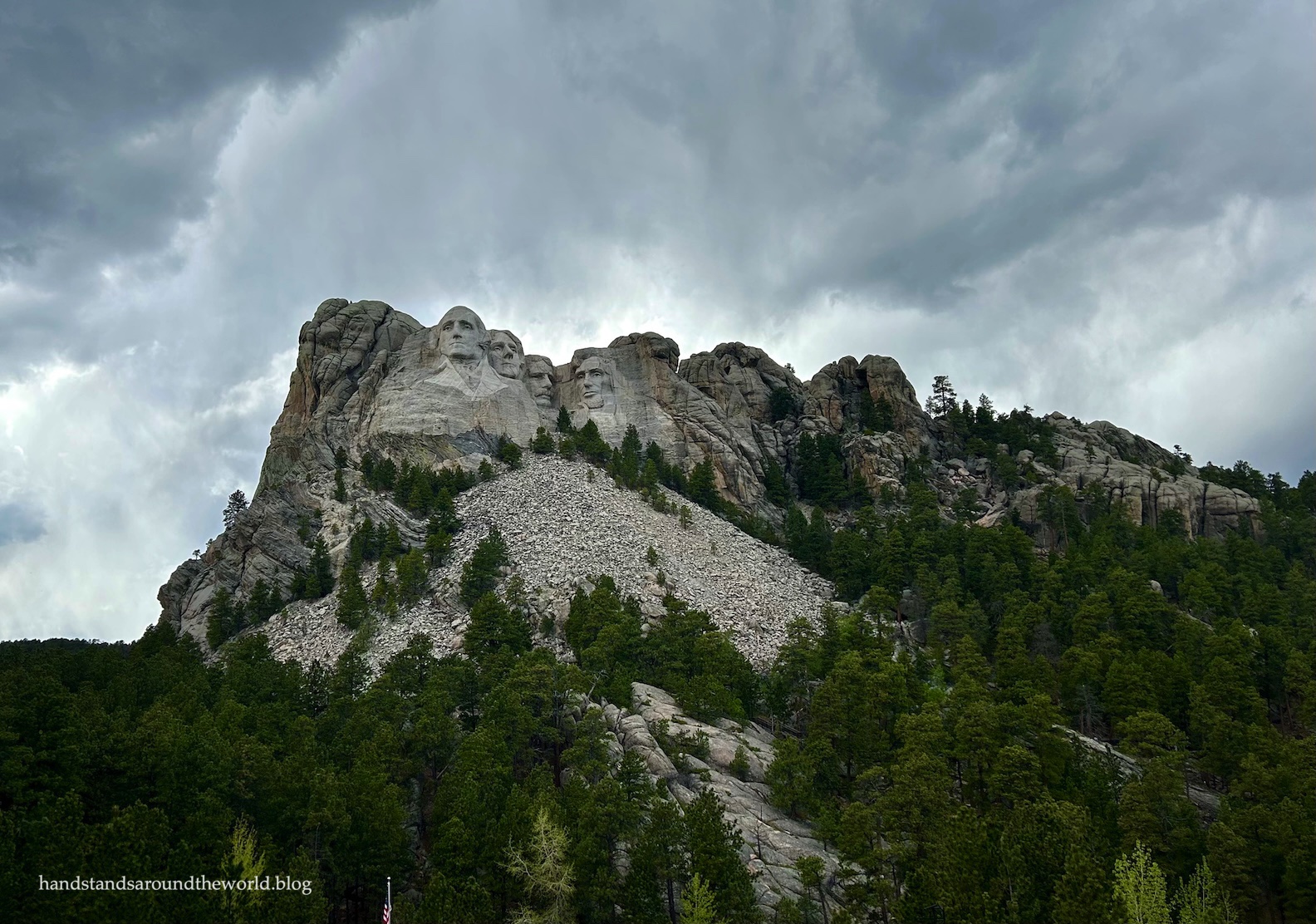
Notably, the northern terminus of Iron Mountain Road is Mount Rushmore National Memorial. We did visit Mount Rushmore, though we entered from the west because it was the faster route from our campground.

(photo taken by Chelsea on our previous trip)
I admit, I wasn’t all that excited for Mount Rushmore. I’d been there before, and for me it’s not really the kind of place you need to go twice. But my husband hadn’t been, so we made the stop.
I was worried it was going to be a total zoo, and it was definitely busy. However, we didn’t get stuck in traffic and we easily found a place to park. From the parking area, it’s a short walk to the main plaza, home to the gift shop, a restaurant, and an ice cream shop. Aside from needing to get my passport stamps and a magnet, we had no interest in any of this so quickly moved on.
Beyond the buildings is the Plaza of Flags, a walkway framing Mount Rushmore with flags of all 50 states + DC along the edges.

At the end of the plaza is the Grand View Terrace, which is where I expected to find the best view of Mount Rushmore. It wasn’t. A giant amphitheater sits below the platform which really detracts from the view.
Down below is the visitor center, which was chock full of information. It was approaching dinner time, meaning we definitely didn’t have the motivation to read everything. My husband was most interested in learning what Mount Rushmore looked like before and how it was carved, so we focused our attention on those exhibits.
Truthfully, though I’d gone into this with a relative lack of enthusiasm, I did find the construction of Mount Rushmore to be fascinating. It was definitely something I hadn’t cared about when I visited as a kid, but as an adult I could appreciate the challenges, skill, ingenuity, and flexibility (plans changed multiple times due to cracks and other problematic rock features) that went into carving four giant faces on a mountainside.

From my observations, most people visiting Mount Rushmore don’t go past the viewing platform. Some head downstairs to the visitor center. Almost none bother to walk the trail. This was where we found the most solitude.
The 0.6 mile (1 km) Presidential Trail departs from the southwest corner of Grand View Terrace, weaves through the trees, and emerges at the base of Mount Rushmore. As it travels along the front of the mountain, there are informational signs about each of the four presidents as well as a variety of unique viewpoints.

Mount Rushmore was envisioned as a memorial to the ideals of democracy and a symbol of the United States and the principles upon which our nation was founded. Principles that, as we approach our 250th birthday, we are very much struggling to maintain. But I digress.


Right: Abraham Lincoln was chosen to signify equality.


Right: Theodore Roosevelt was chosen to represent the role of the United States in the 20th century world.
The trail ends at the Sculptor’s Studio, which is where Gutzon Borglum, the man responsible for designing Mount Rushmore, did his work. That being said, about 400 people (and lots of tools, scaffolding, harnesses, and dynamite) were involved in the actual carving process, which took 14 years. Today in the studio, you can see the 1/12th scale model Borglum made.


The final stop as we depart Mount Rushmore to the west on Route 244 is at the profile view, from which George Washington is visible from the side.

From Route 244, we can turn left onto Route 87 and pass through one last tunnel on our way back to Sylvan Lake. Our scenic Black Hills loop is now complete!

Up next: back underground we go for a tour of Jewel Cave
The Important Stuff:
- Getting there: Custer State Park is centrally located in the Black Hills region, with Mount Rushmore just a few miles to the northeast. Both are easily accessible by highway, though large vehicles will be unable to pass through the tunnels on Needles Highway and Iron Mountain Road. However, there are alternate routes into both locations that are suitable for any vehicle.
- Fees and passes:
- Custer State Park: entry is $25/car for non-residents for a one week pass and can be paid with cash or card at all entrance stations. Be sure to display your receipt on your dashboard.
- Mount Rushmore: admission is free but parking costs $10, is not covered by an America the Beautiful Pass, and must be paid at a kiosk or the gift shop before you return to your car, so be sure to take your ticket with you.
- Where to stay: there are numerous campgrounds at Custer State Park and in the surrounding Black Hills National Forest. Many require advance reservations. Hotels, cabins, and other accommodations are also available at Sylvan Lake and in the towns of Custer and Hill City. There is no overnight lodging within Mount Rushmore National Memorial.
- Other: as mentioned above, be sure to check the dimensions of your vehicle before taking it on Needles Highway or Iron Mountain Road; vehicles wider than 8 feet (2.4 m) or taller than 9.5 feet (2.9 m) will not fit.
Leave a Reply