When I decided to commit to my highpointing goal, I had no intention of repeating any of these destinations. Of course, this assertion was made under the naïve assumption that I would never encounter any obstacles during my highpointing attempts.
It didn’t take long for Mother Nature to laugh in the face of my naivete.

But despite the utter lack of views from the Mount Washington summit, that is not a hike I’m keen on repeating. It was endlessly and exhaustingly rocky. It was cold and wet. It was a beast of a hike. Once was enough.
Fast forward a few years to my initial summit of South Dakota’s highest point, Black Elk Peak, during which I was met with a nearly identical view.

At the time, I didn’t necessarily have any desire to repeat this one either. After all, I still had nearly forty high points to go, so why expend the time and effort to redo this one?
But when my husband and I found ourselves planning a visit to the Black Hills – a place he’d never been – I knew this hike had to be on our itinerary. Black Elk Peak isn’t just the South Dakota high point; it’s also a neat hike, and I knew my husband would enjoy it.
(And though he does not share my highpointing goal, he doesn’t mind tagging along on my highpoint adventures. In fact, this would be his 17th state high point, leaving North Dakota as the only one I’ve done that he hasn’t. When I asked if it would bother him to someday end up one high point away from completing them all, his answer was a confident no. My brain does not comprehend this level of nonchalance when it comes to checking things off lists. But I digress.)
The trailhead for Black Elk Peak departs from Sylvan Lake, a small, clear, calm lake that sits against a backdrop of jumbled rock outcroppings that are so symbolic of the Black Hills. There’s actually quite a network of trails back in here, making for multiple possible route options.

We opted to ascend Trail #9, which gains about 1200 feet (365 m) over 3.3 miles (5.3 km) en route to the summit. The Black Hills are made from granite, and this particular granite is very rich in mica. In fact, the trail was littered with so much mica that it was literally sparkling in the sunlight. Unfortunately, I wasn’t able to capture a good photo of it.


There are a few junctions to navigate along this route, as it intersects with some of the other trails. All are clearly signed; we had no issues with navigation.
We did, however, have an issue with a bird that flew so close to me it actually brushed my leg with its wing. Not my favorite moment of the day.
All in all, we found this route to be fairly gradual, with just a couple steeper sections. Of course, we also have the advantage of living at elevation, so we weren’t bothered by the lack of oxygen. If you’re visiting from a lower area, you’re high enough here that you may notice a difference. The trail begins around 6000 feet (1830 m) and ends at just over 7200 feet (2130 m).

The final ascent to the summit is the steepest part. It was a fun section of trail, though!


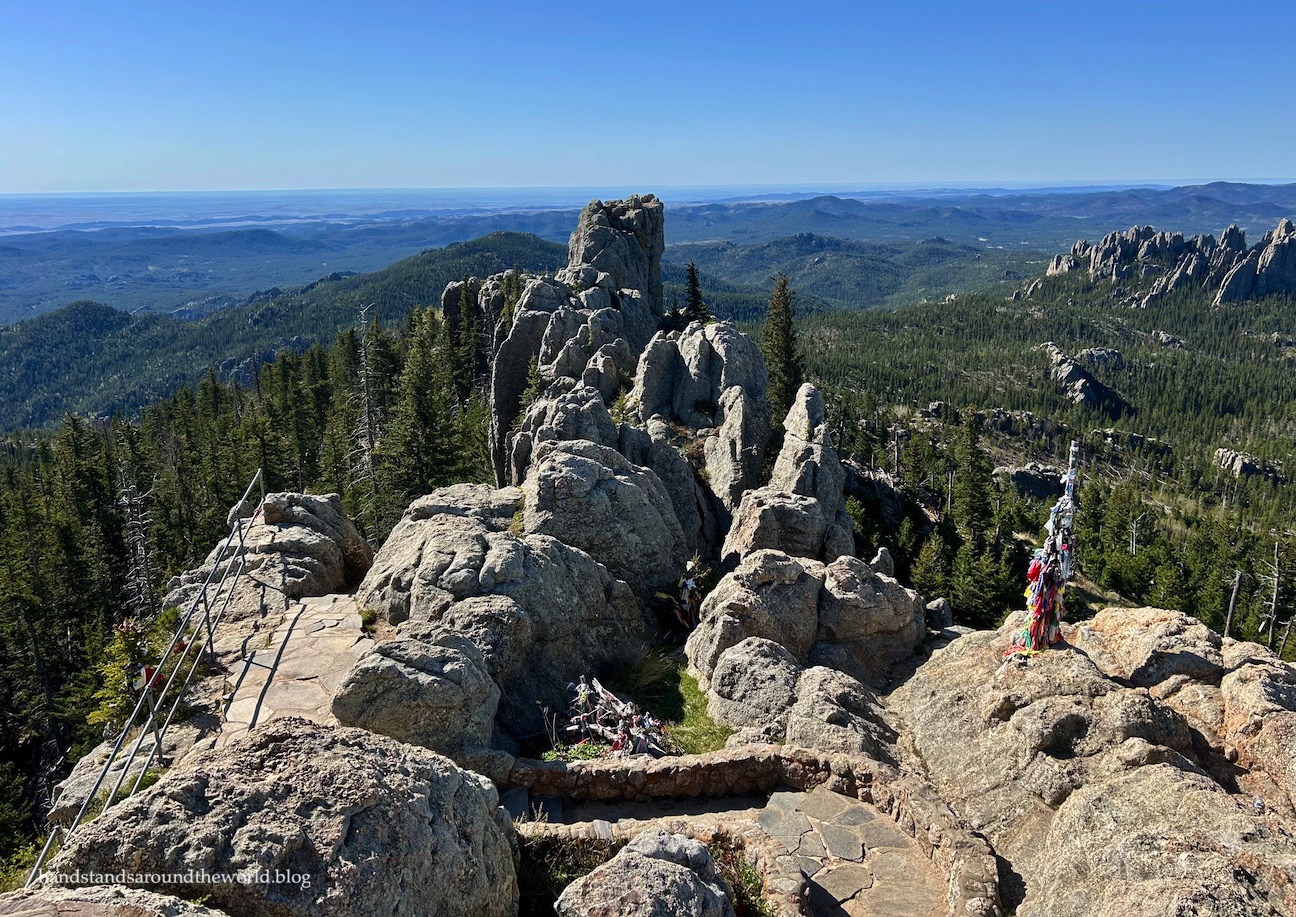
As we climbed the last stair, we found ourselves on the summit of Black Elk Peak. The high point is marked by the Harney Peak Fire Lookout.
(Harney Peak, by the way, is the former name of this summit. Given that William S. Harney, for whom it was named, was responsible for the massacre of the Lakota people, it seems appropriate to restore it to its original Lakota name. However, the name of the fire tower has not been officially changed.)


The summit is quite expansive, and views extend into the surrounding states of Montana, Wyoming, and Nebraska. There was just enough haze on the horizon that we weren’t able to make out any distinguishing features in the distance (the Badlands, for example), but the views were still extensive from this high point.
And in fact, Black Elk Peak is not just the highest point in South Dakota; it’s also the highest point between the Rocky Mountains and the Pyrenees Mountains!


We wandered all around the summit, ultimately settling in for a snack on the northernmost outcrop. The weather could not have been more opposite from last time; sunshine, just a light breeze, and scarcely a cloud in the sky. It was a beautiful day! Apology accepted, weather gods.

Of course, what goes up must come down, and we had afternoon plans, which meant it was time to get going. We opted to descend via Trail #4, which is less direct but allows for a couple side trips. About 0.5 miles (0.8 km) below the summit, we branched off onto Trail #3, which we then followed for about 1 mile (1.6 km) to Trail #4. From here, we remained on Trail #4 all the way back to Sylvan Lake, except for the short side trip to Cathedral Spires.


There’s an option for a side trip to Little Devils Tower too, but by the time we reached it we decided we didn’t feel like going. To be honest, after seeing the real Devils Tower two months earlier, we weren’t all that enthusiastic about something called “Little Devils Tower.”
Instead, we continued on Trail #4 all the way back to Sylvan Lake. Note that the route first reaches an alternate parking area for Trail #4 and Little Devils Tower. We got excited when we saw cars, only to have our hopes dashed when we realized it wasn’t our parking lot. From here, it’s still about 0.4 miles (0.6 km) back to Sylvan Lake.
Thankfully, it was a fairly easy walk back to our car. The parking lot was now overflowing; we were glad for our early morning start. And besides, our day was far from over… a busy afternoon lay ahead of us.
But I’ll save that for the next post.
For now, it was time to rest our legs, bask in the sunshine, and enjoy my South Dakota high point redemption!
Up next: an iconic journey through the Black Hills
The Important Stuff:
- Getting there: the main trailhead for Black Elk Peak departs from Sylvan Lake in Custer State Park, South Dakota. The road is paved and accessible by any car. However, parking overflows on weekends (Sylvan Lake is also popular for rock climbing, fishing, and boating), so plan to arrive early to secure a space.
- Fees and passes: though Black Elk Peak itself is in the Black Elk National Forest, the trailhead is in Custer State Park. Entry to Custer State Park is $25/car for non-residents for a one week pass and can be paid with cash or card at all entrance stations. Be sure to display your receipt on your dashboard.
- Hiking: depending which trail(s) you take (Trail #9, Trail #4, the Trail #9-4 loop, and the optional addition of Cathedral Spires), this hike is about 7-8 miles (11-13 km) round trip with approximately 1500 feet (460 m) of elevation gain.
- Where to stay: the Black Hills region is a popular tourist destination so camping, cabins, and hotels are plentiful in and around Black Elk Peak. We stayed at Sylvan Lake Campground, which conveniently meant we only had about a 3 minute drive to the trailhead.
- Other: though the stats for this hike are fairly moderate, the elevation of the Black Hills is higher than many people realize. The trailhead sits at around 6000 feet (1830 m) and the summit of Black Elk Peak is at 7242 feet (2207 m). Coming from Colorado, we were completely fine, but we passed some people from lower elevation who were struggling to catch their breath.


Leave a Reply