Last week, I wrote all about our weekend of peaches, hiking, and wine in Palisade, Colorado. The town is a decent distance west on I-70. We don’t head out this way too often, so we decided this was a good opportunity to make a stop along the way at a place that has been on my list for some time: Rifle Falls State Park.
This is a small state park – a campground and a couple trails around the waterfall and that’s about it. And while it’s a neat waterfall, it’s not, in my opinion, worth driving all the way out here just to see it. But since we’d be passing by anyway, this was the perfect opportunity for a visit.
Rifle Falls State Park is actually located a few miles north of I-70 on Colorado Highway 325. Traveling westbound, there was a lack of signage for this park. It’s much more clearly marked on the eastbound side of the interstate. However, my maps app got us here without issue, leading us along a winding two-lane road through what is apparently the home of dozens of wild turkeys.
Entry to the park was free with our Keep Colorado Wild pass. Without the pass, entry is $10/car. To reach the trailhead, proceed through the campground – which looks to be small and peaceful – and past the picnic area to the day use parking. From here, it’s just a short walk out to the waterfall on a paved trail.

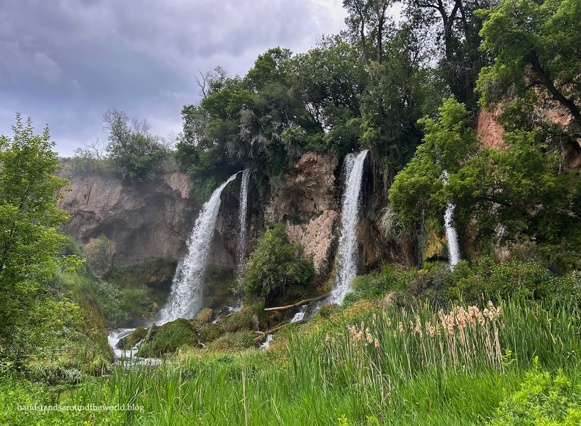
Uniquely, Rifle Falls was not created by erosion. Instead, the waterfall was built up from the ground by the calcium carbonate that precipitates out of East Rifle Creek. Thousands of years of accumulation has resulted in the 70 foot (21 m) waterfall we see today.
A stairway on the left leads up into an alcove behind one branch of the waterfall.


While many people simply walk out to the falls, the 1 mile (1.6 km) Coyote Trail loops around, past a series of limestone caves and up to the brink of the waterfall. This trail surprised me. I knew from previous research what the waterfall looked like, but I didn’t know anything about the caves. They were much neater than we expected!


Our route back to the interstate took us past the entrance to Rifle Gap State Park, so we decided to pop in for a quick visit. The reservoir here was formed by the damming of Rifle Creek to provide a steady source of water for the surrounding farmland. The dam was placed in the Rifle Gap – a narrow passageway in the landscape – giving the reservoir and state park its name.

If you’re looking to camp, fish, or partake in watersports, I can absolutely see the draw of Rifle Gap. It was calm and quiet, far from the crowds that overrun the bodies of water closer to the Front Range. For us, it was merely a fifteen minute stop to admire the lake, watch a few herons, and pop into the visitor center to get my Colorado State Parks Passport stamp.
In summary: not parks worth driving long distances to see, but if you’re passing through the area, definitely worth a stop.
Up next: summiting two more Colorado 14ers
The Important Stuff:
- Getting there: Rifle Falls and Rifle Gap State Parks are about 10 minutes apart on CO Highway 325 north of the town of Rifle.
- Fees and passes: entry is $10/car unless you have a Keep Colorado Wild pass.
- Hiking: there are about 3 miles (4.8 km) of trails at Rifle Falls, including the 1 mile (1.6 km) Coyote Trail loop. Rifle Gap has a few short trails along the northern edge of the lake. We didn’t hike any of these so I can’t offer any insights.
- Where to stay: there are campgrounds at both parks; the one at Rifle Falls is small but there are multiple larger campgrounds at Rifle Gap. All campsites are available by reservation only. Various types of lodging are also available nearby in Rifle.
- Other: if you plan to climb the stairs and walk behind the waterfall, prepare to get wet!
Leave a Reply to JyothiCancel reply