When we moved to Colorado, I made a rule that I was never waking up earlier than 4:00am to go hiking.
Unfortunately, these two 14ers are so popular that if I was ever going to climb them, I might be forced to break that rule. It was one of those moments where I was forced to reconsider my level of commitment to this whole climbing-all-the-14ers thing.
Stubbornly, I decided my answer was still yes.
And then the weather put the kibosh on our plans, rendering all my deliberations moot, at least for the time being.
My friend and I rescheduled for three weeks later… and then heavy forest fire smoke blew in from Canada, forcing us to cancel yet again.
A week later, third time was finally the charm.
My alarm went off at 3:00am and I groggily rolled out of bed, dressed, washed up, and was out the door by about 3:15am for the drive to the Grays and Torreys Trailhead.
The road to the trailhead is dirt, and a quick internet or social media search will reveal a wide range of accounts of its condition. On one end, you have people who somehow managed to drive their sedan to the trailhead. On the other, you have people saying the road is the worst they’ve ever seen it and absolutely impassable in a Subaru.
And while road conditions do vary throughout the year and often deteriorate as the summer goes on, I’m here to tell you that most of these reviews are overhyped. As of July 2024, you probably could not do it in a lower clearance vehicle. But it’s completely Subaruable. It’s slow going, due to potholes and rocks, but it’s not that bad.
There is one section near the top with a giant dip in the road, but it’s easy enough to go around. The guy in front of us tried multiple times to go right through it and kept getting stuck. He only made it around after I pointed out to him that he could easily bypass it if he just stayed left – proving that anyone’s opinion about road conditions probably says more about their driving skills than the road itself.

Anyway. We arrived to find, surprisingly, plenty of parking. Previous hikers had reported the lot filling early, which is why we arrived when we did. The only overflow parking is many miles down the road, making for an extremely long hike, so we didn’t want to risk not getting a spot. On this particular day, though, it turns out we could have slept in a bit.
(On weekends, by the way, the parking lot usually fills by 8:00pm the night before, as people will dispersed camp or sleep in their car at the trailhead.)
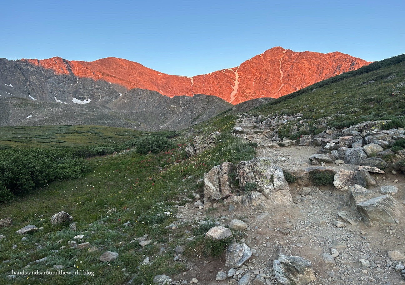
There were no thunderstorms in the forecast and it was still dark out, so we took our time getting ready to go, and when we finally set foot on the trail it was light enough that we didn’t need our headlamps.

The trail begins at around 11,200 feet (3415 m), crossing a creek and entering a meadow of willows. For a 14er, it’s a fairly gradual start, gaining about 700 feet (215 m) in the first mile (1.6 km) and only 400 feet (120 m) in the second.


Of course, the downside to a gradual first half is a steep second half, and that was definitely the case here. The final 1.8 miles (2.9 km) gains about 2000 feet (610 m). The latter half of the hike is also much rockier as it zigzags through some extensive talus. However, the trail is well-constructed and easy to navigate.


At around 13,300 feet (4055 m), you’ll have a choice to make: stay left to summit Grays Peak first or head right onto the connector trail and summit Torreys first. We opted to summit Grays first, for no other reason than it’s the way most people go. I’m not sure there’s much of a difference, though heading up Torreys first might be slightly shorter and steeper.
I did, at one point, have to quickly dash off the trail to make way for a group of mountain goats who decided to head in my direction. They weren’t being aggressive, just going about their day, but there was a baby in the group so I wasn’t going to take any chances. I simply went down and around and they stayed up on the trail, and we all went on our merry way.

And then it was just a slow and steady grind through the switchbacks to the Grays Peak summit.


In contrast to the relatively mild weather during the climb, the summit was cold and windy so we didn’t stay long.


From the Grays Peak summit, the trail descends to the north toward the Grays/Torreys saddle, dropping about 500 feet (150 m) and then regaining that elevation as it ascends the south ridge of Torreys. I actually got a bit of a second wind here, and the climb didn’t take as long as I was expecting.


Despite being only 0.7 miles (1.1 km) apart, the summit of Torreys wasn’t windy at all, so we lingered here a bit longer, enjoying the view and picking out familiar landmarks and other 14ers.


Pudgey, of course, posed for her summit photos on both peaks too.


The hike down was nothing special. We returned to the saddle and split off at the sign onto the Grays/Torreys connector trail which angled down through the talus and back to the main trail. From there, it was just a steady descent back to the car. Hiking poles were very helpful, especially in the rockier sections and through the oversized stairs.

We were back to the car by around 11:00am and heading back down the road shortly after. Again, the road wasn’t that bad, just slow. However, S was the one driving and commented that the road had looked better in the dark, when all the rocks and bumps were much less visible.
To be completely honest, these weren’t my favorite 14ers. There was nothing wrong with them, but there was nothing to really make them stand out, either. Other 14ers have prettier trails and more expansive views.
Nonetheless, I’m now two 14ers closer to my goal!
Up next: hiking to Booth Lake amidst thousands of wildflowers
The Important Stuff:
- Getting there: the main Grays and Torreys Trailhead is located off I-70 exit 221, at the end of Forest Service Rd 189. It’s about 3 miles (4.8 km) from the beginning of the dirt road to the trailhead, and high clearance (but not 4WD) is necessary. If you have a low clearance car, you can park at the large parking area and walk up the road, but it will add about 6 miles (9.6 km) roundtrip to your hike.
- Fees and passes: none.
- Hiking: roundtrip distance for both summits, starting at the upper parking area, is 8.4 miles (13.5 km) with 3660 feet (1115 m) of elevation gain.
- Route: a complete and detailed route description can be found here. Before heading off on this hike, download the 14ers.com app and save the text and photos for offline use.
- Where to stay: with an early start, this can be done as a day hike from the Front Range, or from other towns in the Clear Creek or Summit Counties. Alternately, there are a few dispersed campsites (and a bathroom but no potable water) at the trailhead or you can just sleep in your car.
- Other: parking is not allowed along the road, except in clearly-marked areas. Parking along the road not only prevents emergency vehicles from reaching the trailhead, but you may also get ticketed or towed. Clear Creek County does regularly patrol this road.
Leave a Reply