Two years ago, my friend and I made plans to hike to Tuhare Lakes with our husbands.
Two years ago was also an absolutely awful summer for wildfires in Colorado; forest closures, evacuation zones, and suffocating smoke thwarted many plans… including this one.
The original plan was to reschedule for summer 2021 instead, but we just never got around to it. Fast forward to August 2022, and we were finally able to put this one on the calendar. It had been a long time coming, and we were excited.
The hike begins at Halfmoon Campground at the end of Tigiwon Road near Minturn, Colorado. Tigiwon Road – marked by a misspelled sign pointing you to “Tigwon” Road – is dirt but pretty well-maintained. All the potholes are easily dodgeable (which spellcheck tells me is not a word, but I’m going to use it anyway). We had no trouble driving it in our Subaru and saw plenty of sedans at the trailhead as well.

What I failed to realize until we arrived, however, is that Halfmoon Campground is also the starting point for the Mount of the Holy Cross hike. This is one of Colorado’s 14ers, meaning the trailhead is pretty much always crowded, especially on weekends. Despite our early arrival, we found ourselves parking 0.2 miles (0.3 km) down the road.
Once you reach the campground, be sure you take the correct path. For Tuhare Lakes, follow signs to Fall Creek Trail and Lake Constantine. The hike to Lake Constantine is nothing spectacular. We were in the trees the entire way as the trail wove up and down through the forest. In my opinion, Lake Constantine wasn’t that great either. I personally wouldn’t have driven this far and hiked all this way (3.5 miles/5.6 km) just to see Lake Constantine.

Fortunately, the best was yet to come.
But first, we had to get through the mud. And the water crossings. And the scrambling.
The trail continues through marshy terrain along the shore, paralleling Lake Constantine for its entire length. It’s a long, skinny lake. Once reaching the far end, the trail follows the creek for a short distance before curving up and to the right. Apparently the trail forks and the other branch continues left toward Fall Creek Pass, but I never saw the fork.
There are no signs beyond this point, so I recommend having a GPS app or some other type of navigation to be sure you’re headed toward the lakes and not the pass.


After turning right, the trail begins to climb. Steeply. When we weren’t navigating mud puddles, we were scrambling over giant boulders.


As we crested one set of boulders, we suddenly found ourselves staring at a lovely waterfall. The trail continues alongside it, eventually ascending the headwall and dropping down to Lower Tuhare Lake.


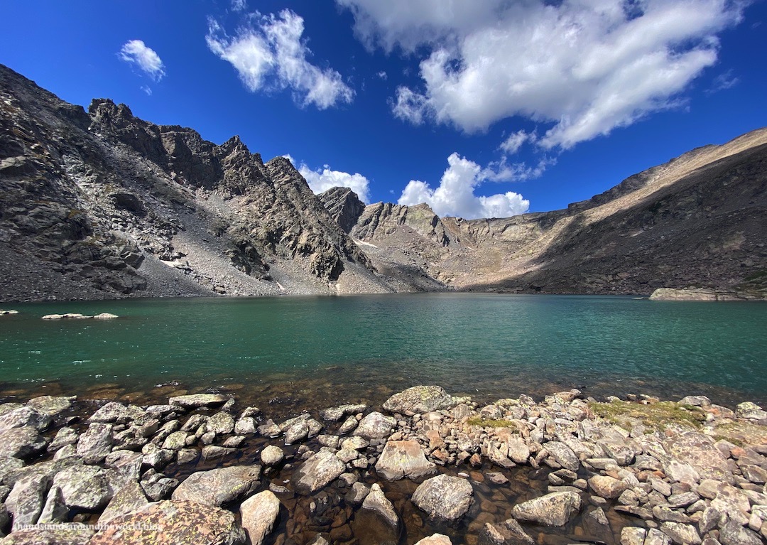
Upper Tuhare Lake sits in a cirque about 300 feet (90 m) above the lower lake. We followed the trail along the shore of Lower Tuhare and up toward a second waterfall, this one between the lakes. At times, the waterfall essentially was the trail. It was a very rocky climb; I’d classify the hike from Lake Constantine to Tuhare Lakes as a class 2.

But eventually, we reached the top of the waterfall and Upper Tuhare Lake… crystal clear and bright turquoise, sitting at an altitude of 12,400 feet (3780 m) and framed by the jagged Holy Cross Ridge.


This was my favorite lake of the day by far, and I personally could have hung out here all afternoon.
Sadly, I got outvoted. Everyone else liked Lower Tuhare best and, after about 15 minutes, wanted to head back down and spend more time at the lower lake. Reluctantly I followed, though not before climbing around on the rocky shore and taking far too many photos.


Now that we were facing the other direction, we were looking down on the lower lake from above, as well as out into the distance at the Mosquito Range. Notably, we could see Quandary Peak, the first 14er we ever summited. It feels like so long ago, and yet it’s only been a few years.
It’s amazing to think about how much of Colorado we’ve seen, and yet how much still remains to be seen. The beauty of the Colorado mountains is endless.


I also can’t forget to mention our very unexpected wildlife sighting: an owl!
I’m not sure what the little guy was doing awake at 9:15am, but all of a sudden there was something small and fluffy flying overhead and into a pine tree next to the trail. Confused, I squinted up at the branches trying to identify this mystery ball of feathers. He was fairly small and well-camouflaged and it took a minute to spot him, but eventually we found him perched on a branch watching us curiously.

I can’t even remember when I first learned about Tuhare Lakes, but it was at least 3 years ago.
I’m so glad we finally had the opportunity to complete this hike, and I’m glad it lived up to my expectations after looking forward to it for so long!
The Important Stuff:
- Getting there: Tuhare Lakes are located off the Fall Creek Trail at the end of Tigiwon Road in the Holy Cross Wilderness. This parking area is also used for the far more popular hike up Mount of the Holy Cross. Arrive early; it will be crowded.
- Fees and passes: none.
- Hiking: the roundtrip distance for us to visit all 3 lakes was 12.2 miles (19.6 km) with 2760 feet (840 m) of elevation gain.
- Where to stay: there are multiple locations along Tigiwon Road for dispersed camping, and many people backpack in and set up camp at Lake Constantine. If you plan to camp along the trail or at the lakes, note that campfires are not allowed above 11,000 feet of elevation (there is a sign marking this point). This can also be done as a day hike, though it will be a long day, especially if starting from the Front Range or the I-70 corridor. The towns of Vail and Minturn are much closer to the trailhead and would be a good place to stay the night before.
- Other: Tuhare Lakes do not show up on any of the trail signs, so be sure you know where you’re going and have a map/GPS with you on this hike. Fall Creek Trail splits beyond Lake Constantine and the right fork leads to Tuhare Lakes, but there is no sign marking this split.
Leave a Reply