August 17, 1959.
It was a clear, moonlit night in southwest Montana’s Madison River Canyon. Nearly three hundred tourists slept peacefully in various campgrounds and cabins.
Nineteen terrifying seconds later, the canyon – and their lives – had been changed forever.
At 11:37pm, a magnitude 7.5 earthquake – the largest earthquake ever recorded in Montana – struck.
This was an unusual and entirely unexpected earthquake. The Rocky Mountains are not at the boundary of any tectonic plates, which is where earthquakes typically occur. Instead, this earthquake was triggered by the stretching of the North American Plate, causing it to slowly deform and thin. As the ground beneath Madison Canyon reached a breaking point that night, multiple things happened almost simultaneously.
First, three separate faults formed as the ground dropped between 11 and 21 feet (3.4 to 6.4m) in different locations. One fault – the Hebgen Fault – was on the north shore of Hebgen Lake. The ground on that side of the lake abruptly dropped 19 feet (6 m), tilting the entire lake to the north.
Immediately, the water began to flow in this direction, forming a massive wave called a seiche (pronounced ‘saysh’). You can imagine the destruction that occurs when the entirety of a 4 mile (6.4 km) long, 15 mile (24 km) wide, 70 foot (21 m) deep lake sloshes in one direction all at once.

It’s also relevant to note that Hebgen Lake is a reservoir. The largest oscillations of the seiche caused some water to escape the confines of Hebgen Dam and funnel into Madison Canyon. The dam had been damaged by the earthquake, and there was a very real fear that it would break completely.
Fortunately, it didn’t. If it had, this would have been an even more catastrophic incident.

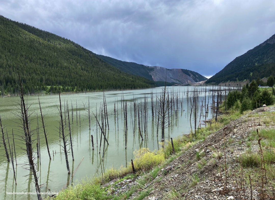
In addition to the cracking of the dam and the shifting of Hebgen Lake, one other event occurred: a landslide. Triggered by the earthquake, a 0.75 mile (1.2 km) wide section of one wall of Madison Canyon came crashing down, traveling at speeds of up to 100 mph (160 kmh). Eighty tons of moving earth covered the bottom of the canyon with more than 200 feet (61 m) of debris.
In addition to burying the highway – and some of the people camped in the canyon – it formed an earthen dam, blocking the Madison River. Immediately, water began to accumulate behind this dam. The terrified tourists ran for high ground in hopes of escape but found themselves trapped. Hebgen Lake had shifted, the water behind the earthen dam was rising, and three large segments of the highway were completely destroyed. The best they could hope for was to remain on high ground, out of reach of the water, until help arrived.
It took a couple days and a lot of first responders, but eventually all the survivors were evacuated. The US Army Corps of Engineers then spent three weeks digging a spillway through the landslide to allow the Madison River to continue flowing and prevent future catastrophic failure of this new earthen dam.
Today, as you drive through the canyon on the reconstructed highway, you’d never guess that such destruction once filled the air. But if you know what to look for, the signs are there.
A trail ascends the giant pile of landslide debris to a memorial boulder, which lists names of those who died. Despite the hundreds of people in the canyon, miraculously, only twenty-eight lives were lost. Nineteen people were buried by the landslide; their bodies were never found. Two were killed when a giant boulder tumbled down a hillside and landed on their tent. A couple people drowned, and the others died of their injuries in the aftermath.


The slope where the landslide began is still barren, more than 60 years later.

Damaged buildings and crumbling sections of road remain.


And behind the earthen dam, created on that fateful night, is Earthquake Lake; 6 miles (9.6 km) long, 120 feet (36 m) deep, and adorned with ghost trees that used to stand on the banks of the Madison River.


This was a very eerie place to visit, but I’m really glad we did.
While Earthquake Lake Geologic Area was our main destination, we also detoured to nearby Cliff and Wade Lakes. Unfortunately, the weather was less than cooperative (a recurring theme of this road trip) so we didn’t get to spend too much time at either lake.


In fact, as the day went on the weather progressively deteriorated. By the time we pulled into our campground late that afternoon, it was raining again with no signs of letting up. Our campsite was muddy and mosquitoey and, quite frankly, we were sick of being wet. This would be our last night out anyway… so we departed the campground as abruptly as we’d arrived and pointed the car toward home.
And we have no regrets.


The Important Stuff:
- Earthquake Lake Geologic Area:
- Located along US Highway 287 in Madison Canyon
- Free to visit
- Cliff and Wade Lakes:
- From US Highway 287, turn south onto Cliff Lake Road and follow signs to both lakes
- Where to stay: Lodging options in the immediate area are limited, given the lack of towns. There are a few here and there. Camping is plentiful; there are campgrounds at Cliff Lake and all through Madison Canyon. Some are first come first served, but most take reservations and fill to capacity in the summer.


Leave a Reply