As you may recall from my previous post, the lead-up to our late-March roadtrip was mired in uncertainty. But, with the forest fire situation much more under control by the end of the week, we were officially settled on a destination: the Black Hills.
So off we went, heading north across the dry, barren plains of Colorado and Wyoming en route to South Dakota. We wouldn’t actually reach South Dakota today, though. We had a stop to make along the way, at a small and geologically bizarre national monument in the northeast corner of Wyoming: Devils Tower.
As we left the interstate and began making our way down the two-lane highway toward the monument, my gaze was fixed on the horizon, eagerly awaiting our first glimpse of this towering rock monolith. Alas, it remained out of sight.
I visited Devils Tower as a kid, and I still had very clear memories of the tower itself. But what quickly became clear is that I’d entirely forgotten the surrounding landscape. My recollection was of a tower sticking up out of the middle of nowhere. And Devils Tower does in fact rise higher than any of its surroundings. But the topography here isn’t as flat as the image that lingered in my mind. In fact, there were still quite a few hills between us and the monument.

The other thing I’d forgotten, as it turns out, is the layers of red rock that are part of the surrounding landscape near the monument entrance.

Once inside the monument, the road encircles roughly half of Devils Tower, crossing the Belle Fourche River and then passing thorough a prairie dog town. We stopped for a while to watch the adorable rodents running around and soaking up the sunshine. You may be able to spot a few of them in the photos below.


Continuing on our way, the tower disappears into the trees until the road circles around, ascends, and finally comes to a stop at the visitor center on the opposite side.
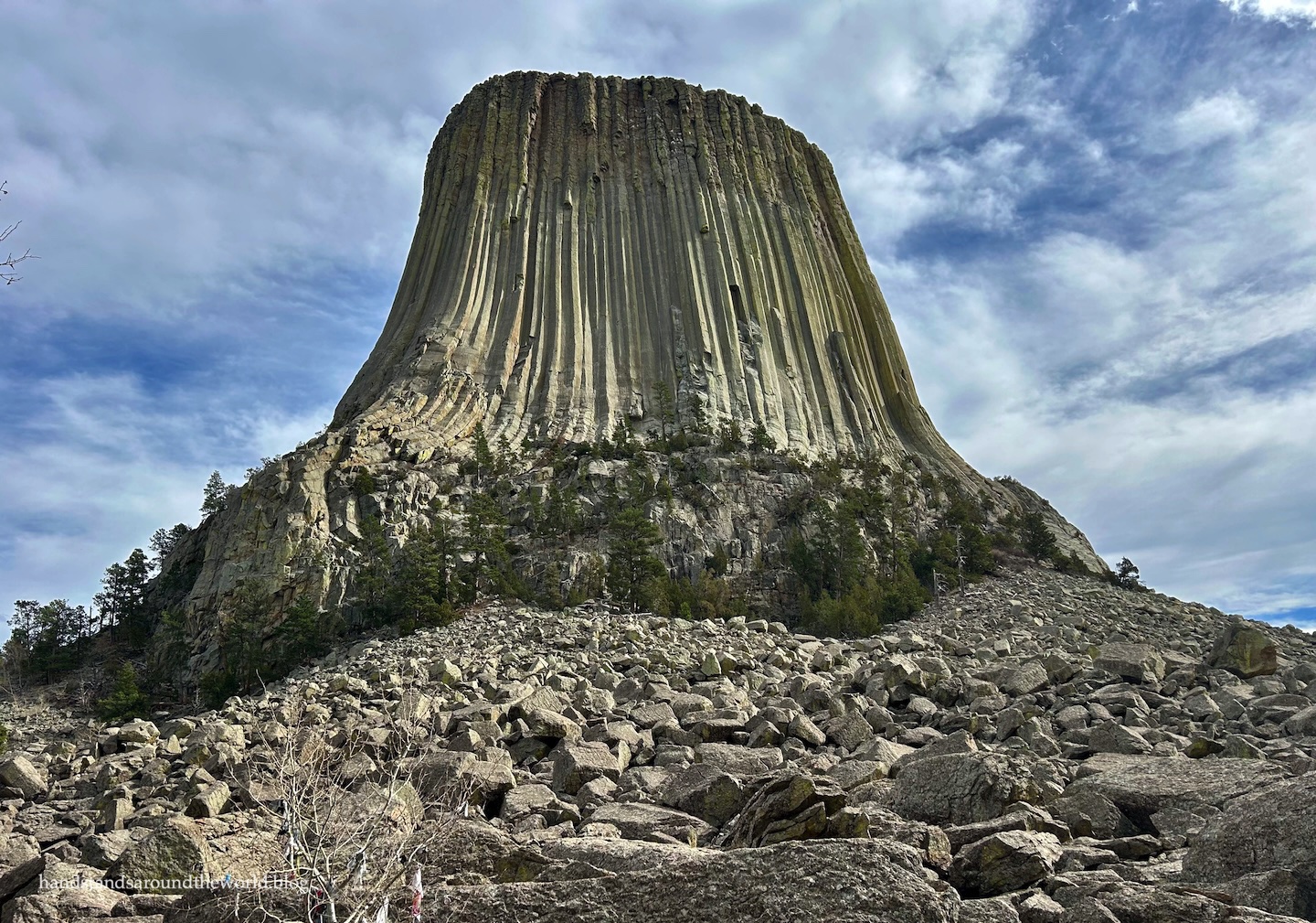
As we’d been driving for hours, upon arrival we decided our first order of business was lunch. It was a bit windy, so we opted for a car picnic instead, complete with an imposing view of Devils Tower.


Right: Pudgey, of course, got her picture taken as well.
There are multiple explanations for the existence of Devils Tower. Geologically, the prevailing theory is that magma from deep within the earth was forced up into a crack in the upper layers, filled the space, and then hardened and eventually cracked into columns as it cooled. Over the subsequent millions of years, the softer surrounding layers eroded away, leaving behind Devils Tower.
The indigenous people who called the Devils Tower area home for thousands of years offer not a geological explanation, but a narrative one: the story of seven sisters who found themselves being chased by a bear and began to run. They came upon a large tree stump and climbed on top of it, hoping for safety. The stump then began to rise into the air, lifting them out of reach of the bear. Even so, the bear tried to reach them, scouring the bark with its claws on its way back down to the ground. The tower was given the name Bear Lodge, and the seven sisters now live in the sky, forming The Pleiades.
Though I’d forgotten the details, the other thing I remembered from my childhood Devils Tower visit is learning these stories. Looking back, I think it’s probably what first sparked my fascination with anthropology.
Anyway. After our lunch with a view, we wandered through the visitor center and then grabbed our water bottles and set off for a short hike. Most visitors to Devils Tower walk the path from the parking lot up to the main viewpoint, perhaps climb around on the boulders a little, and that’s it. Very few venture beyond this point.


We did, and as soon as we did, we left the crowds behind.
Two trails circle the tower: the shorter Tower Trail, which remains close to the base, and the longer Red Beds Trail, which is farther out. We opted for the Tower Trail, which is about a 1.2 mile (2 km) loop. The southern half hugs the base of the tower while the northern half is slightly farther away, and with each curve we found ourselves taking in the tower from a different vantage point. From some angles it’s highly symmetrical, while in others it appears thinner, wider, or leaning slightly in one direction.


We also caught a glimpse of some climbers who were making their way down after summiting earlier in the day. There are multiple climbing routes up the tower, including some that aren’t terribly difficult, and hundreds of people tackle the routes each year. All that’s needed is appropriate gear and a permit from the visitor center.

After circling the tower, we still had a couple hours left in our day, so we decided to check out one of the other trails. Initially, we’d been considering Red Beds, but a park ranger recommended Joyner Ridge Trail – further from the tower, but with very different views and no crowds. That was more than enough to convince us.
The Joyner Ridge Trail is at the end of a short gravel road that branches off the main road not far from the visitor center. It can be hiked as an out-and-back or a loop. We opted for the loop, as the entire distance was just 1.5 miles (2.4 km).


We hiked clockwise, and I think this was probably the right choice. No matter which way you go, you’ll drop down into a low area and have to climb back up. With a clockwise hike, the ascent is closer to the end but much more gradual. Also, you’ll have better views of the tower.


Right: view from the low point of the trail
Since it was March, and daylight hours were still short (and overnight lows should have been below freezing, had it been a normal spring), we opted to stay in hotels this trip rather than camp. Our hotel was about 10 minutes away in the very tiny town of Hulett, Wyoming.
Once we were settled into our room for the night, we didn’t really have any intention of leaving. But as sunset approached and a few clouds filled the sky, we decided it was worth making the short drive back to watch the sun disappear behind Devils Tower.
This was absolutely the right decision.

We pulled over in a roadside parking area just outside the monument entrance and watched as the sun sank down over the horizon and the clouds turned varying shades of yellow, orange, and pink.


It was a lovely way to end our time at Devils Tower.
Up next: a scenic drive through Spearfish Canyon, South Dakota
The Important Stuff:
- Getting there: Devils Tower National Monument is located off WY Route 24 north of Moorcroft. While National Park Service sites are usually well marked with roadsigns, we didn’t find that to be the case here. A maps app should get you here just fine, but be sure to pre-load the directions and screenshot them just in case. There’s little to no phone service here.
- Fees and passes: there is a $25/car weekly entrance fee for the monument, or you can present your America the Beautiful Pass at the entrance station.
- Where to stay: there is a campground in the monument; however, it’s relatively primitive, reservations are not accepted, and it’s only open in the summer.
- Hiking: there are about 10 miles (16 km) of trails in the monument. A monument map, including hiking trails, can be found here. At minimum, it’s worth hiking the 1.2 mile (2 km) trail around the base of the tower.
- Other: Devil’s Tower is very remote. The nearest towns are very small, so amenities such as gas, groceries, restaurants, and lodging are scarce. There’s also very little phone service. Come prepared with everything you need for the duration of your stay. Also, come prepared for any weather. For us, in late March, it was windy and 80°F (27°C). A few days earlier, it had snowed.
Leave a Reply to RebeccaCancel reply