Some people who set out to climb the Colorado 14ers do it ABC: all but Culebra.
Why, you ask?
Because the peak is on private land and the owner charges a fee to access it.
So when my friend invited me to climb Culebra with her (and another friend, who unfortunately had to cancel) this past June, I had a decision to make: am I an ABCer or not?
I understand both arguments. On the one hand, can you really say you’ve climbed all the 14ers if you haven’t actually climbed all the 14ers? On the other, do you want to give an already-wealthy landowner even more money? To be clear, I’m not against an owner charging a fee for people to recreate on private land. It’s their land. They’re under no obligation to allow people to recreate there at all, and if they do, they have to carry liability insurance and they have to maintain the roads and other facilities, and that requires time and money.
If it wasn’t obvious from the fact that this post exists, I ultimately decided that if I’m going to commit to summiting all the 14ers, I’m going to summit all the 14ers.
So I somewhat begrudgingly forked over the $150 and signed up for the trip (the landowners also limit the number of people per day so you do have to reserve in advance).
We arrived at the gates of the Cielo Vista Ranch – which is beautiful, by the way – the night before our hike. The gates open each morning from 6:00-6:15am only, and it was a decent drive, so we opted to camp in the designated area at the edge of the ranch to ensure an on-time arrival.

It was mostly sunny when we arrived, so we set up our tents immediately; this turned out to be fortuitous because within 15 minutes it was raining. So we hunkered down in the car until it mostly let up and then quickly made and ate our dinner under the liftgate. Fortunately, within 45 minutes the clouds began to clear, and by nightfall we had a sky full of stars.


When we’d first arrived, there was a group of 5 guys drinking beer and another 3 with music playing, and I was immediately annoyed that it was going to be another one of those camping experiences. My husband and I had far too many of them last summer (this one definitely takes the cake).
But it wasn’t!
After dinner, all 10 of us ended up sitting around a campfire chatting until about 10:00pm, at which point we all headed to bed, and it was a very quiet night.

It was also a very cold night; I spent it burrowed in my sleeping bag like a burrito with a down blanket wrapped around me. Even so, I slept terribly, although that had less to do with the cold and more to do with the fact that my first night in a tent each summer is always like that.
We woke to crystal clear skies and frost all over everything. Cielo Vista is only open to hikers from January through July each year, most of which isn’t ideal hiking weather; I knew it wasn’t likely to be warm, but I didn’t expect it to be quite so cold.

Despite the cold, we were very lucky. Up to this point, Colorado had the coldest and stormiest June of all time. It snowed in the mountains multiple times while the rest of the state got pummeled with rain. We booked this trip in February, and we’d unwittingly chosen the first nice day all month, with a forecast of sunshine and no chance of storms. So really, I can’t complain too much.
But don’t worry; I’m still going to at least a little.
They opened the gates just prior to 6:00am, so we piled into the car (we were allowed to leave our tents set up until after the hike) and made our way up the road. We stopped for a couple minutes at ranch HQ to check in and receive the safety spiel, and then we were on our own for the rest of the day. All we had to do was stop and sign the checkout log on the way out. Everything on the ranch was well run, which I appreciated.
The road to the trailhead is marked as high-clearance 4WD only and that’s pretty accurate. I’d put tea in a thermos before we left camp figuring I’d drink it as we drove, but it was far too bumpy for that.
Someone did get their Subaru up to the trailhead, but you really have to know what you’re doing. Also, the road was dry and in decent condition; when wet, or if it gets rutted or washed out by weather, it would be a different story. It’s definitely not passable in a sedan or anything with less clearance.
That being said, it’s a lovely drive through a large and very beautiful aspen grove before crossing into pine forest.
The road was open all the way to the upper trailhead, which cut quite a bit of distance off our hike. It had only been open above the lower trailhead for 1-2 weeks, so just know that if you sign up for this hike earlier in the year, it’s longer. Potentially a lot longer if neither trailhead is open and you have to park at HQ.
The hike itself is pretty much a choose your own adventure kind of thing. There is an old road you can follow for a ways, but it heads pretty far west and makes the hike longer, albeit slightly less steep. We opted for the main route, which crosses the creek and then just heads straight up to the ridge. The tundra was just beginning to come alive, the first small flowers blooming and a few marmots and pikas making an appearance. I also saw a small mouse-looking thing; from some quick research, I think was a vole.


The climb to the ridge was brutal, gaining about 1500 feet (455 m) in 1.2 miles (1.9 km). It was steep. It was also our first time at this elevation in months, the ridge never actually seemed to get any closer, we were cold, and the one cloud in the entire sky wouldn’t move out from in front of the sun.
In short, we weren’t super enthusiastic about this hike so far and we both had moments of doubt as to whether we would summit. I’d planned to climb another 14er – or at least a 13er – a week before this hike to acclimate, but the weather didn’t allow it.


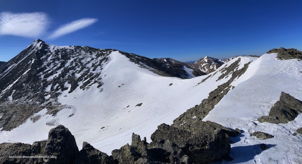
It took us close to two hours to reach the ridge, marked by an enormous cairn at around 13,300 feet (4055 m).


But once we were there, we found ourselves much more energized. The sunshine helped, and so did the fact that we could now see the progress we’d made as well as the summit of Culebra.
Or so we thought.
That high point in the photo above is actually a false summit.
We did know there were a couple because we’d read the route description beforehand, so it helped a little that we were expecting them. We just didn’t realize we were currently looking at one; we thought the false summits were those lower bumps in the ridge. Had we taken time to look at the route description again, we would have realized our mistake.
From here, the rest of the route was clear. We dropped down, climbed back up, and continued along the ridge or adjacent to it for the remainder of the hike. There was still quite a bit of snow, as you can see, but it was largely stable and with our microspikes we had no trouble navigating it.
Actually, it was much easier to walk through the snow than the jumble of rocks. Earlier in the season, though, I can see how the snow would be sketchy. Also, I wouldn’t have wanted to do it without my microspikes.


At last, we crested the false summit and found ourselves staring at the actual summit… which was still close to 0.5 miles (0.8 km) away. I don’t seem to have a photo of it, because right around now was when the wind really picked up.

A chilly breeze had been blowing the entire hike, but that’s to be expected at elevation. Now, we were contending with a frigid wind whipping up the mountainside, the strongest gusts blowing us off balance. It was so bad I actually had trouble holding onto my hiking poles. But we were so close so, miserable as it was, we weren’t going to turn back now.
And we made it!
Most everyone had already summitted and were headed back down, so we had the summit to ourselves for the whole ten minutes we could stand it. We were able to find a little bit of shelter around the back side, but it was still too cold to do much.
I managed a few photos, and I was able to get Pudgey’s summit photo as well, though she had to stay in my backpack so she wouldn’t blow away (seriously, it was that windy). It was too cold to take my gloves off to eat, so I ended up sticking my face into my bag of chex mix like a dog, eating a few bites, and then giving up.


It was a bummer to spend so little time on a summit we’d worked hard to reach, but such is the reality of hiking a 14er. Sometimes you get lucky with beautiful summit weather, and sometimes you don’t.
Luckily, by the time we got back to the false summit the wind let up enough to be not quite so awful. It improved progressively as we descended and the sun gradually warmed as well, and by the time we got back to the cairn it was much more tolerable. I’m thankful, because I’d underestimated just how cold it would be and wasn’t quite prepared. I stayed warm, but just barely; I should have brought my down jacket and my mittens, as my fingers only stayed warm in my winter gloves with the help of handwarmers.

From the cairn, we turned south and began the grueling descent back to the car. It was hard on the knees, but other than that, uneventful. It also really put into perspective just how steep the terrain is, which made us feel much better about how exhausted we’d been on the ascent.

By far, the most fun part of the descent was right near the end, when we got to butt slide down a snow field. The rest of the snow was all easily avoidable, but this section wasn’t. However, it wasn’t too long or steep and therefore presented the perfect opportunity for some fun. If you know how to glissade safely, you could have done quite a bit of it on the upper snowfields. We don’t, so for us it was just this.
Then it was a quick walk through the grass, across the creek, and down the old road back to the car. What took about 3.5 hours to climb took only 2 hours to descend, and we reached the trailhead around 12:30pm. My hiking tracker clocked it at 5.4 miles (8.7 km) with about 2720 feet (830 m) of elevation gain. One thousand vertical feet per hour is often cited as a standard pace on 14ers, so we weren’t too far off that.
Back at the car, we bumped and bounced our way down the road, signed the checkout log as instructed, and then packed up our camp and headed out.


And that’s Culebra Peak.
In summary, I (mostly) enjoyed my 9th Colorado 14er. But next year, I think I’ll wait for warmer weather to start chasing summits.
The Important Stuff:
- Getting there: Culebra Peak is accessed from the north gate of Cielo Vista Ranch, about 8 miles (13 km) west of San Luis, Colorado.
- Fees and passes: the cost to hike Culebra is $150 per person. Spots are very limited; sign up in advance.
- Hiking: since there isn’t an exact route, stats vary from person to person. The route description says 5 miles (8 km) with 2700 feet (823 m) of elevation gain. My hiking tracker said 5.4 miles (8.7 km) with 2720 feet (830 m) of gain.
- Route: a complete and detailed route description can be found here. Before heading off on this hike, download the 14ers.com app and save the text and photos for offline use.
- Where to stay: the easiest option is to pitch a tent in the designated camping area or sleep in your car at the gates of Cielo Vista Ranch. Optionally, there are a few other camping or lodging options in the vicinity, but there aren’t any major towns nearby.
- Other: because this peak is only open the first half of the year, you’ll likely be climbing it in winter or winter-like conditions. Check the weather, the ranch website, and recent trip reports before setting out so you’re prepared for the conditions. Also, the fact that you have to pay to climb can increase summit fever. It’s crucially important to avoid that and be willing to turn around if weather deteriorates or conditions exceed your skill level.
Leave a Reply to travelling_hanCancel reply