I have a terrible tendency to discount shorter or easier or lower elevation hikes because I’d much rather be above tree line on a summit or way in the backcountry at an alpine lake.
I’m certain this bias has caused me to overlook many hiking opportunities over the years. But Colorado continues to remind me that the shorter hikes in the foothills are beautiful in their own right, and I’m trying to include more of them in our weekend excursions.
These hikes in particular are ideal options for winter as they’re easy to access even in snow, usually warmer and less windy than the mountains, and with little to no risk of avalanches. Most of the hikes are fairly short and don’t necessarily warrant an entire blog post of their own, so I’ve decided to group them together by location; today will be about a few different hikes in the Evergreen area that I’ve completed over the last four years.
The quaint mountain town of Evergreen is located about 40 minutes west of Denver down winding back roads. It’s a lovely place, and one that’s surrounded by numerous hiking opportunities. Here are some of the highlights:
Table of Contents
- Evergreen Mountain, Alderfer/Three Sisters Park
- Elephant Butte, Alderfer/Three Sisters Park
- Bergen Peak, Elk Meadow Park
- Independence Mountain, Pence Park
- Panorama Point, Corwina Park
- Genesee Mountain, Genesee Park
- Maxwell Falls
Evergreen Mountain, Alderfer/Three Sisters Park
Evergreen Mountain is an 8500 foot (2590 m) peak immediately west of Evergreen. (There are nearby towns named Pine and Conifer, which should tell you everything you need to know about the forest composition in this area of the state.)
I first hiked to this summit with a friend on a Friday afternoon in April, and right from the beginning we found ourselves navigating quite a bit of mud. There was some lingering snow and ice as we ascended, but nothing we couldn’t navigate with the help of our microspikes. We began at the East Trailhead and followed Evergreen Mountain East Trail to the Summit Trail, then descended along Evergreen Mountain West Trail. It ended up being a lovely loop through beautiful forests and a meadow, leading us past some viewpoints along the way. We also saw a few elk and deer grazing in the meadow.
I repeated this trail this past January with my husband and it was snowier but no less scenic. We followed a slightly different route toward the end, which crossed the road and took us through part of the old Alderfer Ranch. The photos below are from both of these hikes.


The stats: 6.8 miles (10.9 km) | 1070 feet (325 m) elevation gain
Elephant Butte, Alderfer/Three Sisters Park
The newest trail on this list is also in Alderfer/Three Sisters Park but travels in the opposite direction. The trails that connect to the Elephant Butte Trail have been there for a while, but the official trail up the butte was created fairly recently. This past March, C and I set out to hike it.
We began at the West Trailhead, following the Bluebird Meadow Trail to the Mountain Muhly Trail, which is a large loop. We veered off in an attempt to climb the small rocky high point adjacent to the trail, but were thwarted by snow and ice.
Back on the Mountain Muhly Trail we continued through the forest, gradually gaining elevation until we reached the turnoff for Elephant Butte Trail. The path exits Alderfer/Three Sisters and enters Elephant Butte Park.
From a distance, Elephant Butte doesn’t look all that steep… but it sure felt steep when we were climbing it. The trail travels in a fairly straight line almost to the summit, before curving 180° for the final push to the top. There was a small fire on the summit in 2020, and the trail travels right through the burn scar. It was windy so we were cognizant of the burned trees, which are weakened and prone to falling over.


The stats: 6.2 miles (10 km) | 1310 feet (400 m) elevation gain
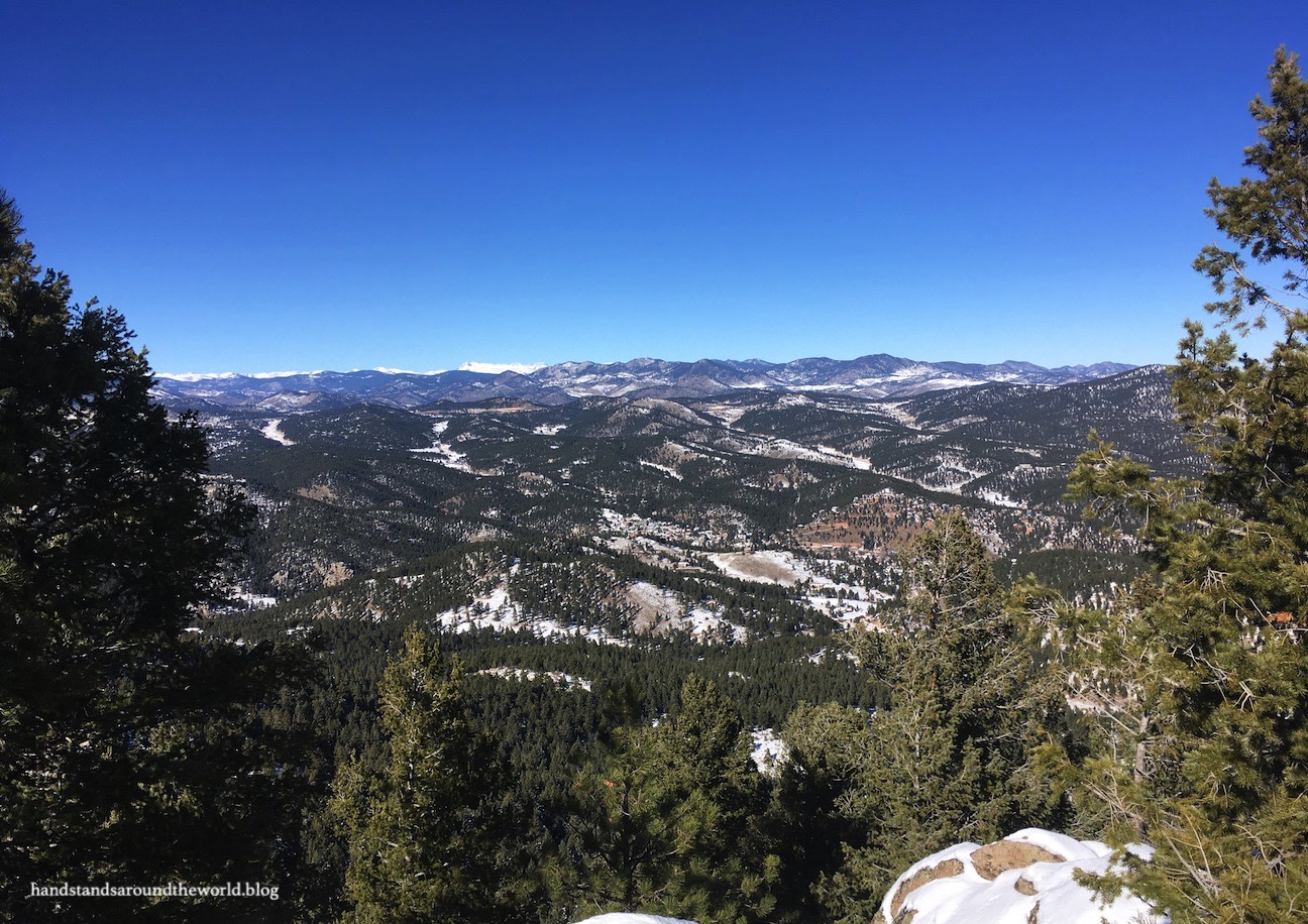
Bergen Peak, Elk Meadow Park
Bergen Peak is a 9700 foot (2960 m) summit located on the westernmost edge of Elk Meadow Park. Part of the trail also passes through the Bergen Peak State Wildlife Area (for which a permit is now required). I really enjoyed this hike, especially with everything turning green after the world’s longest winter finally gave way to spring. Bergen Peak is also a decently tall mountain for this region of the foothills, and it’s certainly the longest and most difficult hike on this list.
A friend and I began at the Elk Meadow Park South trailhead, following the Sleepy S Trail to Elk Ridge Trail, which brought us to the Bergen Peak Loop that climbs around and up to the summit. We descended via the other half of the loop, which brought us to the Meadow Trail that we then followed back to the car. Despite all the trail changes, everything is well marked and navigation is straight forward.


More recently, I summited Bergen Peak this past February with C. This was actually our second attempt; our outing the previous winter ended with us knee-deep in the snow almost 3 miles (4.8 km) shy of the summit. We hadn’t packed our snowshoes and didn’t feel like postholing for 3 miles. We didn’t pack our snowshoes on attempt #2 either, but this time we didn’t need them. The trail was well-packed all the way to the summit and the weather was decent as well.


The stats: 10 miles (16 km) | 2280 feet (695 m) elevation gain
Genesee Mountain, Genesee Park
After C and I bailed on Bergen Peak the first time, we decided we weren’t quite ready to be done with our day. We had some trouble figuring out where to go that wouldn’t be covered in just as much snow, but eventually settled on Genesee Park. From the parking area, it was less of a hike and more of a short walk up to Genesee Mountain Summit. After not summiting Bergen Peak, it was nice to stand on a high point in the sunshine and enjoy some views.


The stats: 1.5 miles (2.4 km) | 235 feet (72 m) elevation gain
Panorama Point, Corwina Park
These next two hikes were actually completed in the same day. Corwina Park is one in a string of Denver Mountain Parks located along Highway 74 in the foothills east of Evergreen. There are multiple trails in these parks and I’d like to return and explore some more of them. But our destination on this particular day was Panorama Point.
It was the morning after a late November snowstorm… the sixth such storm in as many weeks. But the sky had finally cleared the previous afternoon and it was forecast to be a sunny, warm day so we headed out early to beat the crowds and enjoy the snow-covered landscape.
There was about 4 inches (10 cm) of fresh powder and the park was relatively untouched; a couple sets of footprints marked the trail, but that was about it. So we followed the tracks up and around to Panorama Point, spotting a couple deer along the way and periodically getting hit in the head with bits of snow falling from the trees. Panorama Point is an aptly named destination, with spectacular views of Mount Blue Sky. And in the foreground of the photo below was our next destination: Independence Mountain!

The stats: 2.5 miles (4 km) | 650 feet (200 m) elevation gain
Independence Mountain, Pence Park
After descending from Panorama Point we drove up the road to Pence Park, located just off Myers Gulch Road about 5 minutes from our previous trailhead. This is a shorter but steeper hike, climbing about 750 feet (230 m) in 0.9 miles (1.5 km). The beginning of the trail is a loop; we ascended via the southern half, which is slightly shorter but also steeper, and descended via the northern half.
From the top of Independence Mountain (the unofficial summit, since the actual summit is private property) we could see downtown Denver and the surrounding mountains, painted in white and glistening beneath the early afternoon sunlight.


The stats: 1.8 miles (2.9 km) | 750 feet (230 m) elevation gain
Maxwell Falls
The Upper Maxwell Falls trail departs from an unmarked pullout on Black Mountain Drive south of Evergreen. The falls can also be reached from the lower trailhead but it’s a much longer hike from that direction. A friend and I started our hike early in the morning the day after a small snow storm and had the trail almost to ourselves for the entire hike. The falls was completely snow-covered so we didn’t actually see it. But we completed the entire loop trail and really enjoyed the beauty, solitude, and views! It’s a place I’d like to return to one spring when the snow is melting and the waterfall is flowing at its peak.


The stats: 3 miles (4.8 km) | 515 feet (155 m) elevation gain
Leave a Reply