Southwestern US, US National Parks

“It’s a helluva place to lose a cow” – Bryce Canyon National Park, Utah (part I)

Thank you to Ken Burns’ The National Parks: America’s Best Idea documentary series for this gem of a quote. If you haven’t watched this series, I highly recommend it. We really enjoyed it!

The quote is attributed to Ebenezer Bryce, a Mormon pioneer who homesteaded near Bryce Canyon in the 1860s and began taking visitors on tours. Eventually it became known as Bryce’s Canyon, a name which was retained (minus the possessive) when it was designated a national monument in 1923.

Bryce Canyon would indeed be an unfortunate place to lose a cow. Or any other animal. Or yourself. An approximately 60 square mile (155 square km) maze of red rock hoodoos, Bryce is my favorite of Utah’s “mighty five.” It’s a place I’ve been eager to return to since my first visit with my family back in 2005. We barely scratched the surface on that trip, and Pat had never been to Bryce at all. It was high time to remedy that, and Thanksgiving break was the perfect time to do so.

It was a loooong drive from Denver to our hotel in Bryce Canyon City, made even longer when we got stuck behind a semi going 40 mph that decided to pass a semi going 39 mph (in an area where the speed limit was 75 mph). At one point, we also travelled through a 110 mile (177 km) stretch of I-70 with no services, including gas. It’s important to plan ahead when driving across Utah, as there are vast expanses of nothingness. It’s wild and beautiful nothingness. But if you run out of gas, food, or water, you’ll be out of luck (and probably also out of phone service).
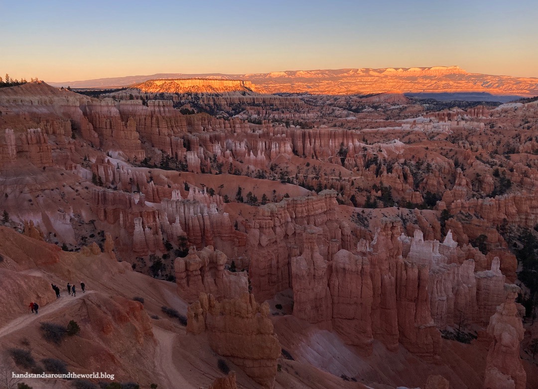
Heading west out of Denver at sunrise
I-70 enters the San Rafael Swell in Utah
Atop the San Rafael Swell

After about 9 hours of driving, we arrived in Bryce Canyon City just in time to drive into the park and watch the sun sink below the horizon from the appropriately-named Sunset Point.

Sunset at Sunset Point

On each of the next two mornings, we were up fairly early and headed into the park for a day of sightseeing. (But first, I want to give a shout-out to Ruby’s Inn in Bryce Canyon City, at which our “continental breakfast” consisted of a voucher for the all-you-can-eat buffet at the on-site restaurant. Highly recommend.) Rather than write about things in the order in which we saw them, I’m going to mix and match over the course of this post and the next one so I can group similar things together. For today, the focus will be predominantly on sightseeing from the rim of Bryce Canyon.

We began at the visitor center, which contains exhibits explaining the history of the region, geology of the hoodoos, the flora and fauna we might see, and what to expect as we made our way through the park.

Our strategy for seeing the park was to drive all the way to the end of the road and work our way back, as this is the opposite of what most people do and allowed us to avoid the crowds a little. All the way at the end of the 18 mile (29 km) Scenic Southern Drive is Yovimpa Point, Rainbow Point, and the Bristlecone Loop Trail. From the visitor center, it took about 30 minutes to reach the end of the road.

Yovimpa Point

We were excited to see bristlecone pines, so after taking in the views we bundled up and set off on this 1.3 mile (2.1 km) loop along the canyon rim. And honestly… it was kind of a bummer. The largest bristlecones were dead – or at least, they looked dead – and the smaller ones just looked like any old pine tree. I’ve seen better in multiple other locations. I probably wouldn’t recommend this trail, at least not for the trees. The views were nice, though.

Views from Bristlecone Loop

From here, we began making our way back toward the park entrance, stopping at the many viewpoints along the way.

Black Birch Canyon
Ponderosa Canyon
Natural Bridge
Piracy Point

Our second hike of the day, departing from Bryce Point, was to the Hat Shop, a small collection of hoodoos topped with precariously-balanced rocks. These are called cap rocks. A cap rock is a rock that is harder than those beneath it, resulting in erosion of the layers below while it remains mostly intact. As the layers erode away, the cap rock is left balanced on top… until eventually so much erodes beneath that it topples to the ground. We saw some of each at the Hat Shop.

This was also our first venture down into one of the amphitheaters. This section of trail (called the Under-the-Rim trail) isn’t in the main amphitheater and we didn’t have too many up-close views of the hoodoos from here. However, it was a neat hike and we only saw about five other people on the trail, so if you’re looking to get off the beaten path in Bryce Canyon I would recommend this hike. I’d rate it as moderate-difficult; 4.6 miles (7.4 km) round trip with 1150 feet (350 m) of elevation gain, much of which is at the end as you climb back up to the rim.

Under-the-Rim Trail
The Hat Shop

Back at the trailhead, we enjoyed the view from Bryce Point.

Bryce Point

Next was Inspiration Point, which ended up being my favorite view. Walking up to the edge and gazing down at a 180° vista containing thousands of hoodoos filled me with a sense of awe that’s hard to describe.

Inspiration Point
Fairyland Point

One final hike, completed as we were departing Bryce Canyon, was to Mossy Cave. Which is, as the name suggests, a cave filled with moss. In the summer, there’s also water dripping down. The water originates in an underground spring and is responsible for the erosion that created the cave. As it was November, most of the water was frozen.

The Mossy Cave trail departs from Utah Highway 12. It’s about a 10-15 minute drive from the main part of the park out to this trailhead, so this makes a good stop on the way into or out of Bryce Canyon. From the parking lot, it’s a short 0.8 mile (1.3 km) hike along a creek to Mossy Cave. The final climb to the cave is steep and may be icy in the off-season.

Hiking to Mossy Cave
Mossy Cave

And this is where I’ll leave off for now. Stay tuned for next week’s post in which I’ll talk more about the geology of Bryce Canyon and our hikes down into the main amphitheater of hoodoos.


The Important Stuff:

  • Getting there: Bryce Canyon is located on Utah Highway 12 in southwestern Utah; any maps app should get you there
  • Fees and passes: there is a $35/car park entry fee that’s good for 7 days; interagency and annual passes are accepted (more info here)
  • Hiking: There are dozens of miles of trails within the park, ranging from simple walks along the rim to steep descents into the hoodoos; an overview and list of the hiking trails can be found here
  • Where to stay: In the summer, there are 2 campgrounds and a lodge within the park, in addition to campgrounds, lodges, and hotels immediately outside the park in Bryce Canyon City and a few miles further away in the towns of Tropic and Panguitch. In the off-season, many of these are closed and options are much more limited. We stayed at Ruby’s Inn in Bryce Canyon City (about $90/night in the off-season) and would do so again
  • Other: Given the surrounding desert-like environment, it’s easy to forget that Bryce Canyon is a high elevation park. The canyon rim ranges from 8000-9000 feet (2440-2740 m) above sea level. Summers are hot with intense sunlight and afternoon thunderstorms. Winters are cold and snowy. Come prepared for exposure to the elements, keep an eye on the weather, and remember that the air is thinner up here, making hiking more difficult

67 thoughts on ““It’s a helluva place to lose a cow” – Bryce Canyon National Park, Utah (part I)”

  1. Firstly – what a great blog post title! Haha. I’m so gutted we didn’t make time to go to Bryce Canyon, it looks totally stunning and your photos are fantastic. Natural Bridge looks lovely. Also lol’d at the Hat Shop, is that its actual name?! That’s brilliant.

    Liked by 1 person

  2. Beautiful photos, and nice to see some of the other parts of the park. The Hat Shop is well named! I had no idea there were bristlecones there, though it does make sense now I think about it. I remember the ponderosas quite vividly – it was the first time we’d seen them. That quote from old Ebenezer has stuck with me ever since we visited the park in 1999 🙂

    Liked by 1 person

  3. Thanks for the chuckle on your article title. I love the history, and with so many twists and turns, I can see why a guide would be needed. Thank goodness for GPS now.
    Your photos are simply stunning. I bet you have about 1,000 more that you could have also used. I can see why you chose to come back here specifically and spend some quality time.

    Liked by 1 person

    1. Oh, and I had to laugh about you being stuck behind a slow vehicle. We drove to Moab years ago in our VW Vanagon campervan. Something was terribly wrong with the engine, and we could barely do 50 km/h. Going up and over some of those high passes was excruciating as we just weren’t sure we would make it. At the top, we would stop to let both the van and my husband blow off steam, before we started off for the next section. Our van spent a week in the shop in Moab while we canoed the river.

      Liked by 1 person

      1. Oh no! That sounds terribly stressful. I wouldn’t have been annoyed if it was a struggling car… it was the fact that one semi decided to pass another semi, leaving us unable to go around either of them for close to 5 mins. Very frustrating.

        Like

  4. I love your title (and the original comment by Mr. Bryce)! We have done that drive, and it does get looonnnggg. The first time we did it was in the ’80s, so no cell phones anyway, and I was terrified we’d run out of gas or have a breakdown somewhere out there in the long patch of nothingness. Bryce is in my top 2 in Utah (I might put Zion first), and your post and photos brought back great memories. I assume Pat enjoyed his first trip there!

    Liked by 1 person

    1. He did enjoy it! I can imagine driving that long stretch of highway would be stressful without a cell phone, especially nowadays that we’re so used to always having one. Glad to hear you didn’t break down on the way.

      Liked by 1 person

  5. Love the quote, an old one. My housemate took a picture book of American national parks to Morocco in 1968 and the chapter on Bryce highlighted the “tough place to lose a cow” quote. The quote immediately stuck in my mind as both evocative of the terrain as well as the down to earth point of view of the settler. I haven’t visited Bryce. The closest I’ve been to similar erosional scenery are North Dakota and Alberta badlands, various hoodoo mountainsides in B.C., and the karst chaos of Montpellier le Vieux in the “causes” of Bas Languedoc, of which I’ve posted a few undistinguished pics on my blog. Definitely not on the same scale, though had I had a bit more time on my Saharan crossing I might be telling a different tale. The scenery in Bryce is wondrous. Hope no one ever opens a coal mine there!

    Liked by 1 person

    1. Interesting. I’ve been to the Badlands as well, but never to anywhere else like Bryce. I’m going to look up the other places you mentioned as I’m not familiar with them. I’m certainly glad Bryce is protected so no one will be able to exploit it for resources.

      Liked by 1 person

    1. We didn’t this time but I went there about 10 years ago. It’s a nice park and I remember we enjoyed the campground. I have a post about it somewhere back in the archives of my blog if you wanted to see some photos.

      Liked by 1 person

    1. That is funny! You guys could do a pretty epic Utah national park road trip. I know my mom would jump on the chance to come with you, she loves Utah.

      Like

  6. Oh My Goodness, this is absolutely INCREDIBLE. Your photos are just insanely beautiful so I can only imagine what it was like in person. 9 hours seems a very long drive, but sooo worth it for those landscapes. Thank you for sharing, and adding it to the bucketlist for sure 🙂

    Liked by 1 person

    1. It’s a must see for sure. All of Utah, really, is so colorful and unique and worth a visit… but this is definitely one of the best spots in the state in my opinion.

      Like

  7. Ah, Bryce Canyon was the highlight of my road trip last October. Such an iconic national park of the US. I only had a half day there from Zion, and despite some light snowfall, there were CROWDS of visitors (was it the same for you?). Despite some of the roads and viewpoints closed off due to snow, so many people still wanted to visit! Didn’t do any hikes there, but we just drove to the major points (Bryce Point, Paria Point, and Inspiration Point) to admire the views. The hoodoos are truly something, and I can’t wait to see you discuss them in the next post!

    Liked by 1 person

    1. Too bad you didn’t get to spend more time in Bryce (on the other hand, now you have a reason to go back!). There were definitely crowds at the main overlooks and on the easier hikes, but by getting a sunrise start and venturing a little further, we managed to get away from the masses. When we went to Arches and Canyonlands the previous November, I was shocked at the crowds. I had no idea so many people went to national parks in the off season… but this year I was expecting crowds so I wasn’t as surprised to see them.

      Liked by 1 person

  8. One of favourite places on earth, I had long dreamed of visiting Bryce, before we made it there in 2018. We went in late January, when crowds were down, temps were cooler and there was a light dusting of snow on everything. Thanks for the memories Diana. Allan

    Liked by 1 person

  9. Your pictures are stunning. I love all the interesting rock formations. Utah has been high on my list of places to visit for quite some time. The scenery looks beautiful and there are so many great hiking opportunities. It seems like the perfect place to take a road trip.

    Liked by 1 person

  10. I like your expression of “beautiful nothingness” very much (we also have that here in some parts of South Africa and if you don’t mind, I might just use this in future posts 😊). Wow, you have really spectacular photo’s … Sunset Point is amazing and I love the natural bridge. Nature is surely giving you a wonderful exhibition at Bryce Canyon!

    Liked by 1 person

  11. The Bristlecone is a odd tree that seems to thrive in the worst conditions imaginable. They don’t grow naturally in my part of the world – the Canadian Prairie – but they are perfect for our climate. I was so taken by them that I searched extensively to find one in a pot that I could plant at home. I eventually found a tree nursery that had one or two and bought it. It was tiny and all reports I read said it’s a slow growing tree. I planted it in my front yard. Each year it’s grown several inches and it’s getting quite big. I’m certain that nobody else in Edmonton, a city of around one million people, has a Bristlecone in their front yard. In fact I have only seen a couple of them anywhere else in the city. Some day, when crossing borders is easier, I hope to visit a place where I can see “wild” Bristlecone trees.

    Liked by 1 person

    1. How cool, I’ve never known anyone who has a bristlecone growing in their yard. There are a few bristlecone groves here in Colorado and I know of a couple others in Utah and one in Nevada as well. I think California also has some… you will certainly have some options of places to see them.

      Liked by 1 person

    1. Thank you! I agree… while the Grand Canyon is vast and colorful, it definitely is very different from Bryce. I imagine it was amazing to see the Grand Canyon from the air though.

      Like

Leave a Reply

Fill in your details below or click an icon to log in:

WordPress.com Logo

You are commenting using your WordPress.com account. Log Out /  Change )

Twitter picture

You are commenting using your Twitter account. Log Out /  Change )

Facebook photo

You are commenting using your Facebook account. Log Out /  Change )

Connecting to %s

This site uses Akismet to reduce spam. Learn how your comment data is processed.