Due to the pandemic, entrance into Rocky Mountain National Park was a little more complicated in 2020. In addition to a fee or pass, one needed to reserve a timed entry permit. This allowed the park to reduce the number of visitors and spread them evenly throughout the day to better facilitate social distancing.
Plenty of people were up in arms about it, but I actually found it to be a pretty seamless system and fully supported the efforts to reduce crowding. Plus, if you arrived before 6:00am or after 5:00pm, you were exempt from the timed entry system. (Update: permits are still required, though the times have been slightly altered… more info here.)
The downside is that you do have to plan ahead a bit… something my mom and I somewhat failed to do. We needed to visit the park to pick up our permit for an upcoming backpacking trip, and figured if we were gonna drive all the way up there we might as well do a hike too. But we didn’t feel like waking up early and entrance permits were sold out.
Fortunately, there are a handful of hikes just outside the park that are pretty spectacular too. We settled on Lily Mountain. The trailhead is located along CO Highway 7 about 6 miles (9.7 km) south of the town of Estes Park. It’s not marked with any signs but there are a couple pullouts along the road and the maps app on your phone should get you there without issue. As with most Colorado hikes, arrive early to secure parking. It was the middle of the week but the parking area was overflowing by about 11:00am.
This was a fairly short and quick hike for us. It’s only 2 miles (3.2 km) each direction with about 1150 feet (350 m) of elevation gain. The first mile is rather leisurely while the second is where most of the elevation gain occurs. It was a bit steep in places, and definitely challenging for some of the out-of-towners we passed who weren’t used to the elevation. The final stretch to the summit involves scrambling over some decently sized boulders; I have to assume this was a struggle for the dogs and small children we saw.


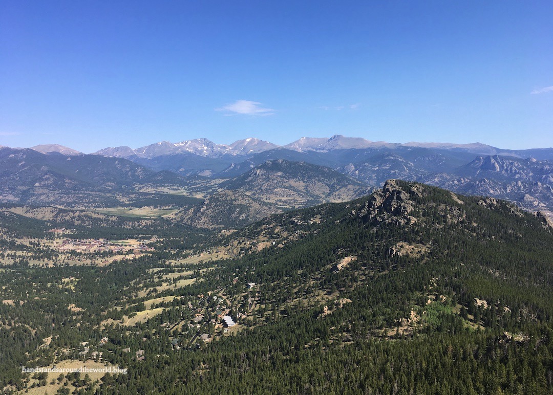
But once you make it to the top, it’s definitely worth it! 360º views greeted us. North is the town of Estes Park. East is the Colorado plains. South is Longs Peak, the highest summit in Rocky. And west is the recognizable profile of the Continental Divide cutting through the center of Rocky. These are mountains we’re very familiar with and it was fun to identify them from a distance and point out all the locations we’ve hiked to.


And that pretty much sums up Lily Mountain. We headed back to the car, popped up to the Rocky visitor center to pick up our permit, and headed home, already excitedly talking through the last-minute details of our backpacking trip.
Next week’s post will be all about that trip, complete with lots of pretty pictures!
The Important Stuff:
- Getting there: the Lily Mountain trailhead is located along CO Highway 7, about 6.5 miles (10.5 km) south of Estes Park.
- Fees and passes: none.
- Hiking: 4 miles (6.4 km) round trip with 1150 feet (350 m) elevation gain.
- Where to stay: lots of options here; there are hotels, cabins, rentals, and campgrounds in Estes Park, campgrounds in Rocky (reservation required), and a handful of Forest Service campgrounds nearby.
- Other: this was a dry, sandy trail with only partial shade; plan for a hot hike, wear good shoes, and pack lots of water.
Leave a Reply to Jet EliotCancel reply