“I’m pretty sure I already know the answer to this, but how do you feel about hiking 14 miles in one day?” I asked my husband as I was assembling our Zion itinerary.
Predictably, he wasn’t enthused.
To be honest, I don’t love hiking 14 miles (22.5 km) in one day either. It’s something I’ve only done a handful of times, and I’m always beyond exhausted by the end.
But sometimes the destination is worth the effort and, as one of the largest natural arches in the world, we decided Kolob Arch was one such destination.
Kolob Arch is located in the northern Kolob Canyons section of Zion National Park. It’s a lesser visited area of the park but, even if you don’t feel like hiking 14 miles, I think it’s still worth spending a couple hours here.
For one, it’s substantially less crowded.
For another, it’s different than the main Zion Canyon section. While at first glance the canyon walls may look the same, the rock in Kolob Canyons is a much deeper shade of red. Add in the bright blue sky and the lush green vegetation that was flourishing after spring rains, and you have an overview of our introduction to Kolob Canyons.

From the Kolob Canyons Visitor Center, located off I-15 south of Cedar City, Utah, Kolob Canyons Road climbs out of the valley and curves around into the canyons. It was early still, and the sun had not yet crested the canyon walls; it was cold as we wove our way along the scenic drive to the Lee Pass Trailhead and the start of our hike.
We parked, climbed out of the car, realized there’s no bathroom at the trailhead, and promptly got back into our car and headed about a mile (1.6 km) down the road to the bathrooms at the picnic area.
Back at the trailhead, we found ourselves putting on earbands and gloves, and I even pulled on my puffy vest. The clouds that dumped cold rain on us the previous day had cleared, but the low temperatures lingered. It’s so easy to forget how cold it can be in the desert!

Fully bundled up now, we set off on the La Verkin Creek Trail. The trail starts high on the canyon walls and immediately begins a steady descent.


Within the first mile (1.6 km), we had descended about 550 feet (170 m) and were now paralleling Timber Creek. The trail proceeded to cross the creek a handful of times. Thankfully the creek was small and shallow – easy enough to jump or rock hop across – as there were few, if any, bridges.

After another 2.5 miles (4 km) and 400 feet (120 m) of elevation loss, the trail curves around to the east, leaving Timber Creek behind and catching up to La Verkin Creek, which we would be following for most of the rest of the hike.
The majority of the descent out of the way, we were now on a relatively flat path as we headed deeper into the canyons.


The canyon is much wider here and the warmth of the sunlight was finally hitting our skin. It was also shining down on the canyon floor, illuminating the lovely greenery – and a few bright pink cactus flowers.
At one point, we saw a particularly brilliant collection of flowers and stopped to take some photos. I knelt down, lined up my shot just so, pushed the button… and a butterfly flew right into the frame!
He’s a little out of focus, but it’s still one of my favorite photos of the entire trip.


After following La Verkin Creek for approximately 2.5 miles (4 km), we reached a junction, marked by a sign and a hitchrack.


Once on the Kolob Arch Trail, we found ourselves navigating very different terrain. While the La Verkin Creek Trail is largely flat, wide, and easy to follow, the Kolob Arch Trail is narrow and riddled with obstacles, ranging from rocks to giant tangles of logs and tree roots (right photo below).


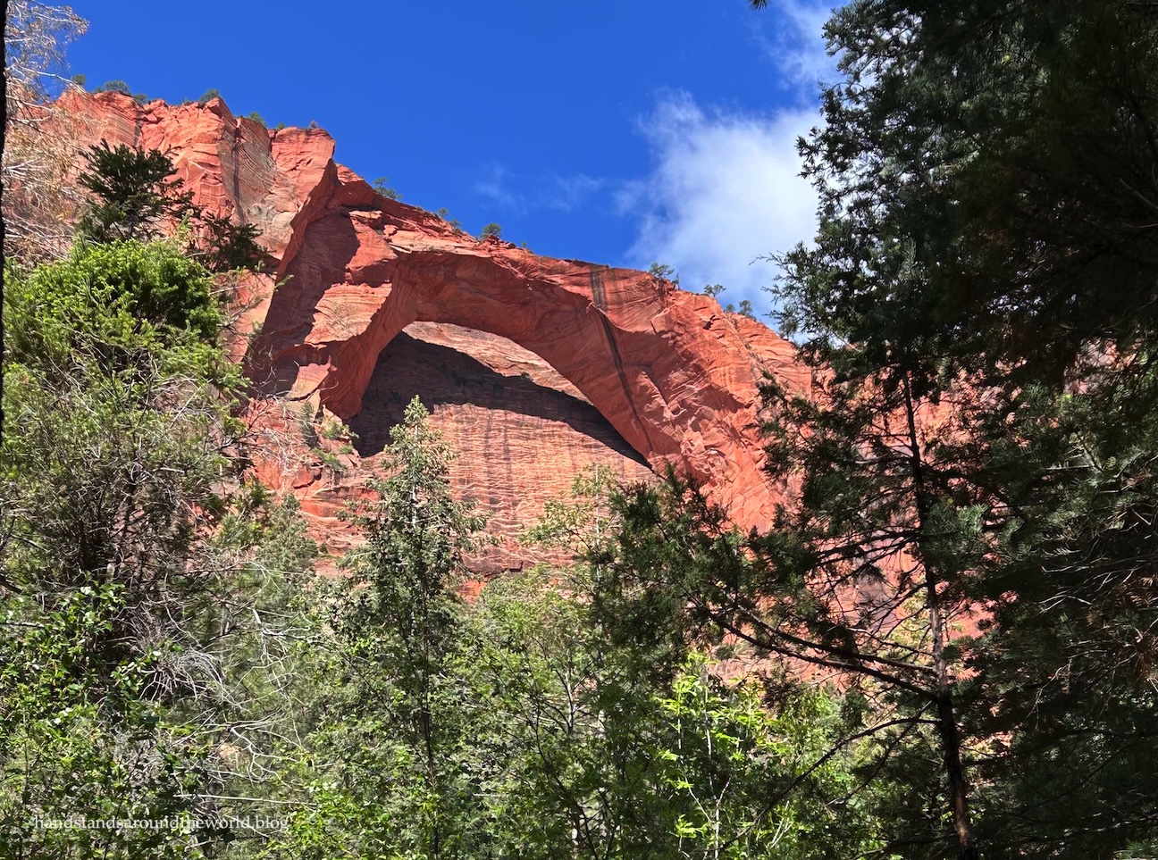
After about 0.6 miles (1 km), during which we gained about 100 feet (30 m) of elevation, Kolob Arch finally came into view.
It’s huge!
It’s also far away, something I failed to realize during my pre-trip research. I was a little bummed it wasn’t closer, but given the terrain between us and the arch, I can see why the trail stops where it does.


Kolob Arch measures 287.4 feet (87.6 m) long, making it the sixth longest natural arch in the world. This puts it just a couple feet shorter than Landscape Arch in Arches Natural Park. However, Kolob Arch is much thicker.
After having a snack at the viewpoint, it was time to retrace our steps down the Kolob Arch Trail and along the La Verkin Creek Trail back to the trailhead.
Of course, that meant our hike ended with an ascent. About 550 feet (170 m) in the last 1 mile (1.6 km), to be precise. After having already hiked 13 miles (21 km), our legs were not amused.

Despite the slight disappointment that came with only seeing the arch from afar, I’m glad we did this hike. Even from a distance, the immense size of the arch is impressive. And we really enjoyed getting off the beaten path and away from the crowds. We only saw a couple dozen people the whole day. I’m pretty sure we saw more lizards than humans.
That being said, it’s a lengthy hike, and not one I feel the need to do again.
Kolob Arch: been there, done that.
Now, it was time to head to our campsite, pick up our permit, and rest up in preparation for our hike the following day.
Up next: hiking The Subway in Zion National Park
The Important Stuff:
- Getting there: the trail to Kolob Arch begins at Lee Pass Trailhead in the northernmost Kolob Canyons section of Zion National Park. Note that this section is off I-15 Exit 40, roughly 1 hour from the main Zion Canyon section of the park. Kolob Canyons Road is paved and any vehicle should be able to make the drive.
- Fees and passes: though there is no entrance station, a Zion National Park entry fee ($35/car for 7 days) or America the Beautiful pass is required. If you have the pass, you can hang it from your mirror. If you don’t have a pass, stop at the visitor center to pay the entrance fee.
- Hiking: roundtrip distance for this hike is approximately 14 miles (22.5 km) with 1950 feet (595 m) of elevation gain. The majority of this gain is on the final 2-3 miles (3.2-4.8 km) of the hike as you climb from the creek back up to the trailhead.
- Where to stay: there is no campground in the Kolob Canyons section of Zion. There are, however, 10 backcountry sites along this stretch of La Verkin Creek Trail (Zion Overnight Wilderness Permit required). Sleeping in your car at the trailhead or camping outside of an established campsite is not allowed in Zion National Park. There are also various lodging options just outside the park in Kanarraville and a little further away in Cedar City.
- Water: the rivers and streams in Zion National Park are contaminated with toxic cyanobacteria and the water is not safe to drink, even with treatment or filtration. Be sure to pack adequate water for such a long hike. Between the two of us, we were carrying six liters of water plus a liter of gatorade. It wasn’t a particularly hot day, and we still finished almost all of it by the end.
- Other: while this is a long hike, it’s not terribly difficult. The biggest challenge is the length. Also, there’s very little shade or protection from any type of weather. If you plan to hike this trail, start early and be prepared to be fully self-sufficient for the entire day. We’re pretty fast hikers and acclimated to the elevation, and this hike still took us nearly 7 hours.
Leave a Reply to travelling_hanCancel reply