As you’ve been reading about for the last month, this summer’s eight-day roadtrip took us on a loop from Colorado to northwestern New Mexico and then across the border into northeastern Arizona. The largest chunks of time were spent in the four parks and monuments I’ve already covered, but we also made a few shorter stops along the way which I’m going to lump together here.
Upon our departure from Chaco Canyon, we stopped at Bisti Badlands and Aztec Ruins National Monument en route to Mountain View Campground and RV Park in Aztec, New Mexico. Or, at least, it calls itself a campground and RV park, though the former is only true if we’re being generous and the latter is absolutely misleading.
We arrived to find a steep, rutted, winding dirt path up to the top of the hill, with sites marked by numbered posts. Each site was equipped with… nothing. Not even a picnic table. A single porta-potty and overflowing trash cans sat just up the road from our “campsite” and there was a water spigot way back down by the entrance.
And that was it.

I’m sorry, but if you don’t even provide picnic tables, you don’t get to call yourself a campground.
Thank goodness we had a portable table and camp chairs with us, and that we always carry plenty of extra water. It was neither comfortable nor convenient, but we were able to make it work for a night.
The couple who showed up with their truck towing a fifth wheel, however, had a much worse time of it. It took them quite a few tries just to maneuver the steep road and tight curves and make it into their campsite. I would not recommend camping here at all, but I certainly wouldn’t recommending doing so with a camper or RV.
At least the mountain view part of the name was accurate.


Table of Contents
- Aztec Ruins National Monument
- Bisti Badlands
- Hubbell Trading Post National Historic Site
- Navajo National Monument
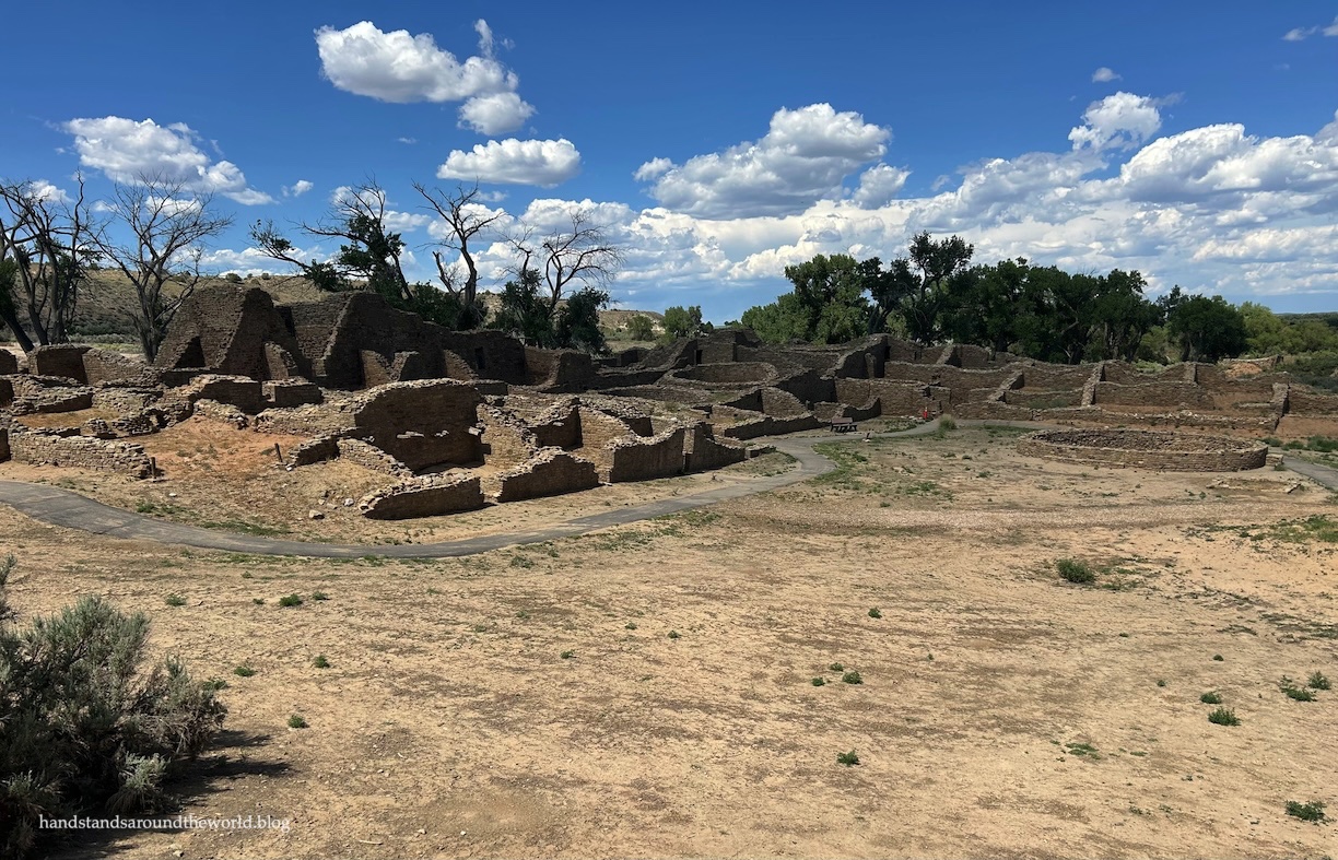
Aztec Ruins National Monument
Aztec Ruins is a poorly named national monument, as the ruins it preserves were built by the Ancestral Puebloans, not the Aztecs. It turns out that Spanish explorers incorrectly applied the name Aztec to dozens of sites throughout the southwest. Many have since been renamed, but this one hasn’t. Also, we learned that to modern day Puebloans, the site is not a ruin, but rather a place where the spirits of their ancestors remain.
The structures at Aztec Ruins were built about 700-900 years ago. Today, twenty-six Pueblos trace their ancestry back to these Ancestral Puebloans and, depending on who you ask, you’ll find many stories about this large three-story pueblo and its meaning. One common thread in these stories is the connection between the spiritual and physical worlds, as seen in the alignment of the walls with the sun, moon, and other astronomical bodies and phenomena. Another commonality is that Aztec Ruins was a place of great importance; it’s thought to have become a cultural and ceremonial center for the Ancestral Puebloans in the post-Chaco area.
The pueblo once contained over 400 rooms, multiple kivas, and a great kiva. While the architecture is in many ways similar to other Ancestral Puebloan sites throughout the region, the Aztec pueblo contains a horizontal band of green rock in some of the walls.


Aztec was occupied from about 1100-1290 CE, after which it sat empty until it was excavated. Half-excavated, I should say. The Aztec West Pueblo can be viewed from a 0.5 mile (0.8 km) self-guided trail, but Aztec East and at least one other compound remain unexcavated.


In addition to walking the trail, we ate lunch at the picnic area, watched the informational video in the visitor center, and toured the museum. In total, we spent about two hours here; it was a nice quick stop to end our day.
The Important Stuff:
- Getting there: Aztec Ruins is located within the town of Aztec in northwestern New Mexico. Signs and/or a GPS app should get you there without issue.
- Fees and passes: none.
- You can find additional information such as hours of operation (the park is not open 24/7) on their website.
Bisti Badlands
The Bisti/De-Na-Zin Wilderness encompasses a 60 square mile area of badlands in northwestern New Mexico, carved from the landscape through years of deposition, uplift, and erosion. The name hails from the Navajo language, with Bisti meaning “area of shale hills” and De-Na-Zin meaning “cranes.”
Of all the places we visited on this roadtrip, Bisti was the biggest disappointment, though that had little to do with Bisti itself and more to do with a failure of planning. Most of the colorful and unique features for which Bisti is known are accessible from the Bisti Trailhead on the western edge of the wilderness. By the time we realized how close we were to this access point, it was blazing hot and our itinerary for the day was already packed, so we weren’t able to do anything beyond stopping for a few minutes to look around.

The previous day, we’d hiked about a mile (1.6 km) into the badlands from the eastern De-Na-Zin Trailhead, and while we’d unexpectedly found ourselves surrounded by desert wildflowers and petrified wood, none of the most famous badlands features are visible from this side of the wilderness area.


We’ll have to return here some day and plan to spend an entire day hiking on the Bisti side.
The Important Stuff:
- Getting there: the eastern De-Na-Zin entrance to the wilderness is located off Highway 550 north of Nageezi, New Mexico. The road is dirt but well-maintained and should be passable by any car when dry. Signage and cell phone signals are sparse, so you’ll want to screenshot the directions in advance and rely on your odometer to track the mileage from the turnoff to the parking lot. The western Bisti entrance is off Highway 371 south of Farmington and is marked much more clearly.
- Fees and passes: none.
- Hiking: there are multiple trails and opportunities to explore the Bisti/De-Na-Zin Wilderness. However, this area is very remote, it’s hot and dry, and there is limited phone service. If you plan to hike, be sure to bring lots of food and water, a map/compass, and pay careful attention as you navigate because it’s easy to become disoriented in this kind of terrain.
- You can find additional information such as maps, trails, and wilderness rules on their website.
Hubbell Trading Post National Historic Site
The entire Four Corners region is the original homeland of the Dine’ (Navajo), as well as the Hopi, Ute, and Puebloan people. By the 1800s, the Navajo were the primary occupants. However, as happened throughout the US in the mid-to-late 1800s, they were displaced by settlers. US soldiers, under the command of Kit Carson, set fire to their land, animals, and homes and killed any Navajo who resisted removal. Thousands more died in what was known as the Long Walk of the Navajo as they were forced to leave behind their homeland and journey to an internment camp in eastern New Mexico.
The Navajo were eventually allowed to return to their land; however, it had been irreparably damaged by the settlers and their way of life forever disrupted. As they were no longer able to obtain all they needed from their land, trade with settlers became important for survival.
Enter Hubbell Trading Post. A man named John Lorenzo Hubbell purchased this trading post in 1876 and expanded it. Hubbell himself served as a merchant, translator (he spoke English, Spanish, and Navajo), mediator, and whatever other roles were necessary to facilitate trade and keep the peace. Hubbell died in 1930 but the trading post operated for another nearly 40 years until the family sold it to the National Park Service.
Today at this national historic site, you can learn its history at the visitor center, walk the grounds of the trading post, purchase some locally-crafted goods, and tour the Hubbell home which contains furnishings that belonged to the Hubbell family.


The Important Stuff:
- Getting there: Hubbell Trading Post is located just off Highway 191 in the town of Ganado on the Navajo Nation in northeastern Arizona. Note that the Navajo Nation observes Daylight Savings Time while the state of Arizona does not. From March-November, Hubbell Trading Post is one hour ahead of the rest of the state.
- Fees and passes: none.
- You can find additional information such as hours of operation (the park is not open 24/7) on their website.
Navajo National Monument
And lastly, Navajo National Monument. This was the final stop on our trip, located about an hour away from Monument Valley. We spent the afternoon here, and that was enough time to stop at the visitor center and hike all the trails.
Similar to so many of the parks and monuments we visited on this trip, Navajo National Monument preserves cliff dwellings and other ruins. However, they are much less accessible here; without joining a guided hike, we were only able to see one of them from a distance.
Despite the name of this monument, the three cliff dwellings – Betatakin, Inscription House, and Keet Seel – were built by the Ancestral Puebloans, though they moved on from this region around 1300 CE and it was subsequently inhabited by the Navajo.

Betatakin can be seen from a distance from the Sandal Trail, but be sure to bring binoculars and lots of water with you on this 1.3 mile (2.1 km) hike.


Branching off the Sandal Trail is the Aspen Trail, which descends rather steeply (300 feet in 0.4 miles/90 m in 0.6 km) to a view of a relic forest, which is an isolated pocket of unexpected landscape. In this case, it’s a forest of aspen trees that thrive here due to the steep walls of the canyon that provide shade and seep water into the basin.

And lastly, the Canyon View Trail heads in the opposite direction from the visitor center, walking along the rim and providing the occasional view. It ends after 0.4 miles (0.6 km) at the historic ranger station, where visitors would use their car batteries to power a projector for a display of the cliff dwellings. It served as a visitor center from 1941 to 1965, when a more modern visitor center was built.

And that was it. This was our last national monument on the last day of our roadtrip. After lunch in the picnic area, we headed back to our campsite in Monument Valley to begin our journey home. I was very glad to be leaving the desert behind. But despite the relentless heat, I look back at this road trip fondly. We learned so much and saw so many unique things, and I’m glad we took the time to stop at some of these smaller and lesser-known monuments and historic sites along the way.
The Important Stuff:
- Getting there: Navajo National Monument is at the end of AZ Highway 546 west of Kayenta, Arizona. Note that the Navajo Nation observes Daylight Savings Time while the state of Arizona does not. From March-November, this monument is one hour ahead of the rest of the state.
- Fees and passes: none.
- You can find additional information such as hours of operation and camping options on their website.
Up next: we’re back to the Colorado mountains!
Leave a Reply to Midwest MarkCancel reply