It was 4:15pm when my friend K and I trudged back into our campsite after summiting Sunlight and Windom Peaks. We’d been gone for 10 hours, during which time we’d hiked just 6.6 miles (10.6 km) but gained – and then lost – 3750 feet (1145 m) of elevation. To say we were exhausted was an understatement.
At the time, I was seriously doubting my ability to do it all over again the next day.
When the alarm went off at 5:30am the next morning and I could tell – without getting out of my sleeping bag – that I was sore pretty much everywhere from the shoulders down, my doubt was not assuaged.
At all.
Nonetheless, I forced myself out of the tent and into the cool morning air. After a quick breakfast we were off once again, heading up the trail from our campsite in Chicago Basin to Twin Lakes. My muscles slowly loosened as we walked and, much to our surprise, we made it to Twin Lakes 10 minutes faster than we had the previous day.

This time, we turned left at the lakes. An obvious trail leads across a grassy hillside toward Mount Eolus (pronounced ee-oh-lus) and North Eolus. Eventually, the grass turns to talus. The trail through the rocks is well-constructed and solid, making this aspect of the hike tolerable.
The elevation gain, however, kicked our butts. While the trail is initially relatively flat, it becomes progressively steeper, gaining about 1000 feet (305 m) of elevation in the last 0.8 miles (1.3 km) up to the saddle between the Eoluses.
Or would that be Eoli?


Anyway.
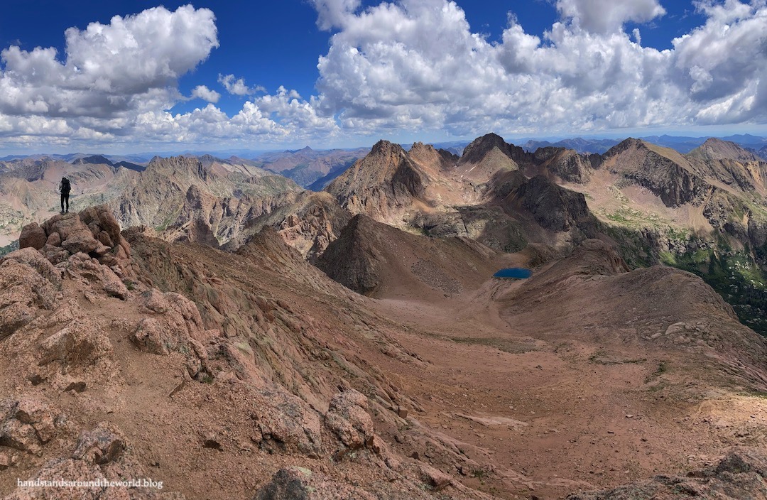
From the saddle, we had an excellent view of the remainder of our route up Eolus. It looked… intimidating. The route description made it sound intimidating as well. In reality, it was a lot of fun! Mount Eolus was my favorite of the four Chicago basin 14ers, and my favorite of all the 14ers I’ve summited so far.

From the saddle, we donned our helmets and then turned left, making our way along the ridge toward Eolus. We scrambled up and over a rocky bump to the beginning of a narrow strip called the catwalk, visible in the photo above. There is a lot of exposure here, but it wasn’t as narrow as it looked and the rock was pretty solid. After the slippery sufferfest of Sunlight and Windom, the solid, grippy rock on these peaks was very welcome.


We carefully made our way across the catwalk to the east face of Mount Eolus. From here, the route alternated between flat class 1 trail and vertical class 3 scrambling to reach the summit. Cairns guided the way, though as we approached the summit there were multiple sets of cairns. I followed one set and K followed another and we both made it up just fine, so clearly it’s a bit of a choose-your-own-adventure situation.
From saddle to summit was 0.3 miles (0.5 km), about 300 feet (91 m) of elevation gain, and took us about 45 minutes.


We hung out on the summit for 25 minutes before retracing our steps down the east face and back across the catwalk to the saddle. From here, it’s a quick scramble to the summit of North Eolus.


Technically – if you want to be picky – North Eolus is not one of Colorado’s 14ers. Although the summit is 14,042 feet (4280 m) above sea level, the prominence from saddle to summit is less than 300 feet (91 m).
Some people in the mountaineering community subscribe to a rule stating that if a high point has less than 300 feet of prominence above a saddle shared with a taller summit, it’s not its own mountain but is instead a sub-peak of the taller summit. According to this rule, then, North Eolus is a sub-peak and not its own mountain.
I personally think that rule is arbitrary, and it seems many Colorado 14er hikers share this sentiment. It only took us 15 minutes of very straightforward scrambling to summit North Eolus from the saddle, so why would you climb all the way up there and not summit it?
Plus, the view from North Eolus was different enough from Mount Eolus that I think it’s worth the climb.


We ended up spending quite a while on the summit of North Eolus. Which, by the way, we had entirely to ourselves. The remote location and the fact that it was the middle of the week meant that not many people were summiting these mountains.


But the weather forecast called for late afternoon thunderstorms and we had at least 2 hours of hiking to reach tree line, so eventually we began our descent. Initially, our plan was to hang out at Twin Lakes for a while, but by the time we arrived the sky was looking pretty stormy and we heard a couple rumbles of thunder, so we continued down.


That, as it turned out, was a good decision. While those particular storm clouds passed us by, the next batch did not. Instead, they pelted us with hail. A lot of hail. We were back at our campsite waiting for our dinners to rehydrate when it began, and though we huddled together under our shelter, the hail was bouncing around so much that we both got wet.


The next batch of storm clouds brought lightning and thunder and rain so, though it was only 6:30pm, we retired to the tent for the evening. It rained on and off into the night, and we woke to a soaking wet… everything.
Except the inside of the tent, thankfully.
Fortunately, we didn’t have to catch the train to Durango until 2:45pm, so we had plenty of time to dry out our gear before packing up and heading back to the trailhead.

We arrived back in Durango at dinnertime, ordered some pizza, and set off in hopes of making it back home that night (though we were prepared to stop and camp if necessary). We took turns driving and spent the last hour loudly singing along to the radio to keep ourselves awake… and we made it. It was past midnight when K dropped me off.
And just like that, our Chicago Basin trip had come to an end. I was sore, covered in scrapes and bruises – most of which I had no idea where they came from – and completely exhausted.
This was by far the most challenging backpacking trip of my life. Over four days, we hiked 27.2 miles (43.8 km) with 10,175 feet (3100 m) of elevation gain. It was exhausting. It was exhilarating. The views were unreal.
As I stood on each summit, I felt like I was on top of the world.
But I also want to acknowledge that there were moments of frustration and self-doubt. There were moments when we weren’t certain we were going to make it to the next summit. These mountains challenged us in ways I wasn’t expecting.
But when one of us was struggling, the other was there with words of support and encouragement. We were in this together, every step of the way.
And together, we did it. We summited all four 14ers. We did exactly what we set out to do. And I’m so freaking proud of us!
The Important Stuff:
- Getting there: Mount Eolus and North Eolus are located above Chicago Basin in the San Juan Mountains of southern Colorado. The easiest way to reach Chicago Basin is via the Durango & Silverton Narrow Gauge Railroad, which will drop you off at Needleton. From here, you can hike into Chicago Basin.
- Fees and passes: The cost for round-trip train fare, baggage transportation, and parking for 4 days (split between the two of us) was $142 per person. No fees, passes, or permits are required for the hike itself, however you should sign the trail register at the Needle Creek Trailhead on your way in.
- Hiking: From Needleton via train, as outlined above, it’s approximately 6 miles (9.6 km) and 2850 vertical feet (870 m) to the beginning of Chicago Basin. If you don’t want to take the train, access is via Purgatory Trailhead, which is a 16 mile (25.7 km) one-way hike with nearly 4000 feet (1220 m) of elevation gain. From Chicago Basin to both summits and back is 7-9 miles (11.3-14.5 km) round trip, depending on exactly where in the basin you are camped, with about 3350 feet (1020 m) of elevation gain.
- Route: a complete and detailed route description can be found here. Before heading off on this hike, download the 14ers.com app and save the text and photos for offline use.
- Where to stay: Chicago Basin is the basecamp for an Eolus/North Eolus summit attempt. Backpackers must obey all signage; camping is not allowed above Chicago Basin (there is a sign that says ‘no camping above this point’), and campfires are not allowed anywhere along Needle Creek Trail or in Chicago Basin. Leave No Trace guidelines specify that, whenever possible, you should camp in an existing spot to minimize impact.
- Other: This is a challenging hike. It took us 9 hours to summit both peaks and return to camp, and we are acclimated, in shape, and experienced hikers. We had to route find, navigate talus and scree, and scramble up class 3 terrain. We also had to keep an eye on the clouds and make decisions about whether it was safe for us to continue. This is not a hike for beginners. These mountains should only be attempted by experienced hikers who have proper navigational skills; are comfortable with scrambling, heights, and exposure; and possess the necessary gear (including a helmet) to safely reach the summit.
Leave a Reply to lexkleinCancel reply