I’ll begin by saying this: there are roughly fifty 14ers in Colorado that are easier to summit than Sunlight Peak. Choosing it as my fourth 14er was maybe a little ambitious.
I did it. But it was substantially harder than anything I’ve hiked or summited before. I definitely don’t recommend these peaks for anyone who lacks prior backpacking, scrambling, and bouldering experience. The fact that I know how to rock climb and am comfortable with scrambling, heights, and exposure is the main reason I was successful.
Anyway.
Sunlight and Windom Peaks rise above Chicago Basin, located deep within the Needle Mountains of southwestern Colorado. To reach Chicago Basin, one can either hike from Purgatory Trailhead (a 16 mile/26 km one-way slog) or take the scenic Durango & Silverton Narrow Gauge Railroad to Needleton and hike in from there, shortening the journey to about 6.5 miles (10.5 km). If you missed my post about our train journey and the hike into Chicago Basin, you can read it here.
Our alarm went off at 5:30am and my friend K and I reluctantly dragged ourselves out of the tent. It was early. Way too early. But we had a long, challenging climb ahead of us and we needed to beat potential afternoon thunderstorms, so an early start was necessary.
(In retrospect, we actually should have started 1-2 hours earlier. We very much underestimated how long this hike would take us and we were fortunate that the weather held out.)


A well-formed trail travels to the back of Chicago Basin, turns to the north, and climbs to Twin Lakes, gaining 1500 feet (455 m) of elevation in approximately 1.5 miles (2.4 km). It’s a very steep climb, and it took us about 1.5 hours to reach the lakes.


And honestly… if climbing 14ers isn’t your thing, this hike is worth it just for Twin Lakes. I would gladly hang out here all day. Many people say Chicago Basin is the most beautiful spot in Colorado, and when we first arrived I was disappointed. The forest has been decimated by pine bark beetles, and I didn’t think the scenery in the basin was any better than elsewhere in the state. But Twin Lakes is amazing!


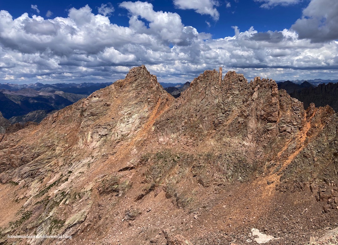
From Twin Lakes, Sunlight and Windom Peaks are now visible to the east. Much of the route is visible now too, and it looks daunting. It is daunting. We were just 0.9 miles (1.4 km) from the summit of Sunlight Peak but we still had 1500 feet (455 m) of elevation to gain.
So up we went.
The trail is not maintained after this point, so we were now relying mostly on cairns to guide us. We’d also prepared by studying the route and downloading the route description and photos so we could refer to them periodically and ensure we were on the right track. Cairns led us up and over a headwall to a small flat area.
The cascade tumbling down here is the last chance to refill water bottles. Beware that in a drier year, there may not be water here at all.

From here, the absolute worst part of the hike lay ahead of us: a 0.5 mile (0.8 km), 800 vertical foot (245 m) climb up to the Sunlight saddle. Not only was it one of the steepest things I’ve ever hiked in my life, but it was mostly dirt and scree. Can you say slippery? It was awful. I felt like I was walking on marbles.


From here, we were just 0.1 miles (0.2 km) and about 250 feet (75 m) from the summit. And this was the fun part… it was time to put our helmets on and do some scrambling!
The official route description for this peak says this final section is class 3. However, these ratings can be highly subjective, and for us shorter people there were definitely some class 4 moves. K, who is a very experienced rock climber, breezed right up them all. It took me a bit to find my way up in a couple spots but I felt like, overall, I did pretty well. It only took us 20 minutes from the saddle to the summit.


The official summit marker sits slightly below the summit block. I have a feeling this was done intentionally to discourage people from climbing the summit block. Getting up might not be so bad (though it is a class 4 move) but getting down involves a leap of faith… and if you overshoot the mark or lose your balance when you land, you’ll tumble about 1000 feet (305 m) down the mountain.
As I had no desire to risk falling to my death, I elected to stop just before the leap of faith. If someone wants to be elitist and tell me this doesn’t count as summiting Sunlight Peak, I’ll just ignore them.
I stood on the summit marker.
I summited.


But as challenging as this had been, we were only about one-third of the way through our day. We still had to summit Windom… and then descend back to our campsite. And it was already 10:15am.
So after about 30 minutes on the summit, it was time to head back down.
We carefully navigated back to the saddle and then begin our descent down the slippery scree/dirt crap. Once again, it was awful. Going down may have even been worse than coming up. Even with my hiking poles, my knees hated every step. Also, I slipped and fell and ended up with a nice bone bruise that made sitting really fun for the next few days.
The official route description says to descend all the way back to 13,000 feet (3960 m) before turning and ascending Windom. After carefully analyzing the terrain, we decided to cut straight across on talus at about 13,300 feet (4055 m) and scramble up the granite slaps to the official route on the west ridge of Windom. This saved us some time and it was nice to not lose and regain quite so much elevation.
We caught up with the west ridge route around 13,900 feet (4235 m) and made our way up to the summit. The official route description classifies Windom as a difficult class 2, but once again we found this to be subjective. For us, some of the moves near the summit were class 3.


We summited around 1:00pm, 2 hours and 15 minutes after leaving Sunlight. We had traveled only 0.6 miles (1 km).


And, as it turned out, we still had almost 3 hours to go to get back to our campsite. Like I said… we’d underestimated how long this would take us.
We followed the west ridge route all the way down Windom, which was almost entirely talus. Hikes like this are equally as exhausting physically as mentally; rather than let my mind wander on the way down, as can happen on easier hikes, I now had to spend the descent focusing on careful foot placement as we navigated the endless boulders.


We were briefly stopped not far above Twin Lakes by a small group of mountain goats who were standing right in the middle of the trail and had no desire to move out of our way. This was the day I learned what noise mountain goats make. I’d always assumed they would sound similar to barnyard goats. They don’t. They sound like a squeaky door hinge.


Eventually, they moved out of the way and we were able to continue to Twin Lakes and, ultimately, back to our campsite for the night.
We were exhausted but exhilarated at having summited both peaks!
Now it was time to soak our legs in the creek, eat some dinner, and sleep so we could do it all over again tomorrow.
TBC…
The Important Stuff:
- Getting there: Sunlight and Windom Peaks are located above Chicago Basin in the San Juan Mountains of southern Colorado. The easiest way to reach Chicago Basin is via the Durango & Silverton Narrow Gauge Railroad, which will drop you off at Needleton. From here, you can hike into Chicago Basin.
- Fees and passes: The cost for round-trip train fare, baggage transportation, and parking for 4 days (split between the two of us) was $142 per person. No fees, passes, or permits are required for the hike itself, however you should sign the trail register at the Needle Creek Trailhead on your way in.
- Hiking: From Needleton via train, as outlined above, it’s approximately 6 miles (9.6 km) and 2850 vertical feet (870 m) to the beginning of Chicago Basin. If you don’t want to take the train, access is via Purgatory Trailhead, which is a 16 mile (25.7 km) one-way hike with nearly 4000 feet (1220 m) of elevation gain. From Chicago Basin to both summits and back is 6-8 miles (9.6-12.9 km) round trip, depending on exactly where in the basin you are camped, with about 3750 feet (1145 m) of elevation gain.
- Route: a complete and detailed route description can be found here. Before heading off on this hike, download the 14ers.com app and save the text and photos for offline use.
- Where to stay: Chicago Basin is the basecamp for a Sunlight/Windom summit attempt. Backpackers must obey all signage; camping is not allowed above Chicago Basin (there is a sign that says ‘no camping above this point’), and campfires are not allowed anywhere along Needle Creek Trail or in Chicago Basin. Leave No Trace guidelines specify that, whenever possible, you should camp in an existing spot to minimize impact.
- Other: This is a beast of a hike. It took us 10 hours to summit both peaks and return to camp, and we are acclimated, in shape, and experienced hikers. We were above tree line for almost all of this time, completely exposed to the weather. We had to route find, cross talus and scree, and scramble up class 3 and 4 terrain. These mountains should only be attempted by experienced hikers who have proper navigational skills; are comfortable with scrambling, heights, and exposure; and possess the necessary gear (including a helmet) to safely reach the summit.
Leave a Reply to rkrontheroadCancel reply