I stood atop Mount Blue Sky once.
Three years back, we drove to the summit with my lowland-dwelling inlaws so they could experience Colorado from an elevation of 14,268 feet (4349 m). There is a paved highway that stops just shy of the top. From there, it’s a relatively short walk to the summit.
I know plenty of people get all up in arms about the fact that you can drive up the mountain, but I appreciate the accessibility of it. Not everyone is able to hike, and this provides a way for them to experience the high elevation environment.
We had a beautiful sunny day, with lots of wildlife (Mount Blue Sky is home to bighorn sheep and mountain goats), very little wind, and excellent visibility. Truly, it was the best summit experience we could have asked for.


Despite this experience, though, I wanted to actually hike to the summit with my own two feet. In August 2022, I finally did.
Due to heavy use and limited parking, you must have a timed entry permit to drive the Mount Blue Sky Highway to the summit. Permits must be purchased in advance; 75% are released 30 days prior while the remaining 25% are released two days in advance. The permits are good for three days, which allowed me some flexibility to plan around the weather.
There are different parking locations on Mount Blue Sky, and you should purchase the permit that aligns with what you want to see. I purchased the all-inclusive permit, as I would be parking at Summit Lake to start my hike but wanted to make other stops as well.
Also: note there is no phone service at the entrance. You must download/screenshot your entry ticket in advance so they can scan it at the gate. If you arrive prior to 8:00am, the entrance station will not be staffed; you must display a printed copy of your 8:00am reservation on your dashboard, along with your America the Beautiful Pass, if applicable.
Anyway. I arrived at the byway entrance around 5:30am and began the harrowing 9 mile (14.5 km) drive to Summit Lake. The road is paved the entire way, although in places the pavement is severely warped. Nonetheless, my sedan made it up with no issue.
That being said, the road is also extremely curvy and narrow, with a complete lack of shoulders and guard rails. It’s just the road… and then the edge of the mountain. The views are spectacular, but if you’re afraid of heights or exposure, this is absolutely not the drive for you.
I’m not afraid of heights or exposure, but when I was driving myself to the trailhead, I was terrified. I hated every second of it.


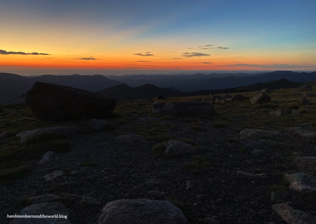
Summit Lake sits at an elevation of about 12,800 ft (3900 m). I arrived at the lake slightly before 6:00am, just in time for a colorful sunrise. The wind was gusty and cold, and I was not looking forward to that aspect of the day. Luckily, it died down as the sun rose. In fact, the rest of the day ended up being unusually calm.


From the trailhead at Summit Lake, I followed the path to the north, around the lake to the Chicago Lakes Trail junction and an overlook of Chicago Lakes. I’ve hiked to these lakes in both summer and winter and they’re lovely.

From this junction, the Mount Blue Sky West Ridge Trail goes left and begins the ascent of Mount Spalding, a 13er adjacent to Blue Sky that I had to summit en route. The sudden steepness of this trail was unpleasant. I prefer hikes that begin gradually, giving me time to ease into it and get my second wind. This was not one of those hikes.

I followed the trail up to the ridge of Mount Spalding. The path was usually visible but when it wasn’t, rock cairns marked the way. This is a class 2 hike, meaning some scrambling is required. For me, as a shorter person, the hardest moves were in this section. In particular, the right photo below was challenging. I know it looks like a jumble of rocks, but it was, in fact, the trail.


Speaking of the trail… it is not always intuitive. Some amount of route-finding is necessary on this hike. Route-finding is a skill that requires practice and preparation. To prepare, I had downloaded the complete route description and photos from the 14ers.com app and saved it for offline use. I’d also spent about 20 minutes studying the route the day before. This, combined with carefully searching for every cairn, kept me on the correct route.


Once reaching the ridge, the trail leads to the summit of Mount Spalding at 13,842 feet (4219 m). From here, the trail descends 250 ft (76 m) to the saddle between Spalding and Blue Sky. After a brief somewhat flat section, I began to regain the elevation I’d lost… and then some. I was still over 1 mile (1.6 km) from the summit of Blue Sky, and yet I had already crested 14,000 feet (4267 m).
The remainder of the trail is an alternating class 1 and 2 route that undulates just below the ridge of Blue Sky. Some of the rocks were wet from the previous night’s rain; it was slow going to ensure I didn’t slip. I was glad to have my hiking poles and I’m not above butt scooting when necessary. I don’t care if I look like an idiot. Safety first.


After nearly two hours of hiking, I reached the summit trail… a series of switchbacks that climbs from the summit parking lot to the actual summit of Mount Blue Sky. Much to my surprise, the trail was empty. So was the summit. There were a couple cars in the parking lot, but none of the people ventured up the trail, so I had the summit of Mount Blue Sky entirely to myself for 15 minutes! I couldn’t believe it!


Unfortunately, the clouds still hung low in the sky. This made me nervous, as I could no longer see any thunderstorms that might be building. The forecast was for storms around noon, and it was only 8:00am. But mountain weather is fickle and lightning is not to be messed with… so after 15 minutes on the summit, I began my descent.
It had taken me two hours to reach the summit and it took only slightly less than that to get back to the car. Class 2 terrain is just not conducive to speedy hiking. By the time I was back to Summit Lake, the sun was peeking through overhead… but the clouds behind me were dark and grey and ugly. I was glad to be off the summit.


My day wasn’t over quite yet, though. About halfway up the Mount Blue Sky Highway is the Mount Goliath Natural Area, home to a grove of bristlecone pines. These resilient trees grow in very harsh environments, yet can live for over 2000 years thanks to special adaptations such as an extremely slow rate of growth and their ability to go dormant for extended periods of time. They’re pretty amazing trees! There’s a small visitor center here, as well as a short trail through the pines. It was a nice leisurely stroll as a cool down after my hike.


And then I had to brave the remainder of the Mount Blue Sky Highway.
I’m glad I summited Blue Sky. I’m now one mountain closer to my goal of summiting all of Colorado’s 14ers.
But I’m never ever driving that road again.
The Important Stuff:
- Getting there: Mount Blue Sky Highway/Scenic Byway (CO Highway 5) begins at Echo Lake Park and climbs 14 miles (22.5 km) to the summit. It’s narrow, curvy, steep, exposed, and probably more terrifying than anything you’ve ever driven. Be sure you are comfortable with these things before committing. There are very few places to turn around.
- Season: the road is closed from approximately October – Memorial Weekend. It may also close for short periods of time during the summer due to poor weather. Always check before setting out.
- Fees and passes: timed-entry reservations are required and must be made in advance. Reservations allow you to enter Mount Blue Sky Highway within a 2-hour window during a 3-day period. Once in, you can stay as long as you want. Cost ranges from $7-$17 depending on which areas you want to access; purchase the permit that matches what you want to do. America the Beautiful passes are accepted, but you still need a timed-entry reservation (you’ll be asked to show both at the entrance station, or you’ll need to print and display both on your dashboard if you arrive prior to 8:00am).
- Hiking: from the summit parking lot, it’s only 1/4 mile (0.4 km) and 134 vertical feet (41 m) to the summit. From Summit Lake, it’s 6 miles (9.6 km) and 2140 vertical feet (652 m) round-trip to reach the summit… relatively “easy” for a 14er, but still a challenging hike that requires some route-finding.
- Route: a complete and detailed route description can be found here. Before heading off on this hike, download the 14ers.com app and save the text and photos for offline use.
- Where to stay: there are many camping options in the surrounding national forest and other lodging options in Idaho Springs, the Front Range, and Echo Lake Park. However, there is nowhere to stay overnight along Mount Blue Sky Highway.
- Food: if you’re looking for a place to stop for pizza and/or beer on the way home, I recommend Beau Jo’s in Idaho Springs.
- Other: although the mountain goats and bighorn sheep here are clearly accustomed to people and hang out near the road and trails, please don’t approach them. They are still wild animals and will defend their territory and their young. We saw a mother mountain goat lunge at someone who got too close.
Leave a Reply to Cheryl, Gulf Coast PoetCancel reply