Handstands Around the World

a former gymnast with a neverending case of wanderlust


Orchards, cliffs, and petroglyphs – Capitol Reef National Park, Utah (part I)

Capitol Reef National Park is the least visited and most underrated of Utah’s “mighty five.” And I sort of understand why. It’s not as archey as Arches or as canyoney as Canyonlands. It doesn’t have Bryce’s hoodoos or Zion’s Angel’s Landing.

But you know what? Capitol Reef is a really cool place that is absolutely worth a visit. You may even stumble upon some arches and canyons while you’re there. We did!

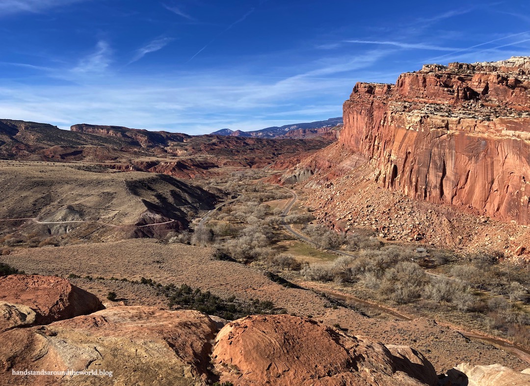
Capitol Reef is the second largest of Utah’s national parks. We spent 2.5 days here and that was enough time for us to hike most of the trails in the central (Fruita) district of the park, but we didn’t even touch the northern (Cathedral Valley) or southern (Waterpocket Fold) districts.

It’s a long skinny park that’s mostly accessible via unpaved and often 4WD-only roads. The northern and southern districts especially are very primitive. One day, I’d like to venture down those back roads and see parts of the park that most people never lay eyes on. But for this trip, we remained in the developed Fruita district.

The town of Fruita was founded in the 1880s by Mormon pioneers who were traveling west in search of religious freedom. Here at the confluence of the Fremont River and Sulphur Creek, they settled at the base of the towering red cliffs of Capitol Reef… so named because, from a distance, this 100-mile (160 km) long wrinkle in the earth’s crust looks like an impenetrable barrier (AKA reef) topped with white sandstone mounds that resemble the dome of the US capitol building.

The reef is visible in very dramatic fashion as you enter the park from the west on Highway 24

Prior to the arrival of the settlers, Capitol Reef was the home of the Hopi, Zuni, and Paiute tribes. Visible evidence of their habitation remains today in the form of petroglyphs that range in age from 700-1700 years old. These petroglyphs can be seen throughout the park, including from a viewpoint right off Highway 24. There are spotting scopes at the viewing platform, but we opted to bring our own binoculars.

The petroglyphs are visible just right of center

From here, there’s also a boardwalk along the river that leads to additional petroglyphs. These petroglyphs are unmarked so you have to search for them as you walk. Unfortunately the sun was casting long shadows on the cliff faces; this made it very difficult for us to spot the petroglyphs. Even so, I enjoyed the short stroll.

Parts of the town of Fruita remain as well and are preserved within the park. This includes the old one-room schoolhouse that was built in 1896 and also served as a church, meeting hall, and gathering place for other social events. Here, we listened to a recording from a former schoolteacher in Fruita. It was very interesting to hear a first-hand account of the difficulties of life in Fruita, as well as the challenges and loneliness that came with being the only teacher in such a remote location. Most didn’t stay long before moving on in search of civilization.

Fruita schoolhouse

We also poked our head into the old blacksmith’s shop. In addition, a barn, a farmhouse, and an old cabin still stand. The barn houses the park horses and the farmhouse has been turned into a small museum and shop.

Blacksmith shop
Behunin cabin

Perhaps the most obvious remnant of Fruita is the orchards. One probably doesn’t usually think of ‘Utah desert’ and ‘orchard’ in the same sentence, but thanks to the mild climate and the river – and an irrigation system the settlers built – trees actually grow quite well here. The settlers planted apple, peach, pear, apricot, plum, cherry, walnut, and almond trees.

Today, the National Park Service still maintains about 2000 of these trees using the same traditional techniques used by the settlers. In the summer you can actually pick the fruit, but since it was November all we could do was walk around while trying not to step in deer poop.

One of Fruita’s orchards
The Fremont River flows along the edge of the orchards

Across the street from the barn and horse pasture is the Cohab Canyon trailhead. The trail climbs steeply up the hillside, providing excellent views of Fruita and the red rock cliffs before turning 90° and entering Cohab Canyon. This relatively shallow canyon is an excellent place for some close-up views of the bizarre geology of Capitol Reef. While the climb up to the canyon is challenging, the walk through the canyon itself is fairly flat.

Looking back at Fruita from the climb to Cohab Canyon

After walking through Cohab Canyon, the landscape opens up and the trail forks, leading to the edge of the cliff and two viewpoints. We opted for the south overlook, and the views were excellent!

Fork in the trail… we headed south (left)
South Overlook
Capitol Reef handstand

We also hiked up to the top of the cliffs north of Fruita on the Navajo Knobs Trail. From the parking area off Highway 24, we climbed first to a natural arch called Hickman Bridge and then continued to Rim Overlook. This was a steep hike, climbing over 1000 vertical feet (305 m) in just over 1 mile (1.6 km). It was worth it, though, for the expansive views.

Hickman Bridge
Navajo Knobs Trail
Parts of the hike crossed expanses of slickrock; the route was marked by cairns
Rim Overlook; Fruita, the orchards, and the visitor center are visible below

I suppose that’s where I’ll leave off for now. More hikes and scenery in Capitol Reef to come next week


The Important Stuff:

  • Getting there: The main entrance to Capitol Reef National Park is in Fruita, located on Highway 24 between the towns of Torrey and Hanksville.

  • Fees and passes: $20/car for a 7-day pass to enter the Fruita district. America the Beautiful passes are accepted. No fee is required to drive Highway 24 across the park.

  • Hiking: There are hundreds of miles of trails in Capitol Reef. We managed to hike most of the trails in the Fruita district and enjoyed each one. Cohab Canyon was probably my favorite. A Fruita hiking guide with trail information can be found here.

  • Where to stay: There is one developed campground in Fruita (reservations are recommended in the summer but not available in the off-season). Hotels and other lodging is available 11 miles (17 km) west in the town of Torrey. We stayed at the Noor Hotel… which was okay but I probably wouldn’t stay there again.

  • Safety: Never ever enter into the canyons or washes in a vehicle or on foot if there is any chance of rain in the vicinity of the park; flash floods are sudden, dangerous, and can be fatal.

  • Other: Capitol Reef is relatively remote and less developed than most national parks. Although amenities are available a few miles away in Torrey, within the park there is no gas or food, only a few bathrooms and water spigots, and limited phone service. Be sure to plan ahead and bring everything you’ll need for the day, including sun and rain gear year round and warm clothes in the off-season.

49 responses to “Orchards, cliffs, and petroglyphs – Capitol Reef National Park, Utah (part I)”

  1. Wow what an incredibly gorgeous park! I love your photographs and the schoolhouse is perfection against that backdrop of cliffs and sky! Would certainly visit here if we ever did a road-trip to that part of the U.S….hopefully one day 🙂

    1. Thank you! This is such an underrated park but so so cool. I hope you make it to Utah one day. It’s a great place to roadtrip!

  2. A fascinating part of the US. A great write up and photos.

    1. Thank you!

  3. These are fantastic photos, Diana! I visited Capitol Reef in 2020 and I completely agree with your sentiments here. It’s a long skinny park, and if you don’t have a 4WD, high-clearance vehicle, you’re not going anywhere! I’ll have to post my Capitol Reef blogs eventually. It’s such a gorgeous park and I can’t wait to go back!

    1. Were you able to visit any of the 4WD areas? I really wish we’d been able to, I’d love to go back and do so.

      1. I was not, unfortunately. It seems like you needed a big Jeep, truck, or SUV to access those areas, so I’ll also have to go back!

  4. Stunning photos! I really want to do more hiking in Utah.

    1. Utah is such a great place, there is endless hiking!

  5. I thoroughly enjoyed this visit to Capitol Reef, Diana. My oh my the land forms and vistas here are incredible! I always enjoy petroglyphs, too, and how fun that there are so many here. Your photos of the landscapes were excellent, really great to see the overviews and terra colors, and always a marvel to see your famous handstand. Much enjoyed, Diana, thank you.

    1. It really is an incredible landscape. Thanks for stopping by!

  6. Nature is beautiful ❤️

  7. Even considering Utah’s many impressive national parks and monuments, it is difficult to rival Capitol Reef National Park’s sense of expansiveness, of broad, sweeping vistas, seemingly endless landscape, or limitless sky and desert rock. Thanks for sharing and have a good day 🙂 Aiva

    1. It really is a vast and expansive landscape. And to think we saw such a small portion of it, and it makes up an even smaller portion of Utah. Despite my many visits to Utah, I still can’t believe how much red rock desert there is.

  8. The landscape and colour of the rocks looks beautiful. I never would have guessed this area could support an orchard.

    1. Right? I was very surprised to find fruit trees the first time I was here.

  9. What absolutely stunning landscape! It really packs a punch.

    1. It really does, it’s so dramatic.

  10. I’ve never even heard of this park, but it looks like it was a good stop for you. The petroglyphs look awesome and the colour of the sky is gorgeous. Maggie

    1. You’re by far not the only one who has never heard of it. Many people here in Colorado haven’t even heard of it, and it’s only 7 hours away. I’m not sure why it gets so overlooked (but I’m not complaining, we loved the lack of crowds).

  11. Capitol Reef is a very underrated National Park. I loved my trip there!

  12. Excellent photos with description! Thanks for sharing 👌❤💕😊

    1. Thank you!

      1. You ate welcome 🎉😊💕stay blessed 😊💕🎉

  13. Spectacular scenery as always in this part of the world, Diana. Looks like the perfect day for a hike. Thanks for sharing. Allan

    1. Thanks Allan. We did have very nice weather here (for November). Lots of sunshine and even a little warmth.

  14. I still can’t believe this landscape. It is just so different than what I picture Utah, but oh so cool! Glad you could make a stop here and I could read about it! Don’t think we’ll be able to fit it in our trip

    1. Yeah, it sounds like you’ve already got a jam packed trip. This park is about 3 hours from Bryce so not exactly a quick stop. I guess that just means you have to come back to Utah again someday 🙂

      1. Yes, I’ll bring Jon next time 🙂

  15. jasonlikestotravel Avatar
    jasonlikestotravel

    It looks like an incredible place to visit. Can’t wait to see some of Utah for myself! 🙂

    1. I have a feeling you’ll enjoy Utah, it’s one giant area of cool landscapes.

  16. Looks like the petroglyphs have changed since were visited. Looks like some fresh fallen stone next to them.

    1. I wondered if there had been petroglyphs on that slab that fell. It’s a bummer that it broke away… but such is the way things work

  17. Indeed – what a lovely view from that classroom! The views are stunning … as are your handstand ☺️. And what a beautiful arch – love all your photo’s!

    1. Thank you!

  18. Oh my goodness, it’s like a really beautiful Mars. Your photos are STUNNING 🙂

    1. Thanks, Han 😊

  19. The photos are lovely. This scenery is beautiful 🤩.

    1. It really is a beautiful place!

  20. Awesome pictures and a very interesting story. Thanks for sharing, in this way we learn about those far off places 🙂

    1. Glad you enjoyed it, thank you!

  21. After visiting both Arches and Zion National Park, we decided on a four-wheel driver Jeep tour of Capitol Reef that left from Moab where we stayed. We never could have made it with our Subaru…

    It was well worth it and one of the features was seeing the canyon where the final scene from Thelma and Louise was supposedly filmed – I believed it!

    1. Oh wow, that sounds like fun! I’d love to drive some of those back roads sometime, but like you, we have a Subaru so we stuck to the maintained areas this time around.

  22. What fabulous scenery!

  23. Good for you to visit the off the beaten path spot. True, it might not be as spectacular, but it’s still amazing scenery and history. Plus, it looks like you had the place to yourself.

    1. We kind of did have it to ourselves, it was much less crowded than the other parks. We always saw at least one other person at each location, but sometimes that was it. It was refreshing after the crowds at Bryce Canyon.

  24. I’ve heard of Capitol Reef, but never went: like you, I’ve also heard that it’s not as well-known or visited as the big ones like Bryce, Zion, or Arches. But I guess given that it’s less-visited, I assume there aren’t many crowds there, which offer you the luxury of enjoying it all the more! Petroglyphs have been a recent interest for me, as I’ve attempted to (but never succeeded) in finding them in the parks I’ve been to so far (Joshua Tree, Zion…). They are beautiful works of art, but very elusive!

    1. Well if you visit Capitol Reef, you’ll definitely find plenty of petroglyphs! We saw them in multiple locations. It was a less crowded park for sure. A couple of the smaller parking areas filled up by mid day but it sure was nice to not have to wake up at the crack of dawn just to find parking.

Leave a Reply to FatmanLittletrailCancel reply