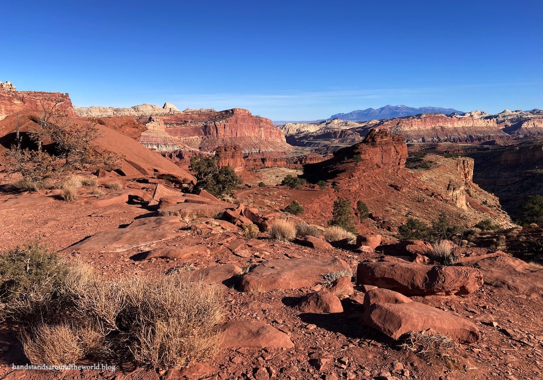
As I mentioned briefly last week, Capitol Reef gets the ‘reef’ part of its name from the fact that, from a distance, the towering line of colorful cliffs appears to be an impenetrable barrier.
This 100-mile (160 km) long wrinkle in the Earth’s crust is called the Waterpocket Fold. Sometime between 50-70 million years ago, tectonic activity led to the formation of an enormous fault. But this was an atypical fault. Usually when a fault forms, the rocks crack and visibly separate.
Not so at Capitol Reef. Far beneath the surface, some of the rocks cracked and separated. The upper layers of rock, however, stayed fully intact and simply bent or ‘folded’ over the fault. Millions of years of erosion has exposed these many folded rock layers and formed the colorful cliffs visible at Capitol Reef today.


Upon closer inspection of the ‘fold’ one will find many small potholes or ‘waterpockets.’ Despite the fact that Capitol Reef only receives about 10 inches (25 cm) of precipitation per year, these potholes retain water and form tiny ecosystems, providing food, water, and shelter to many small animals. Hence the name ‘Waterpocket Fold.’
From the Capitol Gorge Trail, we were able to see some of these waterpockets up close. As it was November, the water in the potholes was frozen.


Capitol Gorge Trailhead is located at the end of Capitol Gorge Road, a 2.5 mile (4 km) maintained dirt road leading into the gorge. From the end of the road, we continued into Capitol Gorge on foot in search of the waterpockets. Along the way we saw petroglyphs, carved into the rock by the Hopi, Zuni, and Paiute people – the original inhabitants of this land.


We also passed the Pioneer Wall, which preserves the more modern carvings made by Mormon pioneers who passed through the Capitol Reef area in the late 1800s-early 1900s. And yes, the Pioneer Wall is essentially just historic graffiti, evidence that people have apparently always had the urge to carve their names into the natural environment as proof of their presence. This was my initial impression.
But as I scanned the names and dates, I realized it’s also a testament to the tenacity and resilience of the pioneers. They traversed this rugged and desolate landscape with little more than horses and wagons, relying on their own skills and ingenuity for survival. It was interesting to put myself in their shoes and imagine what life was like and what challenges they may have faced.


Capitol Gorge marks the southernmost point of our time in Capitol Reef. Beyond this point, high-clearance 4WD and self-sufficiency are required. Back at the trailhead, we returned instead to the Scenic Drive… the only paved road leading into the heart of the park. The road roughly parallels the dramatic cliffs of the Waterpocket Fold.

Next, we turned onto Grand Wash Road which took us into Grand Wash. A wash is a stream channel formed by flash floods. Thunderstorms and heavy rain results in torrents of water rushing downstream, funneled into low spots amongst the landscape. Over time, the sheer volume of water that rushes through can erode quite a deep canyon. Between storms, though, washes are dry. One benefit to visiting in November is that the risk of such storms is almost non-existent so we were able to safely venture into the wash.


After 1.3 miles (2 km), the road turns into a trail and continues through the wash. We hiked about 1 mile (1.6 km) into the wash but opted not to go all the way through.


We also followed a trail up the northern wall of the wash to Cassidy Arch, named for Butch Cassidy who spent some time hiding out in the Capitol Reef area. The trail to Cassidy Arch wasn’t entirely what we expected. We could see the arch from a distance, at which point it became very clear that we weren’t going to be able to reach it without doing some serious rock climbing. As it turned out, the trail actually curved around behind the arch and dumped us out basically on top of it. It was an interesting perspective. If you’re not a big fan of exposure, though, this may not be the trail for you. There are some pretty sheer drop-offs.


Despite the fact that it was late November and the daytime temperature was hovering around 45°F (7°C), we even managed to see some flora and fauna during our time at Capitol Reef. The majority of our animal sightings were deer. The most unexpected plant sightings included a baby yucca and some desert flowers. Capitol Reef is also an excellent spot for stargazing; we returned to Panorama Point late one evening and saw the Milky Way, various constellations, and even a few shooting stars!


Hopefully I’ve convinced you over the last two weeks that Capitol Reef is worth a visit. It’s such an overlooked and underrated destination with a unique history and very bizarre geology. We really enjoyed our time here, always rounding each curve and cresting each high point eager to see what unknown features could be found on the other side. And we came away with a more thorough understanding of the geological processes responsible for the landscapes of southern Utah and a deeper appreciation for the history of this land.
The Important Stuff
- Getting there: The main entrance to Capitol Reef National Park is in Fruita, located on Highway 24 between the towns of Torrey and Hanksville.
- Fees and passes: $20/car for a 7-day pass to enter the Fruita district. America the Beautiful passes are accepted. No fee is required to drive Highway 24 across the park.
- Hiking: There are hundreds of miles of trails in Capitol Reef. We managed to hike most of the trails in the Fruita district and enjoyed each one. I recommend hiking into one of the washes if it’s safe to do so. A Fruita hiking guide with trail information can be found here.
- Where to stay: There is one developed campground in Fruita (reservations are recommended in the summer but not available in the off-season). Hotels and other lodging are available 11 miles (17 km) west in the town of Torrey. We stayed at the Noor Hotel… which was okay but I probably wouldn’t stay there again.
- Safety: As mentioned above, never ever enter into canyons or washes in a vehicle or on foot if there is any chance of rain in the vicinity of the park; flash floods are sudden, dangerous, and can be fatal.
- Other: Capitol Reef is relatively remote and less developed than most national parks. Although amenities are available a few miles away in Torrey, within the park there is no gas or food, only a few bathrooms and water spigots, and limited phone service. Be sure to plan ahead and bring everything you’ll need for the day, including sun and rain gear year round and warm clothes in the off-season.
Leave a Reply