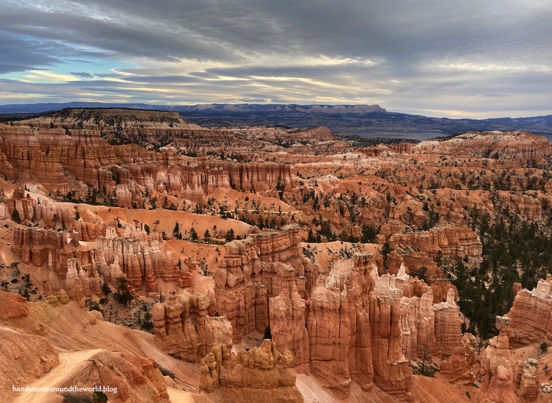
Despite its name, Bryce Canyon is not a canyon. It’s a sequence of amphitheaters located on the edge of the Paunsaugunt Plateau. This name was given to the plateau by the Southern Paiute people, who lived in and around Bryce Canyon for hundreds of years. The word hoodoo is also derived from the Southern Paiute “ooh doo” which roughly translates to “scary.”
There are hoodoos in many areas of the world, and they go by many different names, but the largest concentration of hoodoos in the world is at Bryce Canyon. The Paria River and other runoff from rain and snow begins the process of hoodoo formation as it flows over the edge of the Paunsaugunt Plateau, eroding away softer sediments in some areas and leaving behind parallel rows of rock “fins” in others. These fins are the precursors to hoodoos.
Hoodoos form most readily in areas with many freeze-thaw cycles, of which Bryce has nearly 200 per year due to its high elevation (the top of the plateau sits at 8000-9000 feet (2440-2740 m) above sea level). Water from precipitation events seeps into the rock where it then freezes as the temperature drops. Because water expands when it freezes, it forms what’s called a frost wedge that cracks the rock. Subsequent cycles widen the cracks.
At Bryce, the water also reacts with carbon dioxide trapped in the rocks, forming carbonic acid which accelerates the erosive process. As the cracks widen, hoodoos are formed.

Ultimately a hoodoo will erode away completely. The average lifespan of a hoodoo at Bryce is about 2000 years. However, the Paunsaugunt Plateau formed nearly 15 million years ago, meaning the Bryce Canyon we see today looks very different from the many iterations of Bryce Canyon that have existed over the past millions of years.
The other unique feature of Bryce’s hoodoos is their color. The exposed rocks at Bryce Canyon are part of the Claron Formation, limestone which was deposited about 45-70 million years ago beneath the waters of the large Lake Claron. Over time, the iron and manganese within the rocks became oxidized and impart the red, orange, pink, and purplish colors seen in the rocks of Bryce Canyon. The top layer is made of a harder type of limestone that erodes more slowly and provides a protective “cap” to the hoodoos.
Over the course of our two days in Bryce Canyon, we completed two hikes that dropped down into the main amphitheater and wove through this incredible collection of hoodoos. There’s no disputing the spectacularness (let’s pretend that’s a word) of the views from the top of the plateau, but walking among the hoodoos is a very different way to see the park and I highly recommend taking the time to complete at least one short hike down.
Our first hike was a 3 mile (4.8 km) round-trip journey on the Fairyland Trail from Sunrise Point to Tower Bridge, an arch-hoodoo combination feature that does in fact look like a bridge with tall towers. Along the way, we walked right past many hoodoos of various sizes, shapes, and colors. It was a neat hike!


The second – and much longer – hike was the Figure-8 Loop. This hike starts from either Sunrise or Sunset Points and connects the Navajo/Queens Garden Loop with the Peekaboo Loop, forming a 6.7 mile (10.8 km) hike with 1550 feet (472 m) of elevation gain. We began at Sunset Point and descended on the Two Bridges half of the Navajo Loop, weaving down a steep set of switchbacks lined by towering rock walls.


From here, a short connector trail took us to the Peekaboo Loop, which we followed in the clockwise direction (hiking clockwise is required in the summer and suggested in the off-season). The Peekaboo Loop meanders roughly north-south through adjacent amphitheaters, passing by many unique features and cutting through rows of hoodoos to get from one amphitheater to the next.


Upon completion of the Peekaboo Loop, we took the connector trail back in the other direction and turned onto the Queen’s Garden Trail, which took us to Queen’s Garden and ultimately up to Sunrise Point.


From here, we followed the Rim Trail back to Sunset Point for completion of the hike.


(Note that there are other variations of this hike in the summer, but certain sections of trail are closed in the off-season due to ice and rockfall danger.)
The one downside to hikes like this is that you begin by dropping down and end by forcing your tired legs to climb 600 feet (185 m) back up to the rim of the amphitheater. It wasn’t an easy way to wrap up our time in Bryce Canyon… but it was definitely worth it!
The Important Stuff:
- Getting there: Bryce Canyon is located on Utah Highway 12 in southwestern Utah; any maps app should get you there.
- Fees and passes: there is a $35/car entry fee that’s good for 7 days; America the Beautiful passes are accepted (more info here).
- Hiking: There are dozens of miles of trails within the park, ranging from simple walks along the rim to steep descents into the hoodoos; an overview and list of the hiking trails can be found here.
- Where to stay: In the summer, there are 2 campgrounds and a lodge within the park, in addition to campgrounds, lodges, and hotels immediately outside the park in Bryce Canyon City and a few miles further away in the towns of Tropic and Panguitch. In the off-season, many of these are closed and options are much more limited. We stayed at Ruby’s Inn in Bryce Canyon City (about $90/night in the off-season) and would do so again.
- Other: Given the surrounding desert-like environment, it’s easy to forget that Bryce Canyon is a high elevation park. The canyon rim ranges from 8000-9000 feet (2440-2740 m) above sea level. Summers are hot with intense sunlight and afternoon thunderstorms. Winters are cold and snowy. Come prepared for exposure to the elements, keep an eye on the weather, and remember that the air is thinner up here, making hiking more difficult.
Leave a Reply to ShereeCancel reply