Calling anything “lumpy” is… well, usually not intended as a compliment.
But in this case it’s an apt description of the haphazard rock ridge rising above the northern edge of Estes Park, Colorado. Nestled within a low spot amongst the rocks is Gem Lake, the first hike my fiance and I did when we moved to the state.
But I’d never ventured any further along the trail, so when Chelsea suggested we complete the entire 11 mile (17.7 km) Lumpy Ridge Loop, I was eager to see the rest of what the area had to offer.
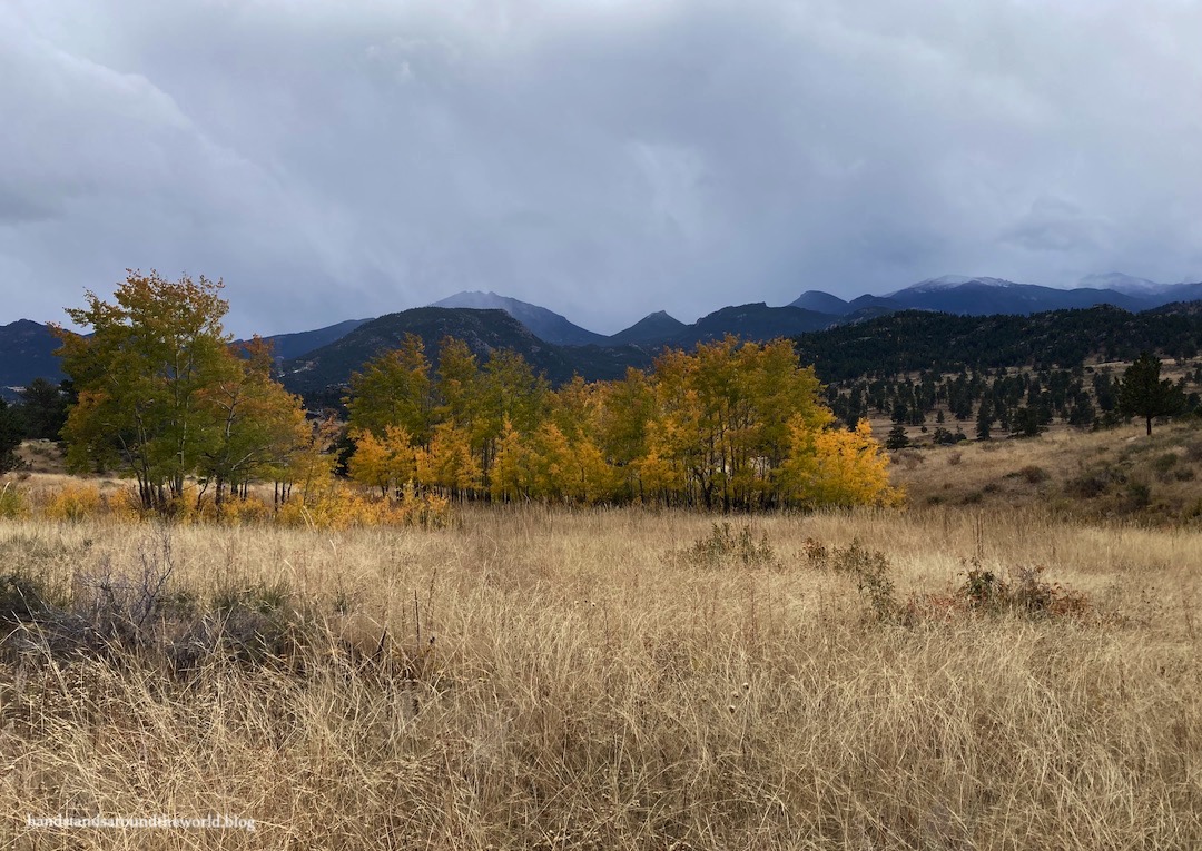
It was closing in on mid-October, so we were rather surprised when we pulled into the parking lot and found it surrounded by bright yellow aspen trees. We’d expected the best of the fall colors to be long gone. But the Lumpy Ridge area was lovely, and it ended up being a very colorful hike.
I may or may not have come home with 150 photos. I’ve narrowed that number down substantially here, although I probably still went a little overboard.
We set off in a counterclockwise direction, which took us up to Gem Lake first. It was funny to look back on how utterly challenging this hike had been for us three years ago. We’d lived in Colorado for only two weeks and were very much not acclimated to the elevation.
This time it was substantially less difficult, and Chelsea and I reached Gem Lake fairly quickly.


After a quick snack we continued past the lake, at which point the trail dropped down the back side of Lumpy Ridge. After a while, we reached the turn off to Balanced Rock, which we bypassed. I’ll have to return and hike that trail another time. For now, we continued downhill toward Cow Creek.

Eventually, we crossed the creek and the forest opened into a meadow. At this point, we reached another fork in the trail; we stayed left on the Lower Cow Creek trail to remain on our loop, and stayed left once more at the next fork onto the Black Canyon-Cow Creek Connector Trail. This was the narrowest and least-trafficked section of trail. While other portions of the loop are used by hikers en route to other destinations, this connector trail is really only used by those completing the Lumpy Ridge Loop.


After a lovely stretch through this open area, we crossed back into the forest and began to climb to the high point on this half of the loop. I never enjoy climbing to a high point that has no views, and that was the case with this one. We were completely surrounded by trees.

After another snack break, now about 2/3 of the way through the loop, we curved around on the Lower Black Canyon Trail and headed in the direction of the trailhead. After a long descent in the forest through Black Canyon, the terrain opened up once again. Simultaneously, we exited the park and entered the MacGregor Ranch.

This historic homestead was established in 1873 by the MacGregor family and remains an operational ranch to this day. Although it is almost entirely surrounded by Rocky Mountain National Park, the ranch is on private land and is not part of the park. The landowners kindly allow access to hikers, as the trail cuts through the edge of the ranch property; please respect the private land by staying on the path and closing the gates behind you.
This walk through the ranch was quite possibly my favorite part of the hike. The mountain views were partially obstructed by the incoming winter weather, but the wide open landscape, fall colors, and varied geology was a very scenic combination.


I kept saying I was done taking photos… and then we’d walk around a curve and be met with more bright colors. I’ve learned that when it comes to colorful leaves, there is no such thing as too many photos.


The fall colors may have been stellar, but the weather throughout our hike was very much not. It was one of those days where conditions were irritatingly variable. We arrived at the trailhead under clearing skies, but we were no more than 5 minutes into our hike when it began raining hard enough that we had to stop and put on our rain gear.
About 30 minutes later, the rain finally stopped and the sun reappeared… at which point we were too warm and had to stop and remove our rain jackets. A while later, the trail began to descend into the shade of the forest (and the clouds returned) and we were once again cold. Back to the sun, and we were too warm. In the latter portion of the hike it snowed on us for about 20 minutes, forcing us to don our waterproof gear once again. Not to mention the fact that we spent most of the hike taking our sunglasses and ear bands on and off every five minutes.
But aside from that, this was a hike we really enjoyed. There are so many absolutely stunning hikes in Rocky that lead to alpine lakes and dramatic mountains. And don’t get me wrong… I’ve done many of those hikes and I love them. But hikes like this tend to get completely overlooked by most visitors. I’m guilty of it too; I often assume hikes that don’t go to lakes or summits won’t be worth the effort.
I’m glad Chelsea suggested this one and I’m glad I gave it a shot, because it was definitely worth it. It was windy and cold and snowing up in the mountains, but down here at Lumpy Ridge we had a lovely autumn Rocky Mountain adventure!
The Important Stuff:
- Getting there: Lumpy Ridge Trailhead is located off Devils Gulch Road in Estes Park; any GPS app should get you there and the parking lot is well-marked. Start early, parking is limited.
- Fees and passes: there is a $30/car daily or $35/car weekly entrance fee to RMNP; America the Beautiful passes are accepted. From May-Oct, if you arrive between 9:00am-2:00pm you will also need a timed entry permit to access this trailhead. Since you do not pass through an entrance station, both items should be displayed on your dashboard.
- Hiking: 11.1 miles (17.9 km) with about 2400 feet (730 m) elevation gain; we followed the loop in a counterclockwise direction and I would recommend this. The first bit to Gem Lake is the busiest part of the trail and it was nice to do this early and beat the crowds. Also, the views along Cow Creek were nicer in this direction.
- Other: be sure to have a trail map with you; there are numerous junctions and although all of them are well-signed, none specifically refer to the “Lumpy Ridge Loop” so you’ll need to know which way to go at each one.
For more park and hiking information, see my post on visiting Rocky Mountain National Park.
Leave a Reply to wetanddustyroadsCancel reply