In general, my day hikes average 8-10 miles (12.8-16 km) in length. Too much more than that and the exhaustion begins to outweigh the enjoyment.
But every once in a while, I stumble across a longer hike that sounds like it’s worth the extra distance. With a name like High Lonesome, I was hopeful this 15.5 mile (24.9 km) loop would be one such hike.
(Spoiler alert: it was!)
On the last Saturday in August, my friend, her husband, and I woke well before dawn and headed to Hessie Trailhead for our hike. This is a ridiculously popular trailhead with very limited parking. They do offer a shuttle from the nearby town of Nederland, which normally I would happily take advantage of in exchange for some extra sleep. But the first one doesn’t leave until 7:00am and that’s too late a start for such a long hike. Plus, the shuttle stops at the main lower trailhead; with their truck, we could reach the upper 4WD trailhead and cut 1 mile (1.6 km) off our roundtrip distance.
Reaching the upper trailhead is in fact a 4WD only kind of adventure. The first half of the road was underwater, the adjacent creek overflowing its banks. Beneath the water was a collection of rocks, a couple of which required some very careful navigation to circumvent (and one of which we weren’t quite successful at circumventing the first time around). Beyond this point, the road was dry but still narrow and rocky.

We were on the trail by about 6:00am, the sky light enough for us to hike without headlamps but the sun still below the horizon. It was definitely feeling like fall in the mountains already, that unmistakable autumn chill in the air.
The trail begins on a bridge across North Fork Middle Boulder Creek and quickly begins to climb up and away from the water. Despite the fact that it wasn’t yet September, a few aspen leaves were beginning to turn. Some of the leaves on the underbrush were already yellow as well. As much as we were looking forward to fall colors, we lamented the end of a summer that felt like it had flown by.

The first 4.5 miles (7.2 km) of this hike were fairly unremarkable, just a steep, rocky trail through the forest. Based on other accounts of this hike we elected to complete the loop counterclockwise, and I would agree that it’s the preferred direction both in terms of steepness and scenery. To go counterclockwise, follow signs at the fork for Devil’s Thumb Lake and Pass.
There are two trail options; Devil’s Thumb or Devil’s Thumb Bypass. I’m honestly not sure what the difference is, as they’re roughly parallel to each other and a similar length. We took the Bypass because we reached it first.


The sun was bright in the sky now and we were beginning to warm up; by the time we reached Jasper Lake, it was feeling a little more like summer again. Jasper Lake, however, was kind of a bummer. It’s a reservoir, a fact I hadn’t realized, and was already being drained. In its half-empty state, it was not nearly as pretty as the photos I’d seen.

Fortunately, the next few miles quickly erased our disappointment. About 1 mile (1.6 km) beyond Jasper Lake is Devil’s Thumb Lake, long and skinny and set at the base of a very jagged mountain with a pinnacle called the Devil’s Thumb. It’s not easy to actually reach the shore of this lake; it’s fairly well surrounded by pine trees and willows. But we could catch a few glimpses as we walked alongside it.


As we began to climb above the lake to Devil’s Thumb Pass on the Continental Divide, the full beauty of the lake came into view. Our ascent was punctuated by frequent stops to catch our breaths… but also to glance over our shoulders at the view. And to watch a couple bull moose hanging out in the willows far below.


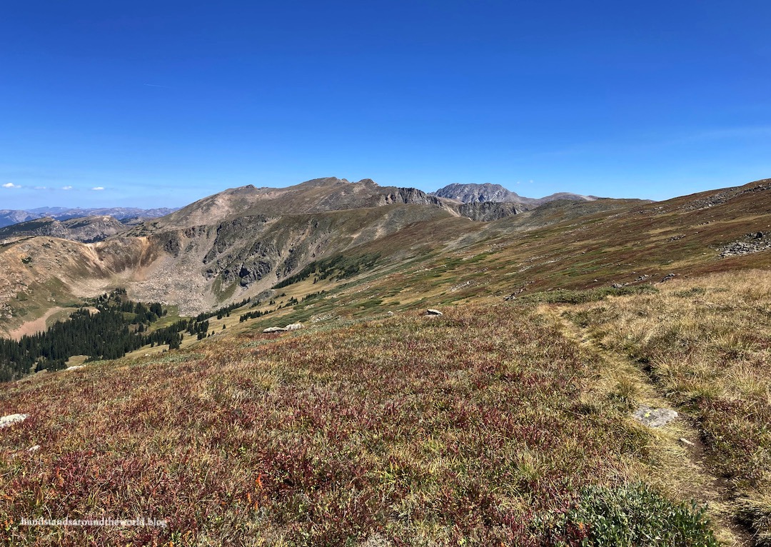
At last we reached the Divide, with a wide expanse of tundra running roughly north-south and views of Winter Park out to the west. It was very clearly autumn in the tundra already as well, the plants turning a lovely shade of red. Hundreds (literally hundreds) of Arctic gentians were blooming, yet another sign that summer was coming to an end.


From Devil’s Thumb Pass, we intersected with the High Lonesome Trail – the section that gives this hike its name. High Lonesome is actually an 18 mile (29 km) stretch of the Continental Divide Trail. This loop includes 3 miles (4.8 km) of the High Lonesome Trail. It’s accurately named; aside from a few trail runners and backpackers, we didn’t see many people up here and I don’t believe we saw any wildlife.
As someone whose soul lives above tree line, this was an absolute highlight of the hike for me as we made our way across the tundra.


After 3 glorious miles, we reached the other highlight of the hike; the intersection with the King Lake Trail and a stunning view of King Lake from above. We decided this made an excellent snack spot and spent quite a while eating and soaking up the sun and enjoying the view.


From here, the High Lonesome Trail continues along the Divide to the south. Our hike, however, followed the King Lake Trail down to the lake.


And from here, it was a looooong 4.5 miles (7.2 km) back to the car.


By the end, we were completely exhausted… 15.5 miles (24.9 km) is a lot of walking for one day. It’s possible – and probably more manageable – to complete this hike as an overnight backpacking trip instead (permits are required). I imagine the climb up and the descent from High Lonesome would be challenging with a backpacking pack, but the distances for each day would be much shorter, and you would have time to take the short side trail from King Lake to Bob and Betty Lakes.
But all in all, it was beautiful as a day hike and, in my opinion, worth the long distance and sore muscles.
The Important Stuff:
- Getting there: This hike departs from the Hessie Trailhead west of Nederland; parking is scarce and they will ticket people parked illegally. To alleviate the parking nightmare, especially if you don’t have a high clearance 4WD vehicle, I recommend taking the free shuttle from Nederland.
- Fees and passes: None for a day hike; permits required for backpacking ($11).
- Hiking: The entire loop is 15.5 miles (24.9 km) from the upper 4WD trailhead, or 16.5 miles (26.6 km) from the main 2WD trailhead; 3200 feet (975 m) elevation gain.
- Where to stay: This can be done as a day hike from much of the northern Front Range. For overnight stays, there are a handful of dispersed campsites along the 4WD road or backpacking is allowed along the trail with a permit.
- Other: If doing this as a day hike, plan for a full day in the mountains. Start early; the middle 5 miles (8 km) of the trail is above tree line and completely exposed. Plan to be down from High Lonesome by noon to avoid afternoon thunderstorms.
Leave a Reply