Most lists of “best hikes near Denver” include St. Mary’s Glacier. And with good reason. For a round-trip total of two hours of driving and 1.8 miles (2.9 km) of hiking, you can see a pretty subalpine lake, bristlecone pines, and stand on a glacier.
Well… sort of.
As it turns out, St. Mary’s Glacier isn’t actually a glacier. It’s a semi-permanent snowfield. Sometimes it never completely melts in the summer. But it isn’t a thick sheet of ice that moves down the mountainside. Thus, it doesn’t meet the geological definition of a glacier.
Regardless, it’s a pretty destination and one that’s fairly accessible. It’s a steep hike, gaining nearly 500 feet (150 m) of elevation in the 0.9 mile (1.5 km) distance, and the starting altitude is over 10,000 feet (3050 m). But even someone not acclimated to the elevation could probably make it if they took it slow.
Parking for St. Mary’s Glacier is in a dirt lot off Fall River Road in Alice, Colorado. It’s $5 cash for the day and the lot fills quickly. We did this hike in April and even in the off-season there were many more people than we expected at 7:30am. Turns out it’s a popular backcountry skiing and mountaineering destination too, in addition to being an access point for other trails into the James Peak Wilderness. Long story short, arrive early.
From the parking lot, you have to walk along the shoulder of the road for a short distance to reach the actual trailhead. While it appears that there’s a shortcut trail, this path goes through someone’s private land – please respect the “no trespassing” signs and use the road.

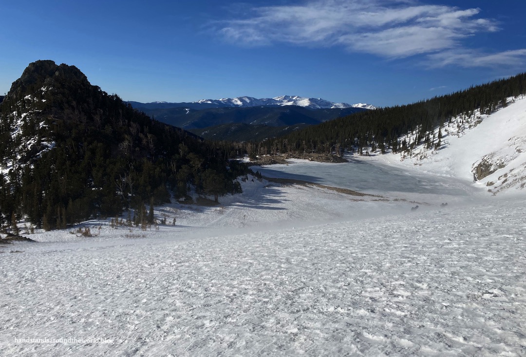
From here, we strapped on our microspikes and began a steady and somewhat icy ascent to St. Mary’s Lake. It was absurdly windy – not unusual for the Colorado mountains – but most of the trail was in the trees. It wasn’t until we reached the lake that we really began to get buffeted around. It’s easy to see why bristlecone pines make up the majority of the forest up here… it’s certainly not the most welcoming environment. But these hearty trees are well equipped for life in such an unforgiving place.


Since the ground was covered in snow, the “glacier” itself wasn’t clearly visible. But using my GPS hiking app, we were able to follow the trail around the lake to stand on the base of the snowfield. We opted not to go any higher due to the wind.


And that’s St. Mary’s Glacier. Since we’d driven this far for such a short hike, we planned to make it worth the trip by doing some more exploring… which I’ll talk all about some other time. There are numerous options in the area. Loch Lomond – a hike we’d done about 6 months earlier – would be a great addition, as it’s fairly short and easy and the trailhead is only about 10 minutes away.

The Important Stuff:
- Getting there: the parking area is off Fall River Road, 9 miles (14.5 km) north of the Fall River exit on I-70; it’s marked with a blue sign and will be obvious due to all the cars
- Fees and passes: $5 cash to park; place cash in the envelope, tear off the flap to stick to your windshield, and deposit the envelope in the slot (located near the porta-potties)
- Hiking: round-trip stats are 1.8 miles (2.9 km) with 480 feet (146 m) of elevation gain; short but steep, with a starting elevation of 10,300 feet (3140 m)
- Where to stay: some of the land surrounding the trail is privately owned and not open to public use; however, backpacking does appear to be allowed on the National Forest land surrounding the lake. This is also easily doable as a day hike from the Denver metro area or any of the towns along I-70 in Clear Creek County
- Other: For summer visits, prepare for crowds and afternoon thunderstorms. In winter, be ready for snow, ice, and wind, and keep in mind that some of the slopes surrounding the lake are prime avalanche terrain
This looks positively gorgeous! One of my favourite things to do is to find snow year round. I would keep this location in my back pocket in case it was late August and I was running out of time to find snow.
I love the high elevations too. Insane how the starting elevation is over 10,000′, when most of the mountains I climb tap out at 8’000 or 10,000′. Good on ya for getting so high 🙂
LikeLiked by 1 person
There is something fun about snow in the summer, isn’t there? We actually just ran into some snow a couple days ago and it was fun to see.
LikeLiked by 1 person
Beautiful as always Diana – really enjoy following along on your walks 🙂
LikeLiked by 1 person
Thank you!
LikeLike
A very steep, short hike, but you get a great view. And you had bluebird skies too 🙂 Maggie
LikeLiked by 1 person
The blue skies here sure are something! I think it’s the altitude that does it… you get above all the smog and other stuff and it’s just blue as can be.
LikeLike
Beautiful views, Diana ☺️ I love seeing mountains covered in snow (sadly don’t get those sorts of scenes often enough in the UK) and have been thoroughly enjoying living vicariously through your photos!
LikeLiked by 1 person
Glad I can share some virtual snow with you 😊
LikeLiked by 1 person
To see ice/snow, even in the warmer months, seems surreal, yet St. Mary’s Glacier looks to defy that idea! The hike sounds a bit too treacherous for me, but it looks to be a very-rewarding one in the end. 🙂
LikeLiked by 1 person
Yeah, if you look hard enough you can find snow in Colorado every month of the year. In fact, it snowed just a little bit on the highest peaks just a couple days ago!
LikeLiked by 1 person
Interesting to read about the definition of a semi-permanent snowfield versus a glacier. I can’t get over your altitudes in Colorado. I just visited Mt. Robson Provincial Park in B.C.–the highest peak in the Canadian Rockies at 12,972 feet (I was looking up at it from around 5000 ft and it looked incredibly high).
LikeLiked by 1 person
Oooh Mount Robson is enormous! But yeah, we really do have a lot of high elevation here. Even Denver is located at about 5400 feet and some of the small towns are closer to 9000.
LikeLike
This looks like such a stunning hike in the spring when much of the landscape is still covered in snow. The wind is always the worst and makes my skin (and lips) feel so dry afterwards. It’s all worth it of course for the views.
LikeLiked by 1 person
Yeah the wind on this day was particularly brutal. It’s probably my least favorite thing about Colorado.
LikeLiked by 1 person
Wow.. what a great hike!! Beautiful views!
LikeLiked by 1 person
Sounds like a hardy adventure, Diana, with microspikes, ice and snow, buffeting wind, and starting at an elevation of 10,000 feet. Unique too. Thanks for sharing this beautiful hike on St. Mary’s Glacier. Congratulations, too, this looks like a tough one.
LikeLiked by 1 person
Thank you!
LikeLiked by 1 person
The starting altitude is at over 10,000 feet? The highest peak in Ireland is just 3,407 feet high so whenever I see mountain peaks measured in well over 5 digits, it makes me realise how much I miss being amongst such impressive peaks. With non-essential travel still forbidden, it doesn’t look like we gonna go on any exciting high altitude hikes overseas this year. So, thanks for sharing and taking me with you 🙂 Aiva xxx
LikeLiked by 1 person
Oh wow, that’s much lower. But considering it’s a fairly small island, I’m also surprised how high the elevation gets. Hopefully things with COVID continue to improve so you’re able to travel again soon 🤞🏻
LikeLiked by 1 person
I chuckled when I saw the STARTING attitude of the hike – “over 10,000 feet…” I guess this demonstrates the difference between the Rockies and the Cascades. The highest point in Oregon is Mt. Hood which is 11,250 feet. No wonder the Portland Trailblazers have trouble playing the Denver Nuggets. We use the excuse of the altitude although maybe it’s just that Denver had a better team this year.
LikeLiked by 1 person
Heh yeah, elevation is a whole different beast here. I think Colorado has the highest average elevation of all the US states. Denver is at about 5400 feet so the baseline here is pretty high.
LikeLiked by 1 person