2020 was a rough year for all of us, Rocky included. First, the park was closed for weeks in the spring due to the pandemic. Then it closed again for 15 days in October and November due to forest fires. In all, nearly 30,000 acres of the park burned. It was absolutely devastating to watch a place I love so much go up in flames.
Parts of the park – the outskirts, away from the fire damage – reopened again on the first Friday of November. So on that very morning, my friend and I found ourselves pulling into one of the newly-reopened trailheads, so excited to be reunited with our park.
Twin Sisters Peak is located on the easternmost edge of Rocky; so close to the boundary, in fact, that the trail actually exits and re-enters the park twice during the 3.7 mile (5.9 km) climb. Although you don’t pass through an entrance gate to hike this trail, an entry fee or pass is still required. Parking is available in a lot near the highway and along the dirt road leading up to the trail. At the end of the road, a path heads back into the forest.
A short distance later, the wide dirt path turns sharply to the right. This is not the trail. The trailhead sign is to the left and the trail heads uphill from there, now a much narrower path through the trees. The forest in this area is predominately tall, skinny lodgepole pines.
About a mile (1.6 km) into the hike, the trail passes through the remnants of a 2013 landslide. It’s a very wide swatch, and you can clearly see where the ground broke free and tumbled down the mountain, taking every single tree with it. Due to the lack of trees, this is where we got our first views of the hike!


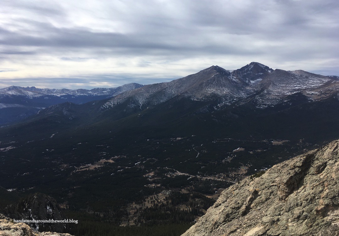
After re-entering the trees we began a series of switchbacks, steadily gaining elevation and bringing us nearly to tree line. The trail then curves around the north slope of the mountain, ascending from the trees and into the increasingly rocky terrain. We now had excellent views of the summit and also the mountains and foothills to the north and east.


Twin Sisters is an 11,400 foot (3475 m) mountain topped with two rocky domes – hence the name. Depending on the angle, both summits might not be visible. From the south, it actually looks like a mountain with a ridge containing multiple rocky high points. But as we curved around the northern slope of the mountain and followed the final few switchbacks up to the saddle, the two summits were very clear.
At last we crested the saddle… and found ourselves staring at a helicopter. There are a few antennas on the summit and we’re assuming the helicopter was transporting a maintenance crew. They were actually just getting ready to leave, so we continued on the trail until we were a safe distance away and then watched the helicopter start its engine and eventually fly away. I’d never seen a helicopter that close before, so it was pretty neat.

Anyway. Once you reach the saddle, the west Twin Sister is to your right and the east is to your left. Most people go up the west one only, as there’s a much more discernible path and it provides the best views of Rocky. However, the east one is very slightly taller and is therefore technically the summit. We went west first.


Now that we were on the summit, we had a clear view into Rocky and were able to discern the burn scar from the fire. On one horrifying evening nearly three weeks prior, the East Troublesome Fire – which was burning many miles west of Rocky – exploded, burning 170,000 acres in 24 hours and sending thousands of people running for their lives in the middle of the night. That night, the fire burned into the park and scorched thousands of acres on the west side.
By the next morning, the flames had jumped the continental divide and begun burning down two drainages on the east side of the park and prompting thousands more people to evacuate their homes. It was this 5000 acre section on the east side of the park that we were now able to see.


A snowstorm a few days later finally brought the fire under control, extinguishing the flames and leaving behind only a few smoldering hot spots and unbelievable destruction. Hundreds of homes and other structures burned, not to mention nearly 200,000 acres of forest. Some irreplaceable historic structures within the park boundaries were also lost.
Even from a distance, we could see the dark outline of scorched earth. We could see how frighteningly close the flames had come to the nearby town of Estes Park. And our hike was punctuated by periodic whiffs of the smell of smoke, no doubt still lingering in the blackened landscape. As excited as we were to be reunited with Rocky, it was heartbreaking to see the aftermath and to know that these areas will never look the same again in my lifetime. I haven’t yet been back to the west side of the park, but that’s where the brunt of the damage occurred and I know I’ll be heartbroken.


After enjoying the familiar view of Rocky’s rugged mountains, we descended the west Twin Sister and began the climb up the east one. There’s not a path and it’s basically a jumble of rocks, so you really have to just pick a route and scramble in an upwards direction. From this peak, we also had a great view out to the east toward the Colorado plains.


I definitely think this is an underrated hike in Rocky. But I also understand why it gets overlooked. The nearby Lily Mountain hike is shorter and easier, but with similar views. I’ve done both and enjoyed both. For someone visiting from a lower elevation, I recommend Lily Mountain. For someone who is acclimated and looking for more of a challenge, Twin Sisters would be the better choice.
Regardless of which hike you choose, I can promise you one thing: Rocky never disappoints!
The Important Stuff:
- Getting there: the parking area is located on CO Highway 7 right across the road from Lily Lake.
- Fees and passes: although there is no entrance station at this parking area, you must still pay the daily ($30/car) or weekly ($35/car) entrance fee or have an America the Beautiful pass in order to hike this trail. From May-Oct, if you arrive after 9:00am you will also need a timed entry permit to access this trailhead. Both items should be displayed on your dashboard.
- Hiking: roundtrip distance is 7.4 miles (11.9 km) with 2400 feet (730 m) of elevation gain.
- Other: we did this hike in November and encountered snow; come prepared in the offseason with microspikes, waterproof shoes, layers, and hiking poles. In the summer, be prepared for sunshine and heat.
For more information, see my posts on visiting Rocky Mountain National Park and winter hiking tips and safety
Leave a Reply to Latitude Adjustment: A Tale of Two WanderersCancel reply