Above tree line is one of my favorite places to be. I love the panoramic views and the tiny plants and the beautiful desolation of the tundra. Tree line here in Colorado is around 11,600-11,800 feet (3535-3600 m); above that elevation, you can generally expect either an endless jumble of rocks or a vast expanse of tundra. As there are thousands of mountains that exceed this elevation, tundra isn’t too difficult to find.
That being said, all trails up to the tundra are not created equally. Depending on the starting elevation, it can sometimes be a real slog. Bison Peak was one such hike. But despite the slog, this was a really cool destination.
Bison Peak is the highest summit in the Tarryall Mountains, rising to an elevation of 12,431 feet (3789 m). It’s named for the American Bison (obviously), as the Lost Creek Wilderness was one of the last refuges for these animals in the late 19th century before they were almost completely eradicated by white hunters.
Two friends and I arrived at Ute Creek Trailhead at about 7:30am on a Saturday in mid-October. Generally it would already be winter in the high country by this point, but 2020 – as one might expect, given the shitshow that it was – brought with it extreme drought. The downside of this was the awful wildfires. I’m sure many of you heard about them in the news (or read about them in my previous posts); hundreds of thousands of acres burned in multiple fires, including the three largest in state history. It was heartbreaking.
The upside, though, is that hiking season in the high country was longer than usual. Hence our ability to complete this hike so late in the year. There was no snow to speak of.
The trail crosses Tarryall Creek on a bridge and parallels the road for a short distance before curving left and following Ute Creek back into the Tarryall Mountains. About 1 mile (1.6 km) in, we entered the Lost Creek Wilderness. This was my first ever hike into this wilderness area – a truly unique part of the state, although that didn’t become obvious until later on. We spent more than half of the hike in the trees, steadily gaining about 3000 feet (915 m) of elevation over 4.5 miles (7.2 km).


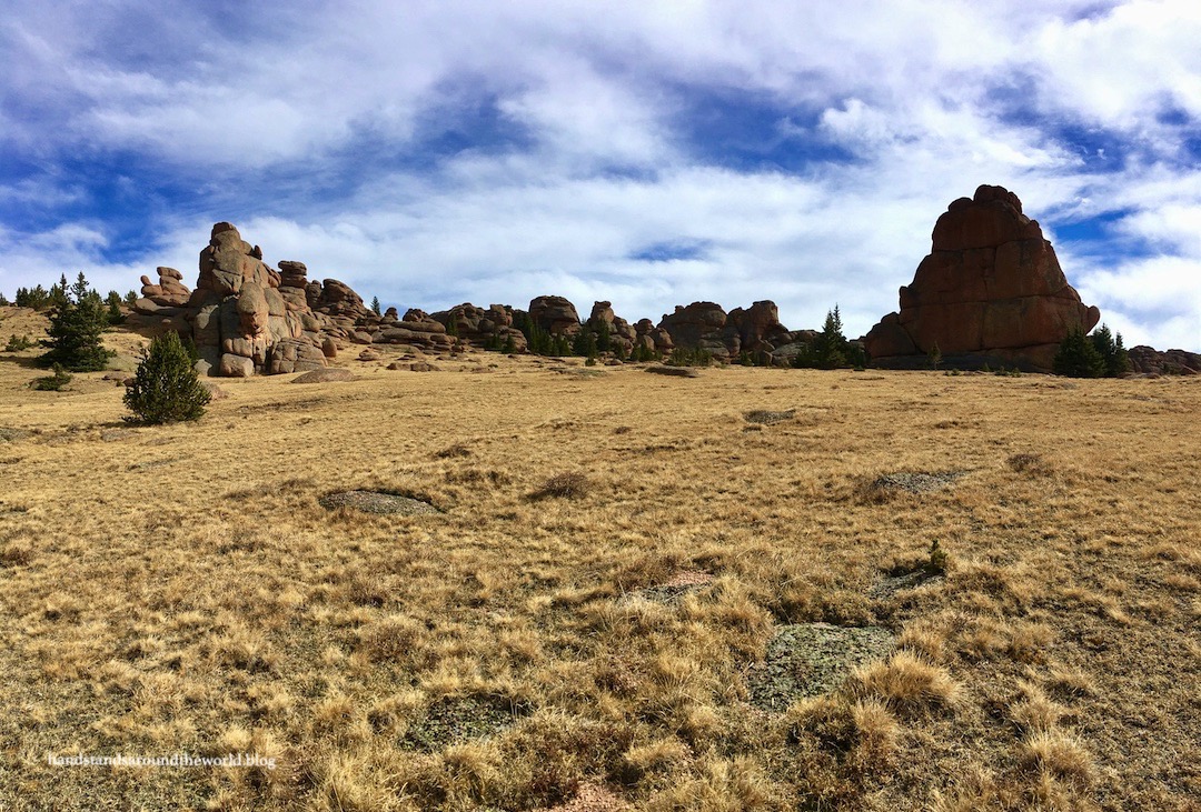
Once clearing the trees, the trail ascends via a couple final switchbacks before coming to an end at the edge of a high plateau. There is a cairn here to guide you back to the trail on the descent. From this point, the official trail ends and you must navigate your way to Bison Peak. There is a vague path, although we weren’t always able to see it. Just head approximately north toward the largest pile of rocks and you will eventually reach the summit. When walking across tundra without a trail, the appropriate thing to do is spread out and forge your own route. This prevents the trampling of tundra plants by multiple sets of feet.


Aside from the wind (so much wind, oh my goodness), I really enjoyed this section of the hike. As expected at this elevation, we could see quite a distance in all directions. But the distant views weren’t the highlight of this hike. The up-close ones were. Bison Peak is topped with dozens of giant, haphazard piles of granite boulders and spires. We spent the remainder of our hike weaving our way around and through these features… and also taking way too many photos of them.


Aside from the final few feet to the summit, no bouldering is required. We mostly followed the vague trail across the tundra and up to the grassy area surrounding the summit rock pile. Here, we dropped our packs in a sheltered spot and climbed up and over a few boulders to the highest point, which is denoted by a couple USGS survey markers, a wooden post, and the remnants of some sort of small structure.


After 5.9 miles (9.5 km) and 3750 feet (1145 m) of elevation gain, we now had to retrace our steps back to the car. This is where the hike really became a slog. Our legs were tired from the ascent and it was a loooong way down through the trees, steadily descending and hard on the knees.
But we did it!
The Important Stuff:
- Getting there: Ute Creek Trailhead is located on Highway 77 (Tarryall Road) southeast of Jefferson, Colorado; it’s marked with a sign and a parking area, and the maps app on your phone should get you there without issue.
- Fees and passes: none.
- Hiking: 11.8 miles (19 km) round trip with 3750 feet (1145 m) of elevation gain.
- Where to stay: this can be done as a day trip from the Front Range, but if you’re looking to spend more time in the area you can camp in the surrounding national forest, backpack this trail (it can also be connected with others to form a loop), or find lodging in the towns of Bailey or Fairplay.
- Other: numerous things about this hike make it more challenging than average, including the relative lack of trail above tree line, the distance and elevation gain, the exposure to the elements, and the lack of places to refill water bottles; definitely plan to be fully self-sufficient for a full day in the wilderness.
Leave a Reply