Do a google search for “best hikes in Colorado” and you’ll inevitably stumble across Ice Lake within the first 5 minutes of your search. And let me tell you, there’s a reason this hike appears on the majority of such lists. It’s unbelievable!
It’s also popular and crowded (let’s be real, most everything in Colorado is these days) but we still really enjoyed it.
The trailhead for Ice Lake is located at the end of South Mineral Road in the San Juan Mountains of southwestern Colorado. The road is gravel but well maintained, and any car should be able to make it.
There are numerous free dispersed camping areas along South Mineral Road, providing many options for those who want to make it an overnight outing. We actually ended up spending the night at one of these, and we really enjoyed it. It was a large area with 10-15 “sites” and a pit toilet. We had our own little spot near the creek, everyone was friendly and quiet, and we watched a nice sunset before settling in for the night.
(Note that there are also a bunch of illegal camping spots that have been used over the years; please obey all guidelines and signage related to parking and camping and only set up in a legal location. Also, please remember to adhere to Leave No Trace principles.)


And then we woke early the next morning and headed up the road to the trailhead, where we cooked some breakfast (priorities… we had to get a parking space first; caffeine and food came second) and then began our hike.
Despite its popularity, this isn’t an easy hike. It’s about 8.5 miles (13.7 km) round-trip and gains 2500 feet (760 m) of elevation. Prior to the hike, when we stood in the parking lot and looked at the terrain, it seemed obvious to me where the trail would be headed. I was wrong. I did not realize we’d be climbing 1300 feet (395 m) up the side of a mountain in the first 2 miles (3.2 km).
The trail begins with a series of switchbacks that cross Clear Creek Falls and then climb alongside it. This section of the trail was heavily damaged by avalanches in early 2019, and the remnants were still very obvious. Walking right through an avalanche path really emphasizes how powerful and destructive snow can be.
(As of October 2020, this area burned in the 600-acre Ice Fire so it probably no longer looks like the photos below.)


The trail then changes direction, weaving through a meadow and into the trees on its way up the mountain side.

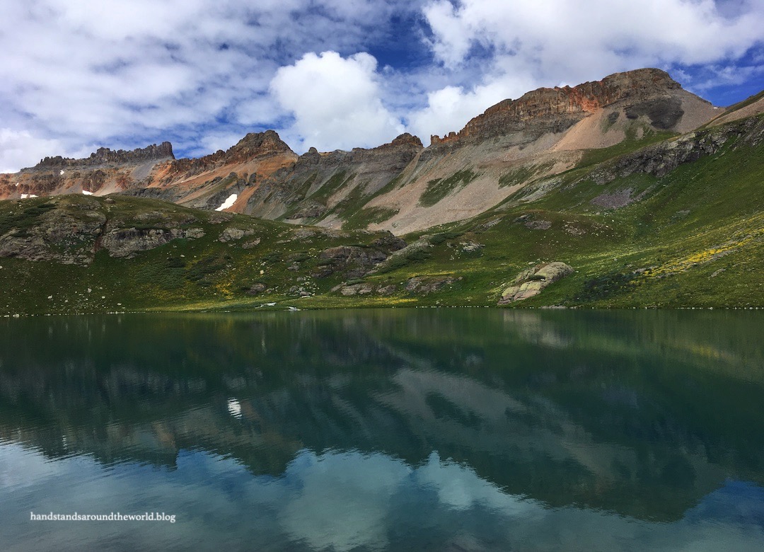
Once you reach the top, the trail flattens and meanders through the Lower Ice Lake Basin. The basin is lush and green, with a creek weaving through the middle and a small lake. The many stands of pine trees provide good shelter for backpackers to pitch their tents.


We were in fact backpacking this trail; however, we opted not to camp in the lower basin. Some people pitch their tents up at Ice Lake itself, but as the lake is above tree line and Colorado is prone to thunderstorms, we didn’t feel that was a safe option. So we split the difference, climbing about halfway up the back wall of the Lower Basin before veering off into a stand of trees that was large enough to provide shelter from a storm.
We ended up having the location entirely to ourselves for the night, probably because it’s not exactly easy to get to. There was a vague path and a visible campsite, so we’re not the only ones to have ventured out and pitched our tent here. But reaching it involved walking through some dense willows, crossing the first small branch of a creek, walking through more willows, crossing the second creek branch, climbing a small but steep hill, walking through more willows, descending said hill, and crossing the final branch of the creek.

After setting up camp, we made our way back through the willows and creek crossings and continued up the trail. Ice Lake was only a short distance above us. As we climbed out of the trees, we found ourselves in wildflower territory. As amazing as the flowers were on our previous hike, these were equally – if not more – incredible. Never in my life have I seen as many wildflowers as I did on this roadtrip.


Add in the colorful mountains and the turquoise water of Ice Lake, and we were surrounded by quite the rainbow of colors. It’s easy to see why this is a bucket list hike.


While Ice Lake is the main destination, there are other lakes up here as well. A trail to the right climbs up to Island Lake. A trail to the left heads up to Fuller Lake. There are also a few tiny lakes up behind Ice Lake. Our plan was to visit all of them.
First stop: Island Lake. Named for obvious reasons.

The hike up to Island Lake was as stunning as the lake itself; the trail led us through fields of wildflowers and ascended to panoramic viewpoints. From one of them, we could even see our tent nestled in the trees far below.


As we made our way back to Ice Lake, we were dividing our attention between the expansive views, the thousands of wildflowers, and the increasingly ominous sky. Grey clouds were rolling in and we were a ways above tree line; not where you want to be in a thunderstorm. By the time we made it back to Ice Lake, it was beginning to rain. However, we hadn’t heard any thunder, so we donned our rain coats and figured we’d crouch behind a boulder and wait it out and then head up to the other lakes.

And this is where it all got away from us.
First, the rain turned to small hail. Not large enough to cause injury, but not pleasant. Then the thunder started. One small rumble far in the distance. That means one thing, and one thing only: get below tree line ASAP. So we began doing just that, figuring we had time to reach safety before the lightning got too close.
We did not.
No more than one minute later, lightning struck so close that the ensuing crack of thunder was immediate. It was terrifying. We took off at a sprint, splashing our way down the trail – which had become somewhat of a muddy creek after 20 minutes of precipitation – as fast as we could.
Even more terrifying was the fact that we were the only ones running for cover. Everyone else seemed unconcerned. A few of them gave us questioning looks as we bounded past. Honestly, I don’t care if they thought we were overreacting. I’ve read enough news stories about people being struck by lightning to know that everyone else was greatly underreacting.
Fortunately, no other lightning bolts struck nearby and we made it back to our campsite safely. We were beyond drenched; wet all the way through to our underwear, pants plastered to our legs, and puddles of water sloshing in our hiking boots. But we were safe.
In the aftermath, we’ve (re)learned two very important lessons.
- #1: as soon as it begins to rain, put on rain coat and rain pants.
- #2: even if there’s no thunder, assume it’s a thunderstorm and start heading down.
Needless to say, we did not explore the remaining lakes. We hoped it might clear up later in the evening – and in retrospect we could have made it up to Fuller Lake, but we were wary of the lingering clouds and didn’t trust that they wouldn’t bring in another storm. So we took a nap and then hung out at our campsite for the remainder of the night, enjoying the view and listening to the many waterfalls cascading down the walls of the basin.


We woke to a colorful sunrise and fog hanging low over the valley.

And that was the final morning of our 5-day San Juans marathon. It didn’t exactly go according to plan. We didn’t summit Sneffels. We got rained on far more than expected. Columbine Lake became a day hike instead of an overnight backpacking trip. We didn’t get to see Fuller Lake. And we hiked back to the car in boots that were still soaked, wet clothes and muddy gear strapped to our packs.
But despite it all, we had an amazing time! The San Juans are our favorite part of the state. Between last summer and this one we’ve only spent about 8 days there, but we already know we’ll never tire of exploring those gorgeous mountains. So as we turned onto the highway and began our journey back north, I knew it wasn’t goodbye forever. It was only goodbye for now.
San Juans, we will be back.
Read more of my Colorado Bucket List series here.
The Important Stuff:
- Getting there: the Ice Lake trailhead is at the end of South Mineral Road in southwestern Colorado, not far from the town of Silverton. Arrive early, parking typically fills by 7:00am.
- Fees and passes: none.
- Hiking: For Ice + Island Lakes, it was about 8.5 miles (13.7 km) round-trip with 2500 feet (760 m) of elevation gain.
- Where to stay: for backpacking, pitch your tent in or near Lower Ice Lake Basin; for camping, find an established dispersed camping spot along South Mineral Road or pay to stay at South Mineral Campground; for lodging, the towns of Silverton and Ouray aren’t too far away.
- Other: thunderstorms are a constant concern during Colorado summers; the best advice is to always plan to be back below tree line before noon… a lesson that was reiterated to us, despite the weather forecast that said the storms wouldn’t show up until 2pm.
Leave a Reply