Summer really got away from me this year.
As I sit down to start writing this post, it’s mid-August and it was only 3 days ago that I finally summited my first 14ers of the summer.
Part of the explanation is that I was originally supposed to climb these peaks in July, but an unexpected summer headcold forced me to reschedule. Life has also just been really busy.
Regardless of the reason, summer flew by way too fast, and by this point my goal of climbing at least eight 14ers this year was feeling more and more unattainable.
If all else fails, at least I’ll be able to say I climbed these two.
(Spoiler alert: all else did, in fact, fail.)
Anyway.
My friend K and I met up the afternoon before our hike and found a nice dispersed campsite just down the road from Missouri Gulch Trailhead. It was a Sunday so there were plenty of open spots, but on a Friday or Saturday I imagine most are full.

We made quick work of setting up camp and having some dinner, and were in bed just after a colorful but slightly hazy sunset. There were a couple large fires burning in western Colorado. Thankfully, the wind was predicted to shift overnight and blow the smoke the opposite direction.

Our alarm went off at 5:00 am, and we both reluctantly dragged ourselves out of our sleeping bags and into the early morning air. It was still mostly dark and the temperature was barely above freezing. Neither of us had slept well. We were not exactly in high spirits.
And it was about to get worse.
It turns out the only thing more miserable than waking up at 5:00 am when it’s cold and dark and you haven’t slept well is waking up at 5:00 am when it’s cold and dark and you haven’t slept well to find that a family of mice decided your car was a good place to spend the night.
Very few things gross me out more than mice, so this was basically my nightmare.
(Believe it or not, this was also not the first time I’ve had mice get into my car. But that’s a story for another time.)
By the light of our headlamps, we surveyed the damage. They’d gotten into my tote bag of food, eaten a hole through the peel of a banana, and chewed their way into my bag of potato chips. They’d also chewed a hole through my backpack and into my trail mix (and transported some of the trail mix into the bag of potato chips…).
Thankfully the rest of my food was untouched and they hadn’t damaged any other items.
They had, however, pooped all over everything. And I mean everything. It was disgusting.
As if that wasn’t bad enough, I opened the hood and there they were, just chilling in my engine compartment. We chased at least 3, possibly 4, of them out.
And despite reorganizing all my gear so everything scented was in a sealed plastic tote and moving my car to a different location, they came back the next night, chewed up a bunch of insulation from inside the dashboard, and used it to make a nest in the glove compartment.
Thankfully they didn’t cause any actual damage to my car, so I guess technically it could have been worse.
But anyway: the hike.
Our planned 6:00am-at-the-latest start was completely derailed by the de-mousification of my car. It was nearly 7:00am when we finally set off; a very late start for a hike up a 14er.
Thankfully, the weather forecast called for only a 7% chance of thunderstorms that afternoon. It’s a good thing, too, because we weren’t even close to making it back down to tree line by noon (which is the typical advice for hiking in the Colorado mountains).


From the trailhead to the summit of Mount Belford is only about 4 miles (6.4 km). However, in that distance the trail climbs roughly 4700 feet (1430 m). It’s steep from the very beginning, and it really just never lets up.
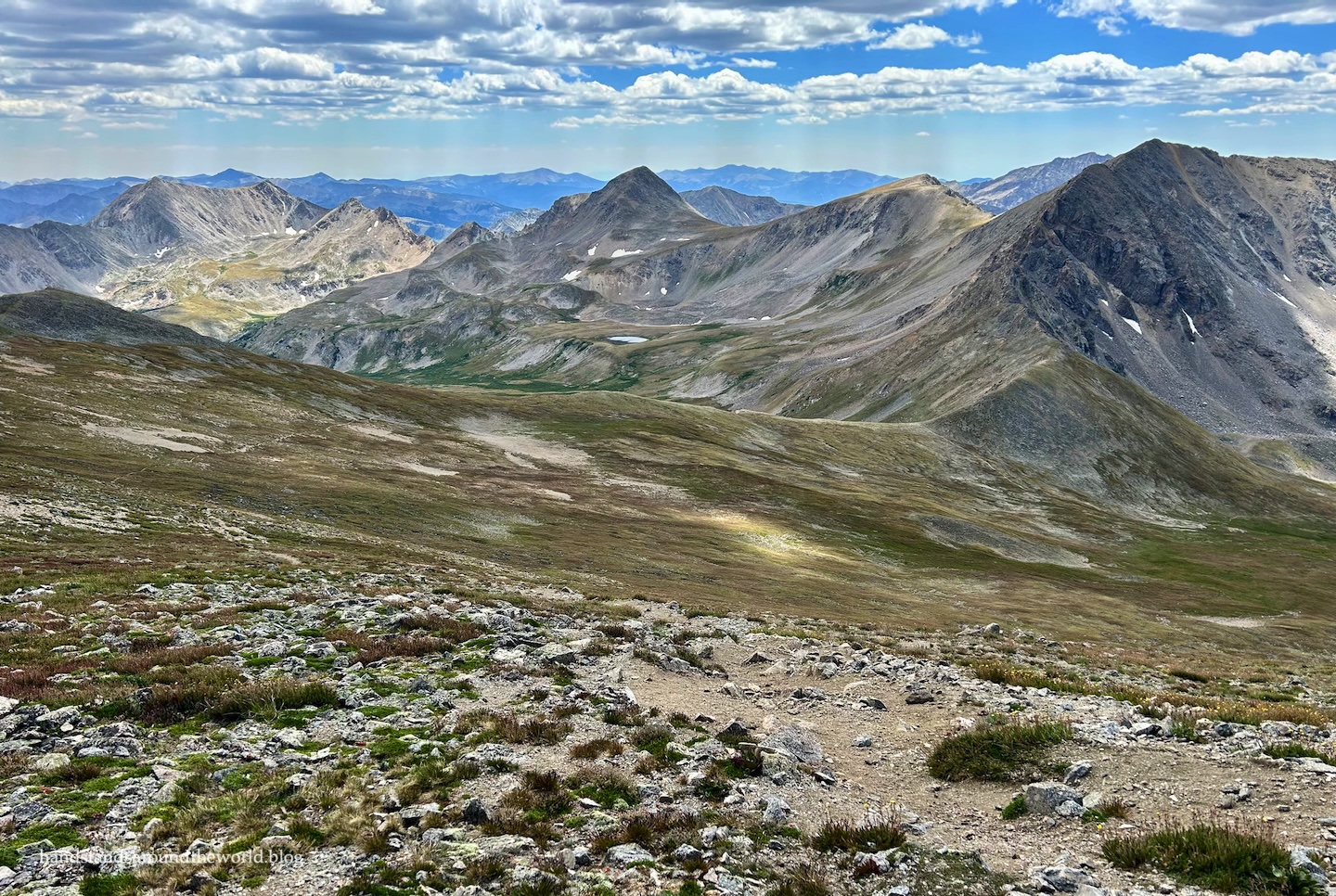
The trail begins in the trees, ascending through a series of switchbacks and opening up into an old avalanche path. From here, we had our first views of the day; back down into the valley behind us and ahead to 14er Missouri Mountain, which is adjacent to Belford and Oxford. We’d originally considered attempting to summit Missouri the next day, but ultimately decided against it. We’ll be back for it one day, though.

The trail then re-enters the forest and continues its relentless climb. We passed the remains of an old cabin just as the landscape began to open up again, giving us our first glimpses of Belford and Oxford looming large above the landscape. We still had a long way to go.

After a short distance, the trail forks; for the most direct route up Belford and Oxford, stay left. For the longer route, stay right. We planned to take the longer route on the descent, but for now we headed left.

The trail heads in a fairly straight line toward the base of the northwest ridge of Mount Belford. From here, there’s really just one word to describe the rest of the hike: up. The trail up the ridge is so steep, gaining 2400 feet (730 m) in just 1.5 miles (2.4 km). It was brutal.


Sometimes, as I’m gasping for breath while clawing my way up a trail like this, I wonder why I do this to myself. Then I pause and look around and I remember why. The higher we climbed, the more we could see. Nothing beats the view from 14,000 feet!


Finally, just over 4 hours after departing the trailhead, we reached the summit of Mount Belford!


We spent about 25 minutes on the summit snapping photos, enjoying the views, and eating a snack. But we hadn’t even reached the halfway point of our hike yet; it was time to tackle Mount Oxford.
The only way to reach Mount Oxford is to descend to the saddle between Belford and Oxford and then regain most of that elevation.

While the ascent of Oxford is fairly gradual, the descent off Belford is brutal. I was clinging to my hiking poles for dear life as I attempted to not slip and slide my way down to the saddle. It’s quite possibly even steeper than the northwest ridge was.
Once the terrain flattened out and we had a chance to look around and enjoy the scenery, we spotted some mountain goats in the valley below!
(I should mention, we’d seen ptarmigans on the way up Belford and would later see two elk off in the distance. I also saw two moose on my drive home… because, well, of course I did.)
About 1.4 miles (2.4 km) and a little over an hour after leaving Belford, we summitted Mount Oxford.


It was already nearly 1:00pm, which meant we couldn’t linger for too long. The weather forecast was proving accurate, so we weren’t worried about lightning. But we still had a long hike back to the car.
And despite having gained 5300 feet (1615 m) of elevation and summitting two 14ers, the uphill portion of the hike was not over. The only way back to the trailhead is to return to the saddle and reascend Belford. Since we planned to take the alternate route down, we didn’t have to go all the way to the summit, but we did have to crest the 14,000 foot mark once more.
We basically climbed three 14ers for the price of two.

After huffing and puffing our way back up Mount Belford (and seeing an ermine dart across the trail in front of us!), this time we turned left, following the Elkhead Pass Trail.
This is the longer (by 1 mile/1.6 km) but less steep route up Belford, and I absolutely don’t regret taking it down. It was so much easier on our knees and, honestly, I don’t think it took any longer. Because it was more gradual, our pace was much quicker.
It was also super pretty, with the wide open views and quite a few late summer wildflowers still dotting the landscape.


Eventually we rejoined the main trail.

From there, it was back into the forest and down the seemingly neverending switchbacks that finally gave way to the trailhead. It was 5:15pm. With just over 10 hours and nearly 13 miles (21 km) of hiking under our belts, we’d made it back to the car.
Though these peaks are not technically difficult – both hikes are class 1 – this was my longest single-day 14er hike so far. I also set a new record for the most elevation gain in one day: 5758 feet (1755 m).
Back at our campsite, we eagerly sank into our big comfy camp chairs and dug into our dinners. We managed to make it until sunset, but we were in the tent immediately after and we both slept much better this time.

The next morning, we packed up camp and headed into town so I could have my car inspected for mouse-related damage before making the drive back home. While the shop checked all the wires and hoses and made sure there were no more mouse nests (or mice) inside my dashboard, we headed back into the mountains to do some paddleboarding.
After a full day of hiking, it was nice to give our legs a break while our arms did most of the work.

We paddled around the lake, over to the opposite shore and back again, and then packed up and headed back into town for some food. By the end of lunch my car was ready to go, so we bade each other goodbye for now (she lives up in the mountains, so we sadly don’t get to see each other that often) and went our separate ways.
Mouse debacle aside, we’d had a wonderful time!


Eighteen 14ers down. Only forty more to go…
Up next: hiking to Colorado’s only true glacier
The Important Stuff:
- Getting there: Missouri Gulch Trailhead is the only starting point for these peaks. The trailhead is located 7.6 miles (12.2 km) up Clear Creek Road (Chaffee County Route 390). The road is dirt but reasonably well-maintained; we easily made the journey in our sedans.
- Fees and passes: none
- Hiking: our roundtrip distance for both peaks – ascending via the northwest ridge and descending Elkhead Pass – was 12.9 miles (20.8 km) with 5758 feet (1755 m) of elevation gain. Elkhead Pass added an extra 1 mile (1.6 km) but the elevation gain is roughly the same for both routes.
- Route: a complete and detailed route description can be found here. Before heading off on this hike, be sure to download the 14ers.com app and save the text and photos for offline use.
- Where to stay: there are a few dispersed campsites along the road, starting around the 5 mile (8 km) mark. Much of the land along the road is private up to this point, so be sure you’re camping on public land. Also, while the road itself is 2WD, access to some of the camping areas requires more clearance than we had. Other options include lodging in Leadville or Buena Vista, the established campground at the beginning of Clear Creek Road, or various public or private campgrounds in the area. Backpacking is also an option, however, we saw very few good places to pitch a tent along the trail.
- Other: one important thing to keep in mind is that the only way to summit Mount Oxford is via Mount Belford (and you have to re-summit Belford on the way down). It can be really easy to get summit fever in a situation like this and push on to Oxford even in poor conditions to avoid having to redo this hike and summit Belford all over again. I completely understand that mindset; I’m glad we were able to hit both peaks because I definitely wouldn’t be excited about redoing this hike. But we knew it was a possibility and constantly monitored the weather just in case. Nearly 9 miles (14.5 km) of this hike is above treeline with absolutely nowhere to hide from a storm.
Leave a Reply to mvbattelleCancel reply