In my opinion, no trip to Yellowstone National Park is complete without a drive over the Beartooth Highway.
This scenic byway – US Highway 212 – connects the northeast (Cooke City) entrance of Yellowstone to the town of Red Lodge, Montana. Between these two destinations lies the Beartooth Mountains, a rugged range that sits atop the Beartooth Plateau. It’s one of those places with expansive views, endless wildflowers, and that fresh high-mountain air that always makes me feel so alive.
I love it!
So when we decided to take my inlaws to Yellowstone and Grand Teton National Parks this past summer, the Beartooth Highway was an obvious addition to the itinerary.
Unfortunately, the weather forecast wasn’t the best; heavy afternoon thunderstorms were predicted. This is not at all unusual weather for this area in the summer months, but it did mean we had to get an early start and we couldn’t linger as long as we would have liked.
Luckily – from a blogging perspective, at least – I’ve driven the Beartooth Highway many times, so I have lots of photos. The images in this post are from a combination of all these trips.
From Cooke City, the highway begins a steady climb through the forest, ascending 2800 feet (850 m) in 12 miles (19 km) as it crosses from Montana into Wyoming. It’s definitely not for the faint of heart, nor those not comfortable driving steep, curvy mountain roads.
(Pro tip: on the way up, if you’re traveling under the speed limit, use one of the many pullouts to allow faster vehicles to pass you. On the way down, shift into a lower gear rather than stepping on the brakes the whole way and overheating them.)

As the road ascends, it passes multiple waterfalls. All are visible from the road, but you can find even better views if you park and walk a short distance.


Right: Beartooth Falls
In addition to the pullouts near the waterfalls, there are many places to pull over and enjoy the views, which steadily improve as the road climbs.


A short detour off the Beartooth Highway leads up to the Clay Butte Fire Lookout Tower. The road is unpaved but well maintained, and any vehicle should be able to make the 3 mile (4.8 km) journey in good weather. Today, the fire tower is a visitor center that is open in July and August.
I know I’ve been to it, but I either didn’t take any photos (less likely) or can’t find them (more likely).

The road continues to climb, eventually leaving the forest behind and crossing into the alpine tundra. This fragile ecosystem experiences long, brutal winters with many feet of snow and short chilly summers. Even in July and August, the temperature is much colder up here. Don’t forget to pack a sweatshirt!
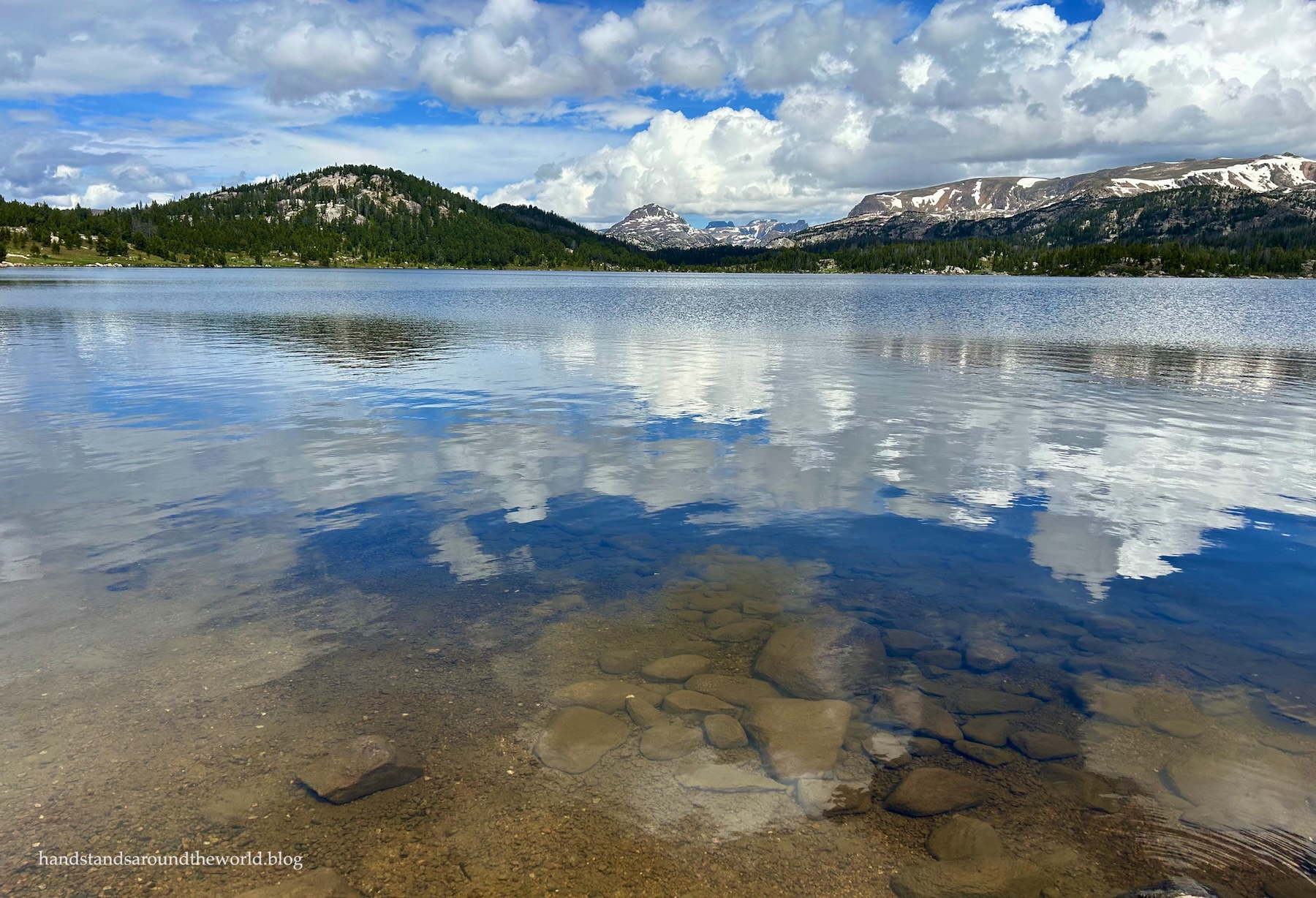
One of my favorite features of the Beartooth Plateau is the hundreds of lakes that dot the landscape. That number is not an exaggeration. Many of these lakes are visible from the road or can be reached on foot with just a short walk. Others are many miles into the backcountry.

The most visited lakes are some of the largest and closest – Beartooth Lake and Island Lake. However, we’ve walked down to some of the smaller ones too, and each lake is pretty in its own way.


Don’t forget to stick your hand in and experience the water of a high elevation lake.
(Spoiler alert: it’s cold!)
(Also, to avoid contaminating these pristine lakes, it’s good practice to clean any lotions, bug sprays, etc. off your skin before touching or entering the water.)


The high point of the highway is Beartooth Pass, elevation 10,947 feet (3337 m). From up here, it kind of feels as though you’re on top of the world. And yet, in every direction, mountain peaks rise even higher, including the canine-shaped peak for which the range is named: the Bear’s Tooth.
(If you zoom in on the 3rd photo below, you might be able to see it.)


There are usually mountain goats near Beartooth Pass. You may need binoculars to spot them in the distance, or you might get lucky and see them close to the road.

Funny story: on a previous trip, we were standing at the edge in the photo above, using binoculars to get a better view of three mountain goats way down by the lakes… and then turned around to realize there were a whole bunch of them standing no more than 50 feet (15 m) from us.

(On the topic of animals: we saw lots of mountain goats on this most recent trip. We also had a mama and baby moose cross the road right in front of us! On previous trips, I’ve seen elk and deer. Grizzly and black bears also live in the Beartooth Mountains, so if you do venture away from your car, you should always travel in groups, make noise, and carry bear spray.)
Due to the altitude and harsh weather, wildflowers don’t reach their peak up here on the plateau until mid-July to mid-August. But when that peak arrives, thousands of flowers color the landscape, including brilliant blue forget-me-nots.
Our most recent trip was just a little too early to see the flowers at their maximum, but there were still quite a few beginning to peek their heads out into these early days of summer.


Descending from the pass to the east, the road loses elevation quickly through a series of switchbacks as it re-enters Montana. At one of these switchbacks is Vista Point, which provides yet another dose of amazing scenery. It’s also one of the few places along the Beartooth Highway that has bathrooms.

This is the last major overlook along the highway. From here, the road continues to descend through the Custer National Forest, eventually reaching the town of Red Lodge.
On a previous trip, we took a detour just shy of Red Lodge and headed up West Fork Road. The next morning, we took a second detour up East Rosebud Canyon. Both are home to campgrounds and day use areas, and would be great places to spend the night for those looking to extend their time in the Beartooth Mountains.
(Notably, I have not been back to these two areas since the severe flooding in 2022. I know they experienced substantial damage, and I’m not sure if all the campgrounds, day use areas, and trails have been fully repaired and reopened.)


On this most recent trip, we did not take any detours owing to the rain that was very quickly catching up to us (as you may have noticed from the Vista Point photo). Instead, we checked into our hotel in Red Lodge and then went out for some beers at Red Lodge Ales.
It was a tasty end to a scenic day.

Next time you’re planning a trip to Yellowstone National Park, or if you’ll be passing through southern Montana on your way to your final destination, I hope you’ll take a few hours to detour up and over the Beartooth Plateau.
It’s among the best that Montana and Wyoming have to offer!
Up next: we’re back in Colorado for a hike full of wildflowers.
The Important Stuff:
- Getting there: This stretch of road is US Highway 212 between Cooke City and Red Lodge, Montana. I’ve driven the road in both directions and can’t recommend one over the other.
- Fees and passes: None. However, if you are planning to drive it from east to west and enter Yellowstone afterwards, you will need to pay the entrance fee when you get to the park ($35/car or America the Beautiful pass).
- Where to stay: There are quite a few Forest Service campgrounds along the highway – most have only pit toilets and potable and cost about $20 per night. Some accept reservations. A couple do not allow tents due to bear activity, so be sure to check the regulations for each location. Here is a list and more information. For hotels or other lodging, the towns on either end of the highway – Cooke City and Red Lodge – are pretty much the only options.
- Hiking: There are 100+ miles (160+ km) of trails on the plateau. I’ve hiked approximately 0 of those miles, so I really can’t say anything specific except that this is grizzly country. Always hike in groups, make noise, and carry bear spray (and know how to use it).
- Other: Be prepared for the effects of altitude – thinner air, cooler temperatures, intense sun, and unpredictable weather. Pack plenty of food, water, sunscreen, and warm clothing. And don’t forget to gas up before you set off… there are no gas stations along this stretch of road.
Leave a Reply to RebeccaCancel reply