Well. It’s been a long time coming, but we’ve finally reached the conclusion of my Glacier National Park series. And boy did we ever save the best for last. I’m so glad we were able to end our trip at Sperry Chalet. It was a wonderful place to stay, and it afforded us the opportunity for this incredible hike.
After breakfast, we – along with quite a few of the chalet guests, actually – grabbed our day packs and set off toward Comeau Pass and Sperry Glacier. The chalet is small, though, and everyone is on their own schedule in the mornings, so we actually only encountered a handful of people throughout the day.
The hike begins by dropping down from Sperry Chalet, losing about 200 feet (60 m) in 0.3 miles (0.5 km) to the Sperry Glacier Trail junction. Here, we turned right and began a steady climb, gaining nearly 1800 feet (550 m) in the next 2.7 miles (4.3 km) up to the pass.
The trail cuts across the western slope of Gunsight Mountain, crossing a talus slope and a waterfall along the way. There’s a short section with some exposure and another creek crossing as the trail travels beneath Comeau Pass. It then curves east and begins to gain elevation in earnest, zigzagging up the side of Edwards Mountain.


It was at this point that we ran into a gentleman who had started from Going-to-the-Sun Road that morning and was planning to summit Edwards Mountain and return to his car by the end of the day. He spoke about it so casually, as though it wasn’t a 20-mile (32 km) hike with over 6000 feet (1800 m) of elevation gain, and he wasn’t 72 years old. He also told us he’s hiked every single trail in the park, though, so I guess for him this was just a typical Saturday adventure. We didn’t see him again after Comeau Pass, but I assume he made it.


Partway up the switchbacks, we were forced to detour off the trail for a few minutes to make way for a mama mountain goat and her two babies, as well as an adolescent mountain goat that was tagging along behind them. Once they passed by, we were back on the trail and continuing to climb.
For me, this hike was hard. Granted, this was our eleventh consecutive day of hiking and we’d already logged 75 miles (121 km). The fact that I’d eaten too heavy a breakfast and come down with a mild cold didn’t help. I was moving more slowly than normal and taking frequent breaks.
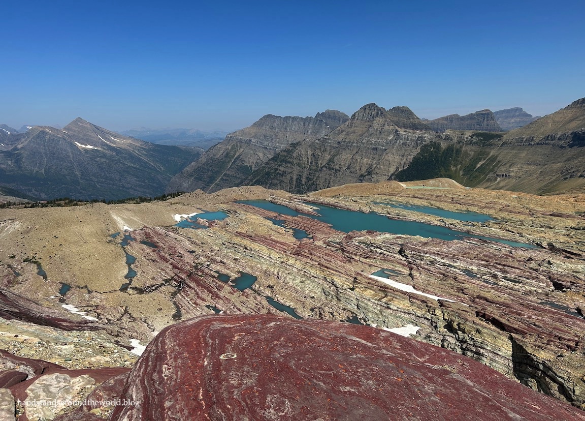
But despite being less than 100%, I still marveled at the colorful layered rocks and wildflowers and alpine lakes alongside the trail, as well as the views that were just getting better and better as we climbed.


At last, we reached the crux of the route: a steep, narrow set of stairs that were blasted into the rock headwall back in the 1920s. It was a bit of a precarious climb, the kind where you have to just stare at the ground to make sure you don’t trip or slip.


I was so fixated on my feet that when I reached the top and lifted my head, I found myself stunned by the beauty of Comeau Pass. The colorful, swirly patterns in the rock were very bizarre, and the view was unbelievable! Mountain goats abound at the pass, and we immediately spotted a few. We dubbed them the ‘Comeau Pass welcoming committee.’


And as beautiful as this was, the best was yet to come.
Sperry Glacier is about 0.5 miles (0.8 km) east of Comeau Pass. It’s not an easy 0.5 miles, though, as five rock outcrops lay between us and the foot of the glacier. Rock cairns marked the way, so off we went, searching for the next cairn and then blazing our own path to it. There’s not a visible trail so some basic route-finding skills are needed. We found ourselves climbing up and over the outcrops, squeezing through a couple narrow gaps in the rock, and even walking across two lingering snowfields. They were relatively flat and the snow was stable, but earlier in the season or in a snowier year, you’d likely want microspikes for this part.


Nearly 50 minutes after reaching Comeau Pass – like I said, it was a slow 0.5 miles due to the terrain – we reached the foot of Sperry Glacier. The glacier is named for Dr. Lyman B. Sperry, a Minnesota professor and physician who is credited with “discovering” it in 1895. It’s one of the largest glaciers in the park, though it has shrunk from over 800 acres back then to less than 300 acres today.
While the rapid shrinkage of Glacier’s glaciers is upsetting, the recession of Sperry Glacier has resulted in exposure of the underlying colorful rock layers, and the low spots in between have become lovely turquoise tarns.


Beyond the tarns, we could see for miles. Though we were surrounded by higher peaks, it felt like we were on top of the world.


The sun was shining and the air was calm and there was no indication of incoming storms so we took our time, spending an hour here eating our lunch and relaxing and basking in the beauty of these upper reaches of Glacier National Park. A couple hikers were headed back down as we arrived, and two more approached not long before we departed, but for the most part we had the place to ourselves. It was amazing, and my husband confidently declared this his favorite hike in Glacier and, in fact, one of his favorite hikes ever!
But what goes up must come down, so eventually we bade goodbye to the tarns and the views and Sperry Glacier and made our way back over the rocks to Comeau Pass. The mountain goats were waiting for us and even followed us to the edge, perching themselves near the top of the stairs and watching us descend.


If you didn’t like going up these stairs, you definitely aren’t going to like coming back down them. Personally, though, I enjoyed the descent thanks to the view.


(Did I take far too many photos of these lakes from every possible angle on both the ascent and descent? Yes, yes I did. I’m not even a little bit sorry.)

And then, since 7.8 miles (12.6 km) and 2000 feet (610 m) of elevation gain wasn’t quite enough for one day, upon return to Sperry Chalet we headed in the opposite direction, catching the Gunsight Pass Trail which heads south from the chalet and climbs to Lincoln Pass, gaining about 500 feet (150 m) in 0.7 miles (1.1 km).


Though it’s not maintained by the park service, a trail branches off here and zigzags up the ridge of Lincoln Peak – which I kept accidentally calling “Lincoln Park” (you know, like Linkin Park, the band) – to its 7450 foot (2270 m) summit. It’s a steep trail, gaining about 300 feet (90 m) in just 0.3 miles (0.5 km), and the surface is mostly slippery dirt and jumbled rocks. Our legs were protesting rather vigorously, and I think my husband was beginning to question my single-minded determination to reach this summit, but I knew it would be worth the effort.


You see, a couple years ago, I saw a photo on social media of two lakes nestled in the mountains with a waterfall tumbling between them. I instantly recognized the scenery as Glacier, but the post wasn’t geotagged, and I couldn’t identify the specific mountains or lakes. I spent a few minutes looking at a park map trying to figure it out but was ultimately unsuccessful.
Nonetheless, I was determined to one day pinpoint the location.
Fast forward to this past January.
We’ve just secured our stay at Sperry Chalet and I’m researching the surrounding hiking trails when I come across the route to Lincoln Pass, with the option to continue to Lincoln Peak. I’m on google maps and I decide to drag and drop the little guy on the various blue dots to check out the terrain and the scenery.
Imagine my surprise when the image from the summit of Lincoln Peak appears and it’s the very view I’ve been searching for!
It was worth every steep, slippery step, as well as all the sore muscles I had the next day. This was an absolutely amazing way to end an incredible twelve days in Glacier!


For the most part, I’m not a person who likes to visit the same place over and over and hike trails I’ve hiked before. Glacier National Park is one of the few exceptions. I love this park more than I can put into words, and I know I’ll never tire of hiking its trails or being humbled and awed by its immense beauty.
So as we departed Sperry Chalet the following morning and began making our way back to Colorado, I waved goodbye to my favorite place knowing that our separation was only temporary.
Glacier, we will be back!
Up next: we’re back to Colorado and it’s backpacking time!
Hike stats:
- Sperry Glacier: starting from Sperry Chalet, round trip distance is 7.8 miles (12.6 km) with 2000 feet (610 m) of elevation gain.
- Lincoln Peak: starting from Sperry Chalet, round trip distance is 2.1 miles (3.4 km) with 835 feet (255 m) of elevation gain
- To hike from Lake McDonald, add 12.6 miles (20.3 km) and 3400 feet (1035 m) of elevation gain (round trip) to these totals
For more information on visiting Glacier National Park and how to access the park and this trail, please see this post.
For details on the hike to Sperry Chalet and our stay, visit my previous post.
For information on Sperry Chalet reservations and an FAQ, visit their website.
Leave a Reply