In 1930, workers in Glacier National Park blasted a 250 foot (76 m) tunnel through the sheer rock of Ptarmigan Wall, forming an easily navigable connection between the Many Glacier and Belly River Valleys. Located at about 7200 feet (2195 m) of elevation, Ptarmigan Tunnel is now a popular day hiking destination, as well as part of various multi-day backpacking routes through these two regions of the park.
The main and shortest route to Ptarmigan Tunnel begins at the Iceberg-Ptarmigan Trailhead in Many Glacier. We had hiked the first half of this trail two days earlier en route to Iceberg Lake. But we didn’t mind hiking it again, as it’s lovely.

Griswold the Grizzly was not present this time, though we were sure to make plenty of noise as we walked through the area. A little while later we encountered a very large pile of black bear scat in the middle of the trail. It hadn’t been there two days ago, so we redoubled our noise-making efforts as we walked. We didn’t see any other signs of a bear, nor did we see a black bear, so clearly it had long since gone on its merry way.
This time, at the trail junction around the 3 mile (4.8 km) mark, we veered right onto the Ptarmigan Trail. This was all new territory for us now. To reach Ptarmigan Tunnel requires about 2500 feet (760 m) of elevation gain. Up to this point, we’d gained only 700 feet (215 m). We had a lot of uphill to go in the remaining 2.7 miles (4.3 km), and indeed, the entire rest of the hike was a steady incline.


After about 2 miles (3.2 km) we reached Ptarmigan Lake, which was the perfect place to stop for a quick snack.


Then we were off again, traversing the shore of the lake and curving around onto the rocky slopes of Ptarmigan Wall. The remaining portion of the hike was a series of three long switchbacks up to the tunnel. We were both feeling tired, and my husband was starting to come down with a cold, so it was pretty slow going here.
We passed the time with rest stops disguised as photo-taking breaks, and then began to debate why in the world they’d felt the need to build a tunnel when you could very clearly walk all the way up and over Ptarmigan Wall.


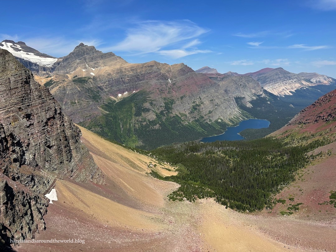
At last, we reached the mouth of Ptarmigan Tunnel. We were excited to walk through, but stopped here first to enjoy the view of Ptarmigan Lake from above and to take photos in the tunnel while no one else was around.


The heavy metal doors are closed each year from approximately October 1 to July 1, so if you want to actually walk through the tunnel there’s a fairly short window of opportunity for this hike. After taking many photos, we began making our way through the tunnel, gravel crunching beneath our feet and the sound echoing off the thick rock walls. At first there was just a bright light in the distance (now this sounds like I was abducted by aliens), but as we got closer, the terrain on the other side slowly came into focus. The video below captures the big reveal.
This is definitely one of the best views in Glacier!

Eventually, we managed to tear our gazes away from the Belly River Valley and Elizabeth Lake and turn our focus to Ptarmigan Wall. It was now towering above us, and as we looked up it immediately became clear why a tunnel was necessary. While you may have been able to walk up to the top from the other side, you would not have been able to descend this side without climbing gear.


We spent a few minutes chatting with some backpackers who were headed back through the tunnel in the opposite direction, nearly done with their trip. They’d just come up the trail you can see in the previous photos, cutting across the mountainside, and mentioned that the view was better from a few yards down. So off we went. I’m glad we heeded their advice because we could now see Swiftcurrent Glacier on the slopes of Mount Merritt. I’m not sure how visible they are in the photo below, but there are waterfalls tumbling down from the edge of the ice.

As you can probably imagine, we were in absolutely no hurry to leave. Once we finally walked back through the tunnel and began our descent, word was spreading about a grizzly near the bottom of the switchbacks. By the time we reached that point, he was way up on the mountainside frolicking in a snowfield. But apparently, hikers initially spotted him swimming in Ptarmigan Lake, after which he crossed the trail and lumbered his way uphill.
I said it in my last post and I’ll say it again: there are a lot of grizzly bears in Many Glacier.

Other than that, it was an uneventful hike back to the trailhead. There were no additional animal sightings, and since this was our fourth pass along the Iceberg-Ptarmigan Trail, there was no need to stop for photos. By early afternoon we were back to the car, and we spent a few minutes cooling off in Swiftcurrent Lake before heading back to our campground for the night.

Up next: a bucket list hike to Grinnell Glacier
Hike stats: 11.4 miles (14.6 km) round trip with 2501 feet (760 m) of elevation gain.
Here is a trail map of the Many Glacier area, including the route to Ptarmigan Tunnel. I also recommend downloading the NPS app and saving Glacier National Park for offline use. You will be able to use the map in the app to track your location.
For more information on visiting Glacier National Park and how to access the Many Glacier area for this hike, please see this post.
Leave a Reply