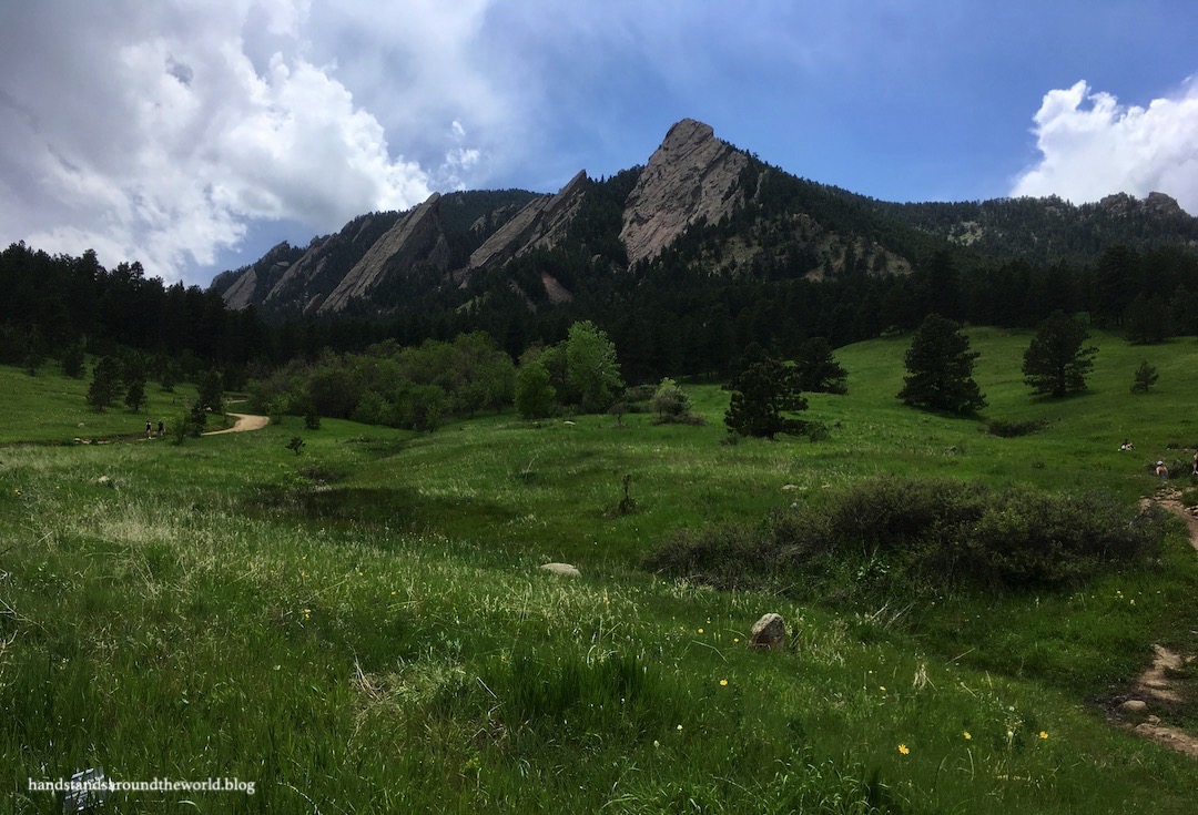
The Flatirons are a prominent facade of five slanted rock slabs that rise above the town of Boulder, Colorado and are probably one of the most recognizable features in the entire region. Their outline and/or name appear all over logos and businesses in Boulder and their sharp profile is visible from many miles away on a clear day.

These slabs are made of red sandstone, part of the same formation that is responsible for Garden of the Gods in Colorado Springs and Red Rocks Amphitheater in Denver. However, the Flatirons also have some conglomerate rock in them, acting as a sort of cement that makes them more erosion-resistant than the other formations.
Chautauqua Park (pronounced shah-TAH-kwah) is located at the base of the Flatirons and is an extremely popular hiking destination due to its proximity to Boulder and ease of access from much of the Front Range. The main parking area and ranger station are located off Baseline Road, but there are multiple other access points from side streets in town and you can also reach Chautauqua via public transit. On nice days – which is most days, in Colorado – parking is a challenge.
Of the many hikes at Chautauqua, there are two that I would say are the most popular: Royal Arch and 1st/2nd Flatiron. These two trails lead up into the Flatirons, while the rest mostly meander through the meadow and forest at the base. Some of these trails connect to the adjacent Boulder Open Space and Mountain Parks (OSMP) public lands, too.

Flatirons Trail
From the Chautauqua parking lot, the Chautauqua Trail begins a gradual but sustained climb for about 0.6 miles (1 km) until it reaches the Bluebell/Baird and Bluebell Mesa trail junction. Bear left on Bluebell/Baird Trail, then turn right onto the 1st/2nd Flatiron Trail and prepare for some elevation gain. This trail climbs 960 feet (290 m) over 1.1 miles (1.8 km) to the saddle between the two flatirons, for some nice views out over Boulder.
I completed this hike in mid-December and it was icy but a friend and I navigated it without issue using our microspikes.


Royal Arch
To reach Royal Arch, you can also take Chautauqua Trail to Bluebell/Baird and continue all the way to the Royal Arch Trail, or you can head south out of the parking area on Bluebell Road which will lead straight to the Royal Arch Trail. I’ve done both and I recommend the latter; it’s shorter and more direct.

Either way, the final 0.8 miles (1.3 km) to Royal Arch involves about 900 feet (275 m) of elevation gain… which includes a steep climb followed by a steep, rocky descent and then a second steep climb.
Once you reach the arch, though, there is plenty of space to hang out beneath it and enjoy the expansive views of Boulder, Denver, and the plains. The sharp angle of the Flatirons is also very apparent from this vantage point.


Despite the relatively short distances, these are challenging hikes because they’re so steep. But Chautauqua is easy to get to, it’s a pretty location, it’s accessible year-round in just about any weather, and there are trails of varying lengths for people of all skill levels. These hikes are also a good way to stay in shape through the winter so that, come summer, you’re ready to get up into the high country.
Truthfully, this isn’t a place I frequent because (a) it’s so crowded, and (b) so many of the people lack any sort of trail etiquette. I’ve been bumped, jostled, and nearly tripped by trail runners who think they have the right-of-way when they don’t. I’ve also been knocked off the trail by someone’s out of control dog.
Trail etiquette guidelines dictate that the person moving uphill has the right-of-way, regardless of how slowly they’re traveling. Unfortunately, a majority of trail runners seem to think they have the right-of-way no matter what.
But when I do brave the crowds and traffic and dogs and runners (aren’t I making this sound so appealing?) and hike here, I get a good workout in and always really enjoy the views. It is definitely worth a visit.
So if you’re ever looking for something to do in Boulder, grab your hiking gear, brace yourself for the chaos, and head on over to Chautauqua for a hike!
The Important Stuff:
- Getting there: Chautauqua Trailhead is on Baseline Road on the western edge of Boulder, but many of these trails can be accessed from other nearby points as well.
- Fees and passes: parking at the main trailhead is free but extremely limited; the surrounding street parking costs a couple dollars, or you can take the free shuttle during the summer.
- Hiking: there are so many trails in this area (see the map here) of all lengths and difficulty levels… there really is something for everyone.
- Where to stay: there are plenty of lodging options in and around Boulder, but no overnight opportunities in Chautauqua park or the surrounding OSMP land.
- Other: I can’t emphasize the popularity of this place enough. There are so many people here no matter the day, time, or weather. And also so many dogs. Boulder has a program for dogs displaying the appropriate tag that allows them to be off-leash but under voice and sight control… although there are always people who don’t follow the rules and let their dogs run wild. If your dog doesn’t do well in this kind of environment, this might not be a good place to bring them.
Leave a Reply to ajeanneinthekitchenCancel reply