There are 58 officially named peaks in Colorado with summit elevations over 14,000 feet (4267 m). We call them 14ers, and summiting all of them is something many people aspire to.
It took me a few years to decide, but it’s a goal I’ve finally committed to. It’s a long-term goal, obviously. There are so many other things I want to see and do, so I won’t be climbing a 14er every weekend. But over the next 10 years or so, I’d like to summit them all.
One thing that’s kind of nice is that some of the 14ers can be summited together. Often, two peaks share a saddle… so once you’ve climbed all the way up there to summit one of them, you might as well cross the saddle and summit the other.
Chicago Basin, deep in the San Juan Mountains of southern Colorado, is home to four such 14ers: Windom Peak, Sunlight Peak, Mount Eolus, and North Eolus. The first two share a saddle and the second two share a saddle, thus it’s common for people to backpack into Chicago Basin and summit two peaks one day and two peaks the next day.
In August, my friend K and I set out to do exactly that.
There are two ways to reach Chicago Basin: (1) on foot from the Purgatory Trailhead, which requires a 16 mile (25.7 km) one-way hike, or (2) via a scenic and historic train ride through the Animas River Canyon, coupled with a 6.5 mile (10.5 km) one-way hike. As we began planning our trip, the choice was obvious.
One phone call later, we had two tickets for the Durango & Silverton Narrow Gauge Railroad and giant grins on our faces.
Fast forward three months, and the grins abruptly vanished when K tested positive for Covid less than one week prior to our departure. Fortunately, the railroad allows free ticket changes with proof of a positive test, so we were able to reschedule our trip.
Nine days later than planned, we were finally heading to Durango. The plan was to car camp somewhere in or near town that night in preparation for our early morning departure. The next morning, we were up early and pulling into the train station parking lot with our backpacks and carry-ons ready to go.

The Durango-Silverton Narrow Gauge Railroad is a 45 mile (72 km) route that travels through the very narrow Animas River Canyon between Durango and Silverton. The track was originally laid by the Denver and Rio Grande Southern Railroad to support local mining operations. It has run continuously since 1882, though it now operates only as a scenic route. In times of low fire danger the train is propelled by a steam engine, but our ride in both directions was powered by a diesel engine.
Although it’s only about 30 miles (48 km) from Durango to the trailhead dropoff point at Needleton, it’s a 2.5 hour journey. The tracks are curvy and it’s uphill the entire way to Silverton, so the train moves slowly. We booked the open-air gondola car, which was only a few dollars more expensive than the enclosed cars and, in my opinion, worth it.
The two main downsides were noise (the train horn and the diesel engine were loud) and smell (exhaust from the diesel engine). Also, bring sun protection and layers; the gondolas have a roof, but the sides are wide open so you are exposed to the weather of the day. It was nice and sunny on the way to the trailhead but we got rained on during the return trip.
(Note that you’ll need to bring a carry-on bag for these items, as well as food, water, and anything else you might want. Your backpacking pack will be transported in the baggage car and you won’t have access to it during the journey.)
The initial portion of the journey parallels Highway 550 heading north out of Durango. It is scenic… but not scenic enough to warrant a spot on my Colorado bucket list.

After about an hour, though, we entered the Animas River Canyon and the journey became immensely more scenic. Because the Animas River Canyon is so narrow, the railroad is the only thoroughfare. There’s not room for a road, as you’ll be able to see in some of the photos below. In some places, there was barely room for the train. The tracks were basically blasted into the edge of the canyon, with sheer rock walls just a few feet away on one side, and a steep drop-off to the river on the other.
It was really beautiful! And also probably nerve-wracking for anyone who is afraid of heights.

We spent most of the 2.5 hour ride standing in front of our seats, oohing and ahhing at the views and taking far too many photos. We did the same thing all over again on the ride back, except that we were seated on the opposite side of the train and got to enjoy the views in the other direction. I came back from this trip with so many photos that I’ll be breaking it up into three separate posts. The next two will be all about our summit attempts of the 14ers. For today, please enjoy these many photos from the train ride.


The train dropped us off at Needleton at 10:45am and by 11:00am we were off, crossing the Animas River on a nice bridge and walking a flat trail roughly parallel to the tracks en route to the actual Needle Creek Trailhead, about 0.5 miles (0.8 km) south of Needleton.
It was a nice easy start to our hike… until about five minutes in, when I ate a fly. Literally. It flew directly into my mouth, bounced off the back of my throat, and I’d swallowed it before I could even attempt to not swallow it. It was very unpleasant.


Once on the Needle Creek Trail, getting to Chicago Basin is a fairly steady uphill trek through the forest. You can usually hear Needle Creek and you can sometimes see it as well. But the best views of this journey are not found here. In place of views, you’ll have flies. Lots and lots and lots of flies. The ones that bite. I don’t know that there is a word to properly convey how annoying and numerous the flies were.
Instead, I’ll say this… pre-treat your clothes with Permethrin (something I wish I’d done) and bathe yourself in DEET (which is basically what I ended up doing).


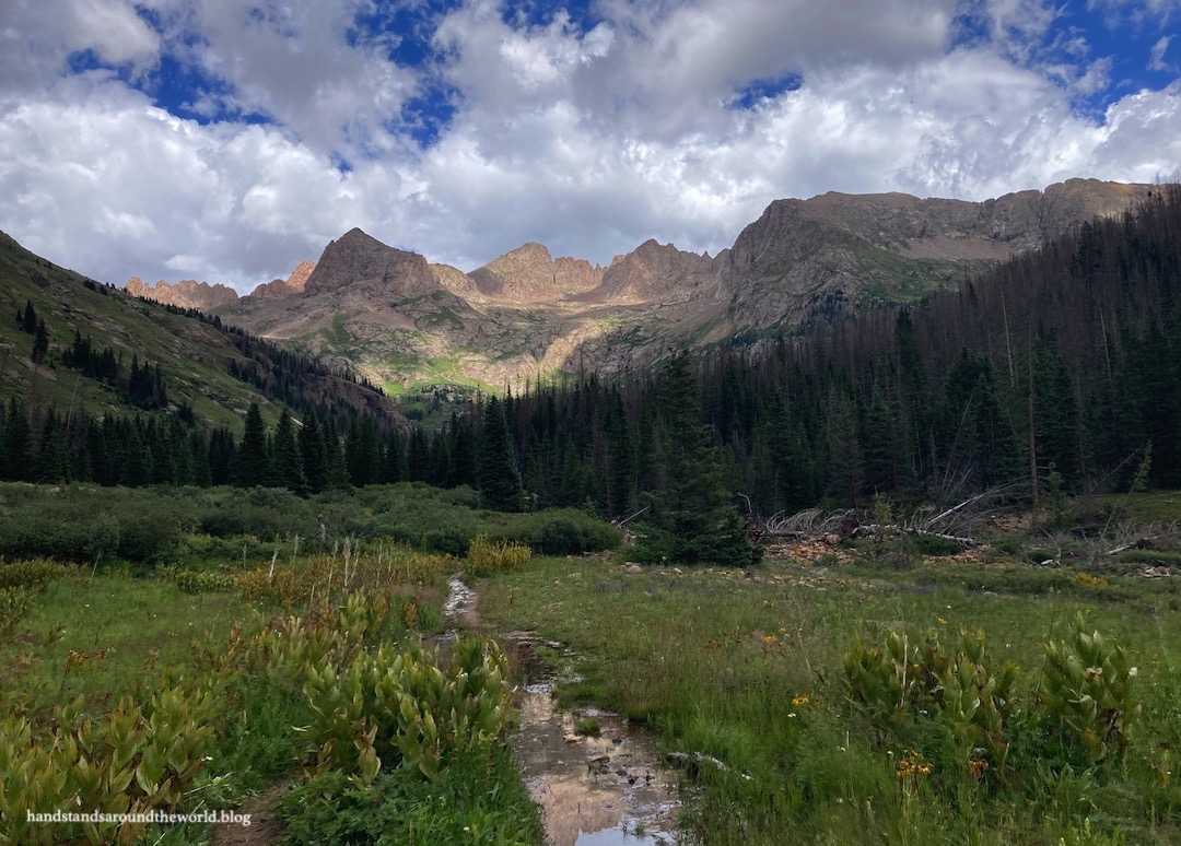
At about mile 6 (9.6 km), we reached the beginning of Chicago Basin. To summit the 14ers, this is base camp; camping is not allowed above the basin. The basin is about 1 mile (1.6 km) long, and there are established campsites all along the way. From our research prior to the trip, we’d decided to find a spot somewhere in the middle. Camping lower would make our hikes up the 14ers even longer. Camping higher would increase our chances of potentially problematic encounters with the resident mountain goats and marmots, which have become way too friendly.


We found a spot at about the 6.5 mile (10.5 km) mark, located just across Needle Creek from the trail, and I think we made a good decision. We had separate locations for our tent, cooking, storing our bear canisters, and using the bathroom. We had a decent view and a nice place to sit near the creek. And we didn’t have any problems with mountain goats or marmots, though there was a deer who visited quite regularly. She wasn’t afraid of us at all, but she left us and our gear alone. We named her Doris.


The remainder of the day was spent setting up our campsite and preparing for the following day. Up next: we attempt the first two Chicago Basin 14ers… Sunlight Peak and Windom Peak.
Read more of my Colorado Bucket List series here.
Leave a Reply to LookoomCancel reply