As you know if you’ve followed me for any length of time, alpine lakes are one of my favorite things. I hike to a lot of them.
So when I say that Chihuahua Lake is one of the prettiest lakes I’ve seen in Colorado, I have a pretty good basis for comparison.
Now that I’ve spoiled the ending of this hike, let’s go back to the beginning.
We arrived at the lower Chihuahua Lake parking area around 7:30am on a Sunday. It’s not marked, but you will find a pullout with room for 4-5 vehicles on the right side of Peru Creek Road. Off to the left is Chihuahua Gulch 4WD Road (FS 263.1). We made it to this point in our Subaru with no issue. You probably could make it in a sedan if the road is dry, but I wouldn’t necessarily recommend it.
Chihuahua Gulch Road, however, is definitely 4WD only. If, like us, you don’t have 4WD, simply walk up the road about 2 miles (3.2 km) to the actual Chihuahua Lake trailhead. It’s not a terrible walk. There’s some shade at the beginning, but eventually the road departs the forest and enters a large meadow framed by 13er Grizzly Peak and 14ers Grays and Torreys Peaks. The peaks provide an imposing backdrop above the expanse of willows and wildflowers.


The meadow is also full of water. We crossed so many creeks on this hike. At one point, the creek was the road. None of the crossings were deep and all were fairly easy to navigate. Hiking poles and waterproof hiking boots were helpful. Later in the season, I imagine there would be less water to contend with.


We made fairly good time through this section, as the road through the meadow is pretty flat. Eventually, we reached the end of the 4WD road and the official start of Chihuahua Lake Trail. The trail begins with a short but steep climb, followed by another flatter stretch.

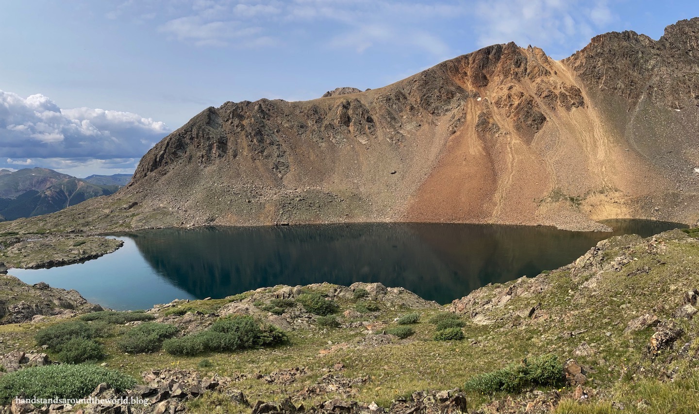
Eventually, the trail reaches the back of the gulch… which is not where the lake is. The lake is up and over the headwall on your left. And, well, there’s no gradual way to get there. You just have to go up and over on a brutally steep, rocky, and somewhat slippery stretch of trail. It was by far the least pleasant part of the hike.


But it was absolutely worth it, because soon we were gazing down at the clear turquoise water of Chihuahua Lake, framed by the colorful slopes of Lenawee Mountain. The lack of wind made for still water and a lovely reflection, and we were nearly alone. We made our way to a rock closer to shore for a snack break while basking in the beautiful solitude.


The trek back to the car was largely uneventful. The initial descent from the lake was the most challenging part, though hiking poles were very helpful. Beyond this point, we made good time. A few drops of rain fell as we neared the trailhead, but the thunder held off until we were back to our car. There were a few more cars parked here now, but overall Chihuahua Lake has managed to remain somewhat of a hidden gem. I hope it stays that way.
That being said, it probably won’t. The population of Colorado is growing, and more and more people are flocking to the outdoors. It’s only a matter of time before this trail gains popularity.
So I will end this post with a gentle reminder that yes, this is public land. Yes, it’s here for all of us to enjoy. But it’s also the responsibility of all of us to minimize our impact and preserve and protect beautiful locations like this for those who come after. So before setting out, I ask you to please take a moment to review Leave No Trace guidelines. Together, we can help maintain the pristine alpine beauty that is Chihuahua Lake.
The Important Stuff:
- Getting there: the lower trailhead is located about 2 miles (3.2 km) up Peru Creek Road at the base of Chihuahua Gulch 4WD Road. We made it here easily in a Subaru. A sedan could probably make it if the road is dry, but it will be slow going. To reach the upper trailhead, at the end of Chihuahua Gulch Road, 4WD and clearance is required.
- Fees and passes: none.
- Hiking: from the lower trailhead, the round trip hike is 7.9 miles (12.7 km) with 1950 feet (595 m) of elevation gain. From the upper trailhead, it is about 3.8 miles (6.1 km) with 1300 feet (395 m) of elevation gain.
- Where to stay: there are some options for dispersed camping along Peru Creek Road and Chihuahua Gulch Road, however there are also many ‘no camping’ signs… please obey these and be sure to camp in a legal location that is an adequate distance (at least 100 feet/30 m) from the creek. Backpacking is allowed… once again, be sure to camp at least 100 feet/30 m from any body of water. Alternately, this is easily done as a day hike from Keystone, Dillon, Breckenridge, or even the Front Range.
- Other: be prepared for so many creek crossings… I recommend waterproof footwear and hiking poles to help navigate these.
Leave a Reply to The Travel ArchitectCancel reply