Getting Covid at the beginning of July was not part of our summer plans. Especially after successfully dodging it for 2.5 years. I think we both (naively) thought we were among the lucky ones who wouldn’t ever get infected.
But it turns out very little can prevent one from getting Covid when a coworker comes to the office while infected… for an entire week. And so the month of July began in a feverish, achy, miserable fashion. And all our hiking plans went right out the window. Along with our fitness.
Towards the end of the month, we were finally recovered enough to get back up into the mountains. I was very excited to be on the trail again and frolic in the beauty of Colorado’s alpine summer. And since we were already visiting Great Sand Dunes, we were well-situated to hike a trail that wouldn’t ordinarily be very accessible to us, given its distance from home.
In retrospect, maybe our first big post-Covid hike shouldn’t have been a 9.9 mile (16 km) round trip trek that gains 3100 feet (945 m) of elevation en route to South Zapata Lake. It certainly wasn’t the best decision I’ve ever made. But we made it to the lake, and it was absolutely gorgeous, so I don’t really regret it.
The hike begins at the Zapata Trailhead, located off CO Highway 17 in the Sangre de Cristo Mountains of south-central Colorado. The road to the trailhead used to be an unpaved bumpy mess, but it was recently chip-sealed and now any car should be able to make it. Even if you don’t want to hike, the drive to the trailhead is worth it for the view of the dunes and the Sangres.

About 0.5 mile (0.8 km) up the trail is Zapata Falls. Because it’s a relatively accessible waterfall, this trailhead is fairly popular. During the middle of the day, parking is a disaster.
Also, Zapata Falls is tucked back in an alcove that creates a bottleneck; when the trail is crowded, you have to stand in line and wait your turn to view the falls. For both of these reasons, I recommend going either early in the morning or late in the afternoon rather than the middle of the day.
Getting to the falls requires walking through the creek, so you’ll need to wear shoes you don’t mind getting wet or bring sandals to change into. I wore my waterproof Keens and they worked great for both the hike and the creek. I don’t recommend flip flops or similar sandals… the trail is very rocky and the creek is slippery. Best to have something with some support and traction.
I also recommend bringing hiking poles; they were helpful in navigating the creek. You may also want to carry a towel. The water was painfully cold; I wouldn’t want to do this hike in cooler weather.
(Apparently, though, it is possible to make it to the falls without getting your feet wet. I’m not sure how, but our nephew pulled it off. After the fact, he told me, “When you said we had to walk up the creek, I thought it was going to be hard to not get my feet wet.” 🤣)


We returned to the trailhead two days later, this time just the two of us, to hike to South Zapata Lake. To reach the lake, you don’t have to walk in the creek. There is an unmarked turnoff on the right, just before the creek, that leads to the lake.
Almost immediately, the trail begins to climb. And climb. And climb some more. If I had to describe this hike in two words, it would be ‘steep’ and ‘rocky.’ I honestly don’t know how people do it without hiking poles. We were slipping and sliding on the descent, even with our poles. And we were huffing and puffing on the way up. Some of the sections are just stupidly steep. I tried to document it, but steepness is difficult to capture in photos.
In a couple places, I was also wishing I’d worn pants rather than shorts; plants were encroaching upon the trail and my legs got a little scratched up. A few fallen trees also blocked the path. This is clearly a lesser-used and maintained route… which was also evidenced by the fact that it was a Saturday in July and we only saw 11 people between Zapata Falls and South Zapata Lake.


About 1 mile (1.6 km) up the trail is an old miners cabin.

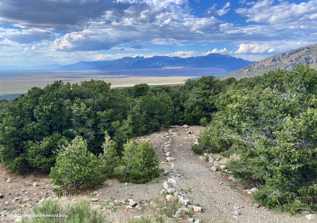
In some locations, we also had a view of where we were headed… way back into the mountains. And behind us, we could see out into the expansive San Luis Valley.


After about 4.5 miles (7.2 km) of climbing, we finally reached tree line. From here, it was about another 0.5 mile (0.8 km) through a lovely alpine meadow to the lake. In our exhaustion, this part seemed to take forever. But eventually, we crested a hill and there was the lake… oddly shaped and bright turquoise, nestled at the base of 14er Ellingwood Point.


We climbed to the high point on the left and enjoyed a lovely picnic break above the lake. If not for the many flies, we may have even stayed here a little longer.


The trail crosses the creek three times en route to the lake. At two of these crossings, you descend to the creek and then climb steeply up the other side. On the way back, we had to do this in reverse. It’s never fun to gain elevation on the hike out, especially when we were already tired from the ascent. Not for the first time, we found ourselves regretting our choice of trail. And by “we,” I mean I was regretting selecting this trail and my husband was regretting not talking me into doing something a little less strenuous.
Fortunately, we’d talked ourselves out of backpacking it, deciding that would be too ambitious two weeks post-Covid. It definitely would have been.
Long story short, if you’re looking for a beautiful lake in the Sangre de Cristos, with a trailhead that can be reached without 4WD and a hike that will absolutely kick your butt… this is the one!
Leave a Reply to travelling_hanCancel reply