Colorado has turned me into a winter person.
I swore that would never happen, but it appears I was wrong.
As a kid, I never liked winter. It’s cold and dark and lasts way too long.
Then I moved out east and my first winter there was marked by 3 giant snowstorms that collectively dropped more than 6 feet (2 m) of snow over the course of about 5 weeks.
After the novelty of my first ever snow days wore off, I was back to hating the freezing wind and humid cold and lack of sunlight.
Also, digging my car out from under that much snow wasn’t exactly fun.

And then Colorado happened.
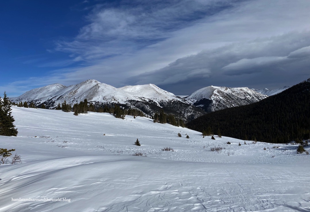
Don’t get me wrong; I still complain about 4:30pm sunsets and scraping ice off my car. But winter in the mountains… I love it so much! The combination of sharp rocky ridgelines and shimmering white landscape and treetops dusted with snow against the bright blue skies is ethereal. I’ve reached the point where I look forward to winter weekend adventures and I find myself eagerly awaiting the day there will be enough snow to go snowshoeing.

In early January 2021, that day finally arrived.
(But you’re reading this in April 2022 because it got buried in my drafts folder. Oops.)
Chelsea and I headed out on a Thursday morning for the Butler Gulch trailhead near Empire, Colorado. This is an area frequented by backcountry skiers, and the adjacent Jones Pass trail is popular among snowmobilers. However, the trail is open to hikers and snowshoers as well.
That being said, I don’t recommend visiting this trail on a winter weekend. At one point, I stepped to the edge of the trail to adjust my snowshoe and very nearly got run over by a skier who came flying around a curve at full speed and barely managed to stop in time. I imagine there are far more skiers on weekends, and I personally wouldn’t want to deal with the constant worry of getting run over.
Aside from that, this was a pretty great hike! We began at the winter parking area, which required a short walk up the road to the Butler Gulch trailhead. The road to the parking area was only semi-plowed and we were glad to have an AWD car.

This is a groomed path and we didn’t need microspikes or snowshoes through this section. It wasn’t until we approached tree line that the groomed path disappeared and it was time to break trail.


I always forget just how hard snowshoeing is. Even with snowshoes, we were sinking into the fresh powder. While the snow was hardened by wind in some places, in other places it was soft and fluffy. We both sunk in up to our hips at times, even with snowshoes.
After one particularly deep post hole, Chelsea realized that the softer sections were snow-covered bushes (as evidenced by the fact that her legs were now in the bushes). The wide-open views were gorgeous but eventually we reached the point of being too tired to push on any further despite the beckoning scenery.
(We also were careful to stay in the middle of the gulch, well away from the steep slopes full of fresh powder. It’s good that we were smart about this; there was a human-triggered avalanche nearby the very next day.)


During our hike, Chelsea mentioned that Bulter Gulch was also a pretty summer destination. So a few months later I found myself back at the trailhead, this time with my fiancé, excited to see wildflowers and the old mining remains that were completely buried in winter. It was a much easier trek with solid ground beneath our feet instead of snow. It’s still a steep hike, though, gaining about 1500 feet (455 m) in just a little over 2 miles (3.2 km).
As we climbed through the forest, I was surprised to find a beautiful creek cascading down the hillside. In fact, the trail crosses this creek multiple times. It was completely buried in the winter so I hadn’t seen it at all.


There were thousands of wildflowers as well. Dark purple monkshood was the prominent species down low in the forest. Once we reached tree line, the main species were various colors of Indian paintbrush and a yellow flower that I believe is part of the aster family.


And then there’s Butler Gulch itself and the loop trail through it. Most reviews recommend going counterclockwise around the loop so we heeded their instructions.
Admittedly, we completely missed the turnoff to go clockwise so it’s a good thing that wasn’t our plan. We did find the turnoff on the way back down – it’s marked by a small cairn – so if you’re specifically looking for it and/or using a GPS app to track your hike, it shouldn’t be too difficult to locate.

When traveling counterclockwise, the first things you’ll encounter are views and wildflowers and some small, hearty pine trees that manage to survive up here.


Next is the remains of the Jean Mine. There is old mining equipment all over the Colorado mountains and we’ve stumbled across pieces of it on a handful of other hikes. But this was one of the more intact collections of equipment, including a rusted out old truck, an ore cart, and some other items that we couldn’t identify. If anyone with some mining knowledge knows what these are, I’d love to learn!


There is no signage and it’s not a wilderness area, so we took that to mean it was okay to walk up to everything and look around. We kept in mind Leave No Trace, though, and didn’t touch or step on anything.
While researching to write this post, I learned that this is an old lead and zinc mine, which makes me think maybe we should have kept our distance. Oops.


Once looping around past the mine area, the trail ascends to a ridge behind the gulch. On a nicer day, we would have completed the loop and climbed to the high point. But not on this day. Most of the state was inundated with forest fire smoke from the west coast. Using smoke forecast maps, I’d found this small pocket of cleaner air at Butler Gulch.
It was the first blue sky we’d seen in about 3 days, and would remain the only blue sky we’d see for most of the next week. Since most of the scenery was obscured by smoke, we figured there was no point climbing to a view and not being able to see anything. Instead, we skipped the rest of the loop and headed back around the way we came.


As with most Colorado trails that I’ve hiked in both summer and winter, I have trouble deciding which season I liked better. I’ll let you all be the judge!
The Important Stuff:
- Getting there: from I-70, take exit 232 toward Berthoud Pass (US Highway 40); turn onto Jones Pass Road (just before the first hairpin turn) and proceed to the trailhead near the Henderson Mine.
- Fees and passes: none.
- Hiking: the entire loop trail is about 6.5 miles (10.5 km) with 1800 feet (550 m) of elevation gain.
- Where to stay: this hike is easily done as a day hike from the Front Range or any of the towns along I-70 in Clear Creek County.
- Other: while it is okay to explore the mining equipment, please don’t step on it, touch it, or sit in the old vehicles; they are fragile and easily damaged.
Leave a Reply to WanderingCanadiansCancel reply