Sometimes, you just need a break from reality for a few days. And what better way to escape than with a weekend in the mountains?
My fiance, our friend K, and I arrived at the trailhead around 8:00am Saturday morning and right off the bat, things got interesting. We were at the car, making final preparations, when I noticed movement in the trees about 15 feet (5 m) away.
Naturally, it was a moose.
I’ve lost count of the number of way-too-close moose sightings I’ve had in the last year. Suffice it to say it’s been far too many and I’m over it. Fortunately, the car was between us and the moose. He also couldn’t have cared less about us. He just kept munching away. Nonetheless, we hastily finished loading up our gear and set off, putting some much-needed space between him and us.

Our backpacking permit was for one night at Pine Marten Campsite, about 8 miles (12.9 km) up North Inlet Trail. North Inlet is an area that was very heavily impacted by the East Troublesome Fire that burned through the park in October 2020, scorching many thousands of acres. The first 3.5 miles (5.6 km) of the trail passes directly through the burn area.
It was both heartbreaking and interesting to observe this area up close. Interesting because I’d never seen such a recent aftermath of a forest fire; we could see and smell it everywhere. Heartbreaking because everything was blackened. A combination of drought and the many beetle-killed pine trees in Colorado means that forest fires burn hot, incinerating the landscape and sterilizing the soil.
However, it was also encouraging to see some early signs of recovery. Though less than a year had passed, some grasses and flowers were already growing back. The contrast between the black and green was striking.


Aside from the fire remnants, not a lot stands out about this first 3.5 miles (5.6 km). It’s a fairly easy hike with only about 400 feet (120 m) of elevation gain. We spotted a second moose grazing in one of the pockets of newly grown grass. And by the end of this stretch, we found ourselves at Cascade Falls.


We ate a snack here and then continued on, the landscape surrounding the trail now intermittently burned. In the unburned sections, we could see what the area had looked like before the fire; it was lush and green. And, as with most of Colorado, teeming with fungus thanks to the ridiculous amount of rain we received this year.
(The good news is that we are at least temporarily no longer in a drought.)
Some of the more bizarre fungi are pictured below. I don’t know their actual names, so I’ve captioned them with the names we made up based on their appearance.


Seven-point five miles (12 km) and about four hours after leaving the car, we reached the junction with the Lake Nokoni/Nanita Trail. The North Inlet Trail continues up to the Continental Divide. We, however, branched off toward the lakes. Our campsite – Pine Marten – was about 0.5 mile (0.8 km) up this trail on North Inlet Creek.
There are two sites at Pine Marten; we chose the second one. It was more open with better views, but with a slightly steeper path down to the creek as compared to site #1. Upon arrival, we encountered a deer. She regarded us cautiously for a couple minutes before moving on, and we didn’t see her again.


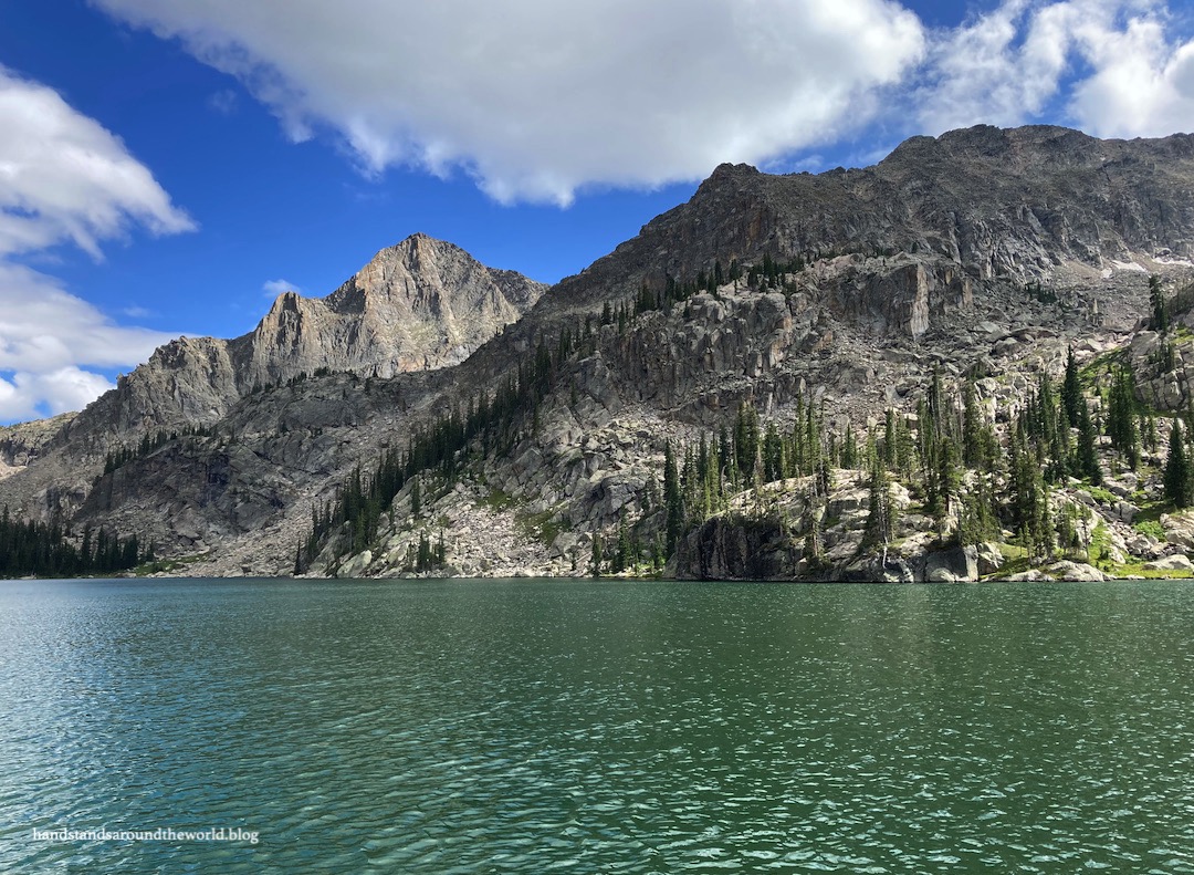
After eating lunch and setting up camp, we loaded up our day packs and continued up the trail toward Lake Nokoni and Lake Nanita. This was the steepest and most challenging part of the hike, made more tiring by the fact that we’d already hiked 8 miles (12.9 km) with a lot of weight on our backs. All three of us were struggling as we ascended the many switchbacks up to Lake Nokoni. But at long last we arrived, and it was absolutely worth the effort!


From Lake Nokoni, more elevation gain awaited us. We were not enthusiastic about this in the least… but we’d come this far so we were determined to press on to Lake Nanita. We followed the trail up the shoulder of Ptarmigan Mountain, over, and down into a bowl on the opposite side.


We were almost certain we’d get rained on given the never-ending parade of grey clouds, but the weather held off and by the time we departed Lake Nanita, the sun had returned. It did end up raining on us overnight, but by that point we were snuggled up in our sleeping bags staying warm and dry.
We woke to fast-moving clouds and spent the entire hike back to the car in alternating sun and shade. It was one of those days where I was taking my sunglasses on and off every five minutes.
Our hike ended with about a quarter mile (0.4 km) of uphill back to the car, which was absolutely the most brutal way to end a weekend in which we’d hiked 22 miles (35.4 km) and gained 3865 feet (1180 m) of elevation.
But we did it.
Another beautiful Rocky backpacking trip in the books!
The Important Stuff:
- Getting there: North Inlet Trailhead is at the east edge of Grand Lake; note that you do not go through the Kawuneeche entrance station to get here.
- Fees and passes: there is a $30/car daily or $35/car weekly entrance fee to RMNP; America the Beautiful passes are accepted. From May-Oct, if you arrive between 9:00am-2:00pm you will also need a timed entry permit to access this trailhead if you plan to day hike or a backcountry permit if you plan to backpack. Since you do not pass through an entrance station, both items should be displayed on your dashboard.
- Permits: backpacking in Rocky requires a backcountry permit. Permits can be reserved in advance (recommended, as they are highly competitive) or you can try your luck with a walk-up permit on the morning of your hike. Permits are site-specific and cost $36 (this is in addition to the park entry fee). There are multiple backcountry sites along the North Inlet Trail.
- Hiking: roundtrip distance to Lake Nokoni is 20 miles (32 km) with 3250 feet (990 m) of elevation gain; add 2.2 miles (3.5 km) and 600 feet (185 m) for Lake Nanita, for a total of 22.2 miles (35.7 km) and 3865 feet (1180 m) of elevation gain.
- Other: this would be an extremely long and challenging day hike and I would only recommend attempting it as such if you are fit and acclimated to the elevation. Start early and plan to spend the entire day on the trail; be sure to have adequate food, water, clothing, and a way to pack out any toilet paper (or buy a kula cloth).
For more information, see my posts on visiting Rocky Mountain National Park and backpacking.
Leave a Reply to WanderingCanadiansCancel reply