A vast majority of Colorado’s state parks are in the plains or foothills in the general vicinity of the main population centers. Many of them – especially the ones on the plains – are centered around bodies of water and geared toward water sports.
They’re also crowded. Because of these factors, most of these parks aren’t places we’re dying to visit. Especially in the summer when everyone else in Colorado is there too. But there are a handful of parks that are up in the mountains, further from the city. State Forest State Park is one of them.
As of 2020, Colorado State Park campgrounds are available by reservation only (not due to COVID, this change was already planned and is intended to be permanent). So I booked us a site at Crags Campground a few months in advance, thus securing a two-night visit at the end of July.
I’ve already regaled you with the tale of our Crags Campground experience, so I won’t say any more on that topic today. The focus of this post is going to be the rest of the state park – which was much more enjoyable than the campground.
The American Lakes Trailhead is only about a mile away from the campground so it was a quick, easy drive on Saturday morning. We arrived around 8:00am and had to park in the first overflow area; while not as overwhelmingly popular as hikes closer to town, the main lot and all the overflow areas did fill.
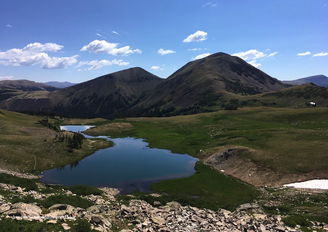
American Lakes – also known as the two Michigan Lakes plus Snow Lake (I don’t understand this naming scheme at all) – are located about 4.3 miles (6.9 km) up the American Lakes Trail. The first mile (1.6 km) of the trail is an old, rocky one-lane road that leads up to the Michigan Ditch, one of many diversion structures in Colorado that transport water from the west to the east side of the Continental Divide to provide an adequate amount for the cities and farms on the plains.
Once it reaches the ditch, the trail narrows and continues to climb. It meanders through forests and past a few small meadows before eventually opening up into a large basin at just over 11,000 feet (3350 m).
Behind us, we could see the Rawah Mountains. Down in a valley to the left, two moose were munching on willows. Lulu Mountain loomed above, rising nearly 1000 feet (305 m) above Thunder Pass. And up ahead was Michigan Lakes, framed by Static Peak and the very prominent and recognizable Nokhu Crags.


The first Michigan Lake is much smaller and shallower than the second. The two are connected by a short stream; it could really probably just be considered one lake. There must be lots of fish, because there were quite a few people fishing. It’s also a popular backpacking location.


Beyond Michigan Lakes is a 300 foot (90 m) rocky headwall, which you’ll have to climb if you want to see Snow Lake. We wanted to see Snow Lake, so up we went. It was slow going, steep, and required the use of our hands in a couple spots. But it was worth it for the chance to sit on the shore of Snow Lake, and also for the views of Michigan Lakes from above.


After a snack and some relaxing on the lake shore, we descended back to Michigan Lakes. But we weren’t done yet. Before heading back to the trailhead we detoured about 0.8 miles (1.3 km) south to Thunder Pass, which marks the boundary between State Forest State Park and Rocky Mountain National Park.


About a month earlier we had climbed Mount Ida, located along the Continental Divide in the heart of Rocky. From there, we’d gazed out into the distance at the Nokhu Crags. Here on Thunder Pass, with the Crags rising behind us, we had the chance to gaze back at Mount Ida.


It was lunch time now and the usual afternoon thunderstorms were approaching, so we began making our way back to the trailhead. After 10.1 miles (16.3 km) and 1920 feet (585 m) of elevation gain, our legs very much enjoyed the chance to do some sitting while we explored other parts of the park by road.
Our first stop was Ranger Lakes for a picnic lunch.


Next, we drove out to North Michigan Reservoir (I have no clue why so many things in this park are named Michigan).

We also stopped at the Beaver Ponds Overlook and walked a short stretch of trail along the water out to some beaver dams. Sadly, we did not see any beavers.

Our initial plan was to hike to Lake Agnes the following morning before heading home but, thanks to the moose and our early departure, we ended up doing a quick evening hike to Lake Agnes that same day instead. Our legs didn’t love that we were asking them to hike some more. But we forced them to do it anyway, and rewarded ourselves with the beers we’d intended to drink with dinner. There’s a first time for everything; this was definitely the first time I’d ever walked up a trail with a can of beer in my hand!
I also did the entire hike in tevas – the flip flop kind – which was less than ideal on such a rocky trail. But my hiking boots had given me multiple blisters and no amount of bandaids or moleskin could persuade me to cram my feet back into them.


Because it’s relatively accessible, many people consider Lake Agnes the main attraction of the park. It’s not difficult to see why it’s so well known. The hike wasn’t all that challenging and it’s a beautiful lake with a sizeable island in the middle and the Nokhu Crags rising sharply above the eastern shore. It was late in the day and another storm was approaching so we didn’t have time to walk the entire perimeter of the lake. The lighting in my photos also isn’t great thanks to the darkening grey sky.


And that wraps up our two days at State Forest State Park. It’s a place I’d definitely like to return to; it’s a pretty large park and we really only explored the southern section. The northern half can only be reached via lengthy gravel roads and, due to their length, most of the trails up there are more suited to backpacking than day hiking. A future weekend getaway, perhaps.
Maybe someday I’ll be able to write a State Forest State Park part 2 post. And if any of my Colorado readers have spent time here, I’d love to hear your recommendations for next time!
The Important Stuff
- Getting there: the main access to the park is from CO Highway 14 near the town of Walden; there are multiple entrance points that branch off from this main road.
- Fees and passes: there is $9/day fee to enter the park (unless you have a Keep Colorado Wild pass) in addition to a separate camping fee.
- Hiking: 8.6 miles (13.8 km) round trip to American Lakes, plus an additional 1.5 miles (2.4 km) to Thunder Pass; total 1920 feet (585 m) elevation gain. Lake Agnes is 1.6 miles (2.6 km) and 450 feet (135 m) round-trip.
- Where to stay: there are 5 developed campgrounds in the park, as well as yurts and dispersed camping sites; all charge a fee and require reservations. Backpacking is also allowed as long as park policies are adhered to.
- Other: if you’re visiting Colorado and hoping to see some moose, this is the place. We were here barely more than 24 hours and saw 6 of them. If you do see one, be sure to observe quietly and from a distance.
Leave a Reply