(Update: as of 2025, this trail is closed for construction. When it reopens, permits will be required.)
The title of this post was supposed to be “Colorado 14ers #2: Mount Sneffels” but, alas, the weather had a different set of plans. In fact, this post and the next two will be a three-part saga of a road trip that didn’t entirely go according to plan. The weather left a lot to be desired.
A lot.
The 5 days we’d set aside for this trip perfectly coincided with the worst 5 days of July.
Usually, rain in Colorado comes in the form of possible scattered afternoon thunderstorms that pass through in about 30 minutes. If only we’d been so lucky.
Anyway.
Mount Sneffels is located in the San Juan Mountains of southwestern Colorado. We spent some time in this area previously and completely fell in love with it. All of Colorado’s mountains are pretty, but the San Juans are our absolute favorite. Needless to say, this was a place we were eager to return to.
We had limited vacation time this past summer, so we opted to spend the days we did have on a jam-packed San Juans backpacking adventure that would take us to multiple brilliantly colored alpine lakes and – ideally – the summit of Mount Sneffels. As Sneffels was the most challenging of the planned hikes, this was our first destination.
There are multiple routes up Mount Sneffels; we opted for the longer and slightly less popular one through Blue Lakes Basin because (a) we wanted to see Blue Lakes and (b) our car can’t make it all the way up the road to the other trailhead. It’s about 15 miles (24 km) round-trip to the summit via this route, so we turned it into a backpacking excursion to make it more manageable.
The hike begins at the Blue Lakes Trailhead at the end of CO Road 7. It’s a bumpy 9 mile (14.5 km) dirt road, but most any car should be able to make it. This is a popular hike and I’ve heard that parking can be challenging. We didn’t have any issues finding a spot, but that may have been because of the poor weather.
This entire hike is within the Uncompahgre National Forest and enters into the Mount Sneffels Wilderness about 1.2 miles (1.9 km) in. At about the halfway point, we reached the first creek crossing. In drier weather, it would be easy to rock-hop across. In wet weather, it was not.
My fiance found some precarious-looking logs to cross while I pulled out my hiking poles and put the waterproof capabilities of my hiking boots to the test (spoiler alert: they passed with flying colors). I actually ended up relying heavily on this feature for the entire hike. This trail offers many things, but bridges is not one of them.

Eventually the trail emerges from the trees to some viewpoints. Supposedly. The low-hanging clouds made for some pretty limited views.


Most people who backpack this trail (and there are a lot of them) set up camp at Lower Blue Lake. There are plenty of established spaces. Whenever possible, it’s best to camp in a pre-existing spot rather than make your own, in order to contain the impact on the environment.

Our plan was to continue up toward Middle Blue Lake instead and find an established spot there. The middle lake is about 600 feet (185 m) and 0.6 miles (1 km) above the lower lake.


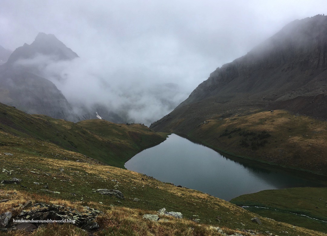
We set up camp not far below Middle Blue Lake, pitching our tent in an established spot in the trees about 30 seconds away from this view of the lower lake:


We went to bed early, hoping it would clear up overnight. But it was not to be. It started raining shortly after we got into the tent and didn’t stop for nearly 13 hours. By the time we dragged ourselves out of our sleeping bags the next morning, this was our view:

At one point, a couple hikers passed us and asked which mountain was Sneffels. I automatically pointed, and when I looked up I realized I was directing their attention to a wall of fog. For 24 hours we were literally at the base of the mountain and not once were we able to see it. If that doesn’t adequately sum up the horrible weather, then I’m not sure what will.
So we made the decision to abandon our Sneffels summit attempt. An already difficult climb was now going to be full of wet slippery rocks, and what’s the point of climbing a mountain and having no views? In the end, we hiked the final 15 minutes up to Middle and Upper Blue Lakes and then called it off, packing up our tent a day early and returning to the trailhead.
(Naturally, the day we headed back home would have been perfect for a summit attempt; not a cloud in the sky and no chance of thunderstorms. Frustrating to say the least.)


After an additional 12 hours of rain, the already challenging water crossings were even more precarious on the way back down. We were able to avoid crossing this:

But back on the main trail, the other two crossings couldn’t be avoided. The stream out of the lower lake was flowing so rapidly that the crossing we’d used the day before was impassable. Our only solution was to take off our shoes and stick our bare feet into the freezing cold lake water.


Back to the car a day early, we had to adjust our plans. Flexibility while traveling is something I’m not good at. I like to have a plan. I like to know where we will stay each night. It’s something I’m working on and, in that vein, I’d packed some contingency supplies for this trip just in case, including an air mattress that fits in the back of our car. This turned out to be a fortunate decision and allowed us to drive to our next planned hike and spend the night sleeping in the car at the trailhead.

And that’s where I’ll leave off for today. Part 2 of this saga – the one portion that mostly went according to plan – will be up next week. Until then, happy adventuring!
The Important Stuff:
- Getting there: the trailhead discussed here is located at the end of CO Route 7 near the town of Ridgway (not to be confused with the other Mount Sneffels trailhead at Yankee Boy Basin, or the multiple other Blue Lakes in Colorado).
- Fees and passes: none.
- Hiking: round-trip it is 6.4 miles (10.3 km) and 1600 feet (490 m) of elevation gain up to the lower lake, an additional 1.2 miles (2 km) and 600 feet (185 m) up to middle lake, and an additional 0.8 miles (1.3 km) and 200 feet (60 m) up to the upper lake (total: 8.4 miles/13.5 km and 2400 feet/730 m elevation gain to the upper lake and back).
- Where to stay: for those not looking to backpack, this is completely doable as a day hike; dispersed camping is allowed near the trailhead and the town of Ridgway is only about 30 minutes away and offers many lodging opportunities.
- Other: before setting out, I highly recommend calling the local forest service office and/or reading reviews on AllTrails for info on trail conditions; between the mud and the water crossings, we could not have completed this hike without waterproof boots and trekking poles.
Leave a Reply to DianaCancel reply