Obtaining a backcountry permit for Rocky requires similar levels of intensity as many Colorado hiking feats, including summiting a 14er or finding parking at a trailhead or snagging a front country campsite anywhere during the summer. Permits become available each year on March 1st at 8:00am MST.
So on March 1st at 7:59am, I was sitting in front of my laptop obsessively hitting the reload button until the “wilderness campsite reservation request” link appeared.
When we first moved here, I promised myself I’d never become that person who sets a reminder in her phone for permit applications or wakes up at 4:00am to go hiking.
Clearly it’s time for me to eat my words.
I’ve become that person, and it took a remarkably short period of time for this change to occur.
Anyway. We were fortunate enough to receive the permit we wanted, which was for the Thunder Lake campsite at the end of August. Thunder Lake is located 6.8 miles (10.9 km) and 2100 vertical feet (640 m) from the Wild Basin Trailhead in the southeastern portion of the park. This is a long day hike so turning it into an overnight trip was a perfect solution, and it also allowed us to spend the afternoon exploring the area and climbing up the unofficial trail to Lake of Many Winds and Boulder Grand Pass!
Wild Basin is a much more remote section of Rocky, meaning it’s substantially less crowded. However, the parking area is also substantially smaller. We arrived just after 7:00am on a Saturday and there were maybe 15 spots left at the Wild Basin trailhead. There are other parking areas back down the road but depending on where you can find a space it can add quite a bit of distance to an already lengthy hike.
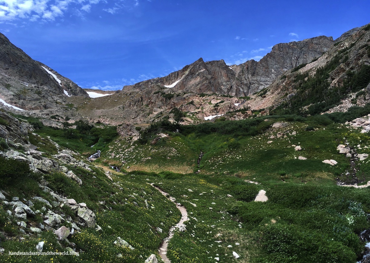
The trail to Thunder Lake itself is relatively unremarkable. We spent the entire hike in the trees with only a couple places where the forest opened up for any type of view. There are quite a few forks in the trail, all of which are well-signed. About 1.5 miles (2.4 km) from the trailhead is a junction; a bypass trail splits off to the right leading to multiple backcountry campsites while the main trail continues towards Calypso Cascade and Ouzel Falls – the two main destinations in Wild Basin.


We took the campsite trail on the way up and the main trail on the way down. The main trail is definitely prettier, but it was nice to cut 0.6 miles (1 km) from our uphill hike given that we had a lot of extra weight on our backs. Once we connected back up with the main trail, it was a slightly steeper 2 miles (3.2 km) to Thunder Lake. Overall, though, the elevation gain is spread out fairly evenly.
The biggest excitement of this part of the hike was coming around a curve to find a badger standing in the middle of the trail staring at us. I’d never seen a badger before, and my initial reaction was panic that it was a skunk or even a wolverine before the reasonable part of my brain kicked in and informed me that those were clearly the facial markings of a badger.
He stared at us for a few moments before deciding we weren’t worth the trouble and scampering off down the trail and into the rocks. I wish I’d had the presence of mind to grab my camera but, alas, I was too busy worrying about being sprayed by a skunk.
We reached our campsite turnoff – about 0.2 miles (0.3 km) short of Thunder Lake – in approximately 3 hours. Trails to the individual campsites are marked by red arrowheads on trees and the sites themselves are marked by a silver arrowhead on a pole.
The instructions are to camp as close as possible to the arrowhead but safely away from standing dead trees. This can, admittedly, be difficult in some places as there are a lot of dead trees in Colorado forests thanks to the pine bark beetle epidemic. There were two established tent pads in our site that were about as far away from dead trees as we could possibly get.
The closest dead tree was pretty hefty; though it could have easily crushed us to death, our only real choice was to bank on the fact that it was large and sturdy enough that it was unlikely to be blown over. Seeing as I’m sitting here writing this, we can safely assume it stayed standing despite the fairly constant wind.


We really enjoyed our site; there were plenty of logs and rocks for sitting, the nearby creek was a perfect water source, and we were far enough from the two neighboring sites that we could just barely glimpse their tents through the trees. My only complaints are the mosquitoes and the fact that the soil is so fine that the wind gusts picked it up and blew it right under our rainfly and through the screen into our tent.
After setting up camp, we packed our lunches, water, and layers and headed up to Thunder Lake and beyond. It was windy at the lake but we found a fairly secluded little gravel “beach” to sit and enjoy our lunch.

The trail unofficially continues around to the right of the lake, winding along the shore through the trees to the western edge of the water. It crosses the inlet stream and shortly reaches tree line. The wildflowers were unbelievable despite the fact that it was the end of August. Everything in the mountains was about a month behind in 2019 thanks to the endless winter.


Beyond timberline, the trail begins to climb. A lot.
From Thunder Lake to Lake of Many Winds is 1.3 miles (2.1 km) and 1300 feet (400 m) of elevation gain, most of which is in the latter section of the hike. There was a lot of huffing and puffing involved and I wasn’t sure I was going to make it, especially when the valley we thought was our destination wasn’t and we were forced to accept that we still had to climb up to the next valley if we wanted to see the lake.
This final push up to Lake of Many Winds was extremely steep but the wildflowers, ptarmigans, marmots, pikas, and views kept me going.


Lake of Many Winds lives up to its name. The wind was whipping down from the Continental Divide above us and seemingly blowing in multiple directions at once. Coupled with the occasional strong gusts coming up the valley and lifting a layer of mist from the surface of the water, this was a chilly destination. We managed to find some shelter amongst the giant boulders where we could enjoy the beauty and solitude without being blown away.


From here, Boulder Grand Pass on the Continental Divide looms above, a low spot between Tanima Peak and Mount Alice. We could see the talus and scree we’d have to navigate to reach the pass and debated with ourselves after watching some trail runners pick their way down the slippery rock. But it was early afternoon and the skies were blue, so we decided to go for it.
There’s no trail but the path is intuitive; aim for the gully to the right of the snowfield and you will eventually make it up to the divide. I found the talus to be much easier to navigate than the scree, which was so steep and unstable that it felt like we were walking on sand. At one point, the ground under both of my feet started sliding down the mountain; fortunately, it stopped before I ended up caught in a rockslide.


It was slow going. It took us 30 minutes to travel the 0.15 miles (0.25 km) and 400 vertical feet (120 m) from the lake to the pass. And, as expected at an elevation of 12,100 feet (3690 m), we were battling ridiculous winds… so strong, in fact, that my attempts at a handstand were a complete failure.


The pass itself is broad and we found ourselves surrounded by an expanse of alpine tundra and with views in all directions! To the east we could see all the way down Wild Basin to the Colorado plains. To the west was Grand Lake. North and South were the mountains of the Continental Divide.

We hung out on the summit for a while, taking photos and chatting with another cross country hiker before beginning the careful descent back to Lake of Many Winds and Thunder Lake. Now that we were looking down into Wild Basin, we spotted Falcon Lake nestled in a small valley off to our left!

We ended up back at Thunder Lake that evening to watch the sunset before collapsing into our tent, exhausted. We’d hiked 9.6 miles (15.5 km) miles and gained 3600 vertical feet (1100 m), and we still had a 7 mile (11.3 km) hike back to the car to look forward to the next morning.

But not before returning to Thunder Lake just after sunrise for a beautiful breakfast!

The Important Stuff:
- Getting there: the Wild Basin trailhead is located at the southeast entrance to Rocky off Highway 7 near Allenspark; follow the brown signs to Wild Basin.
- Fees and passes: there is a $30/car daily or $35/car weekly entrance fee to RMNP; America the Beautiful passes are accepted. From May-Oct, if you arrive between 9:00am-2:00pm you will also need a timed entry permit to access this trailhead if you plan to day hike or a backcountry permit if you plan to backpack.
- Permits: backpacking in Rocky requires a backcountry permit. Permits can be reserved in advance (recommended, as they are highly competitive) or you can try your luck with a walk-up permit on the morning of your hike. Permits are site-specific and cost $36 (this is in addition to the park entry fee).
- Hiking: round-trip distance to Thunder Lake is 13.6 miles (22 km) and 2100 feet (640 m) elevation gain; add 2.6 miles (4.2 km) and 1300 feet (400 m) round-trip to Lake of Many Winds and 0.3 miles (0.5 km) and 400 feet (120 m) round-trip to Boulder Grand Pass.
- Other: hard-sided bear canisters are REQUIRED for all overnight stays in Rocky. Canisters should contain all food, toiletries, sunscreen, garbage, and any other scented items except DEET, must be closed all the way when not in use, and be placed at least 70 adult steps away from your tent when you’re not at your site.
For more information, see my posts on visiting Rocky Mountain National Park and backpacking
Leave a Reply