
Historically, I’ve wrapped up each year with a summary of our annual highlights. I’m going to do the same this year, but with a little twist. In 2019, for the first time ever, I participated in the 52 Hike Challenge. This is exactly what it sounds like: the challenge of completing 52 hikes in 52 weeks. The only guidelines are that the hike should be at least 1 mile (1.6 km) long, you can complete a maximum of 1 hike per day (on the few days I did multiple hikes, I lumped the mileage together and counted it as 1 hike), and repeat hikes are acceptable.
I ended the year with 63 hikes totaling 304.9 miles (491 km) and 61,312 feet (18,688 m) elevation gain, marking a successful completion of the challenge. So, as a summary of 2019, I’ve decided to post 1 photo from each hike. A handful of these hikes were completed twice, which is why the numbering on the list below doesn’t match the total number of hikes listed above.
NOTE: I don’t live track my hikes, so distances and elevation gains are from trail signs, maps, or AllTrails, and may not be exact.
- Palisade Falls + Grotto Falls, Hyalite Canyon, Montana | 5 miles (8 km) | 515 feet (160 m) elevation gain

- Tower/Castle/Walkers Dream Loop, Mount Falcon Park, Colorado | 3.5 miles (5.6 km) | 640 feet (195 m) elevation gain

- Golden Cliffs Loop, North Table Mountain Park, Colorado | 2.5 miles (4 km) | 600 feet (185 m) elevation gain

- Snowshoe Trail, Brainard Lake Recreation Area, Colorado | 6 miles (9.6 km) | 500 feet (150 m) elevation gain

- Mayflower Gulch, White River National Forest, Colorado | 5 miles (8 km) | 1000 feet (305 m) elevation gain

- Mills Lake/Loch Vale, Rocky Mountain National Park, Colorado | 4.8-6.8 miles (7.7-10.9 km) depending on route | 1250 feet (380 m) elevation gain | completed twice

- Nymph/Dream/Emerald Lakes, Rocky Mountain National Park, Colorado | 3.6 miles (5.8 km) | 705 feet (215 m) elevation gain | completed twice

- Lake Haiyaha, Rocky Mountain National Park, Colorado | 4.4 miles (7.1 km) | 840 feet (255 m) elevation gain | completed twice

- Sand Canyon Trail, Red Rock Canyon Open Space, Colorado | 2 miles (3.2 km) | 420 feet (130 m) elevation gain

- Evergreen Mountain Loop, Alderfer/Three Sisters Park, Colorado | 6.8 miles (10.9 km) | 1070 feet (325 m) elevation gain

- Mountain Lion Trail, Golden Gate Canyon State Park, Colorado | 6.8 miles (10.9 km) | 1585 feet (485 m) elevation gain

- Eldorado Canyon Trail, Eldorado Canyon State Park, Colorado | 6.5 miles (10.5 km) | 1945 feet (595 m) elevation gain | completed twice

- Wetlands Trail, Clear Creek Natural Area, Texas | 3 miles (4.8 km) | 60 feet (18 m) elevation gain

- Maxwell Falls Trail, Arapaho National Forest, Colorado | 3 miles (4.8 km) | 515 feet (155 m) elevation gain

- Chief Mountain, Arapaho National Forest, Colorado | 4 miles (6.4 km) | 985 feet (300 m) elevation gain

- Pope Trail, Cherry Creek State Park, Colorado | 1.9 miles (3.1 km) | 50 feet (15 m) elevation gain | completed twice

- Sykes Mountain + Sullivan’s Knob, Bighorn Canyon National Recreation Area, Wyoming/Montana | 6 miles (9.7 km) | 990 feet (300 m) elevation gain

- Bergen Peak, Elk Meadow Park, Colorado | 10 miles (16 km) | 2280 feet (695 m) elevation gain

- Royal Arch, Chautauqua Park, Colorado | 3.4 miles (5.5 km) | 1490 feet (455 m) | completed twice

- Garden of the Gods, Colorado Springs, Colorado | hiked 2 different sections on 2 different days for a total of 6.5 miles (10.5 km) | 450 feet (135 m) elevation gain

- Crater Rim + Crater Vent + Lava Flow Trails, Capulin Volcano National Monument, New Mexico | 2.4 miles (3.9 km) | 465 feet (140 m) elevation gain

- Forsythe Canyon Trail, Arapaho National Forest, Colorado | 3 miles (4.8 km) | 480 feet (145 m) elevation gain

- Mount Sanitas, Boulder, Colorado | 3.2 miles (5.1 km) | 1255 feet (380 m) elevation gain

- Browns Creek Falls + Colorado Trail, San Isabel National Forest, Colorado | 8 miles (12.9 km) | 1020 feet (310 m) elevation gain | completed as a 2 day backpacking trip, which counts as 2 separate hikes

- Mills/Jewel/Black Lakes, Rocky Mountain National Park, Colorado | 11 miles (17.7 km) | 1640 feet (500 m) elevation gain

- Gem Lake + Sprague Lake, Rocky Mountain National Park, Colorado | 4.1 miles (6.6 km) | 1020 feet (310 m) elevation gain

- Chasm Lake, Rocky Mountain National Park, Colorado | 8.4 miles (13.5 km) | 2600 feet (790 m) elevation gain

- Mount Sniktau, Arapaho National Forest, Colorado | 3.5 miles (5.6 km) | 1530 feet (465 m) elevation gain

- Soda Creek Trail, Keystone, Colorado | 2 miles (3.2 km) | 100 feet (30 m) elevation gain

- Cliff Palace + Balcony House + Soda Canyon + Petroglyph Point, Mesa Verde National Park, Colorado | 4.7 miles (7.6 km) | 685 feet (210 m) elevation gain

- Long House Loop + Step House + Cedar Farm Loop + Far View Sites, Mesa Verde National Park, Colorado | 6.5 miles (10.5 km) | 595 feet (180 m) elevation gain

- Bridal Veil Falls, Telluride, Colorado | 2.4 miles (3.9 km) | 850 feet (260 m) elevation gain

- Ouray Perimeter Trail, Ouray, Colorado | 5.8 miles (9.3 km) | 1510 feet (460 m) elevation gain

- Sprague Lake + Adams Falls + Alberta Falls, Rocky Mountain National Park, Colorado | 2.9 miles (4.7 km) | 330 feet (100 m) elevation gain

- Turret Arch/The Windows + Double Arch, Arches National Park, Utah | 1.5 miles (2.4 km) | 200 feet (60 m) elevation gain

- Fiery Furnace + Landscape Arch + Sand Dune/Tapestry/Broken Arches, Arches National Park, Utah | 5.7 miles (9.2 km) | 995 feet (305 m) elevation gain

- Crater Lake, Maroon Bells-Snowmass Wilderness, Colorado | 3.6 miles (5.8 km) | 690 feet (210 m) elevation gain

- Exclamation Point, Black Canyon of the Gunnison National Park, Colorado | 3 miles (4.8 km) | 365 feet (110 m) elevation gain

- Warner Point, Black Canyon of the Gunnison National Park, Colorado | 1.5 miles (2.4 km) | 405 feet (125 m) elevation gain

- Pine Creek Trail + Dillon Pinnacles, Curecanti National Recreation Area, Colorado | 5.5 miles (8.9 km) | 770 feet (235 m) elevation gain

- North Tenmile Creek Trail, White River National Forest, Colorado | 6.8 miles (10.9 km) | 890 feet (270 m) elevation gain

- Mount Chapin, Rocky Mountain National Park, Colorado | 3.9 miles (6.3 km) | 1465 feet (445 m) elevation gain

- Thunder Lake/Lake of Many Winds/Boulder Grand Pass, Rocky Mountain National Park, Colorado | 16.6 miles (26.7 km) | 3750 feet (1145 m) elevation gain | completed as a 2 day backpacking trip, which counts as 2 separate hikes

- Medicine Bow Peak, Snowy Range Scenic Byway, Wyoming | 7 miles (11.3 km) | 1710 feet (520 m) elevation gain

- Square Top Lakes, Guanella Pass, Colorado | 4.3 miles (6.9 km) | 920 feet (280 m) elevation gain

- Helms Lake, Guanella Pass, Colorado | 12 miles (19.3 km) | 2405 feet (735 m) elevation gain

- Eccles Pass, Eagles Nest Wilderness, Colorado | 10.2 miles (16.4 km) | 2960 feet (900 m) elevation gain | also… the place where this happened!!!

- Upslope Backcountry Taproom, Winter Park, Colorado | 5 miles (8 km) | 500 feet (150 m) elevation gain

- Wild Loop + Blue Sky Loop, Devil’s Backbone Open Space, Colorado | 7.3 miles (11.7 km) | 715 feet (220 m) elevation gain

- Bierstadt Lake + Sprague Lake, Rocky Mountain National Park, Colorado | 4 miles (6.4 km) | 655 feet (200 m) elevation gain

- Spruce Mountain Loop, Spruce Mountain Open Space, Colorado | 5.5 miles (8.9 km) | 565 feet (170 m) elevation gain

- Panorama Point + Independence Mountain, Evergreen, Colorado | 4.3 miles (6.9 km) | 1410 feet (430 m) elevation gain

- Eagle’s View Loop Trail, Reynolds Ranch Park, Colorado | 5.6 miles (9 km) | 1100 feet (335 m) elevation gain

- Cedar Gulch Trail to Galbraith Loop, Mount Galbraith Park, Colorado | 4.1 miles (6.6 km) | 930 feet (285 m) elevation gain

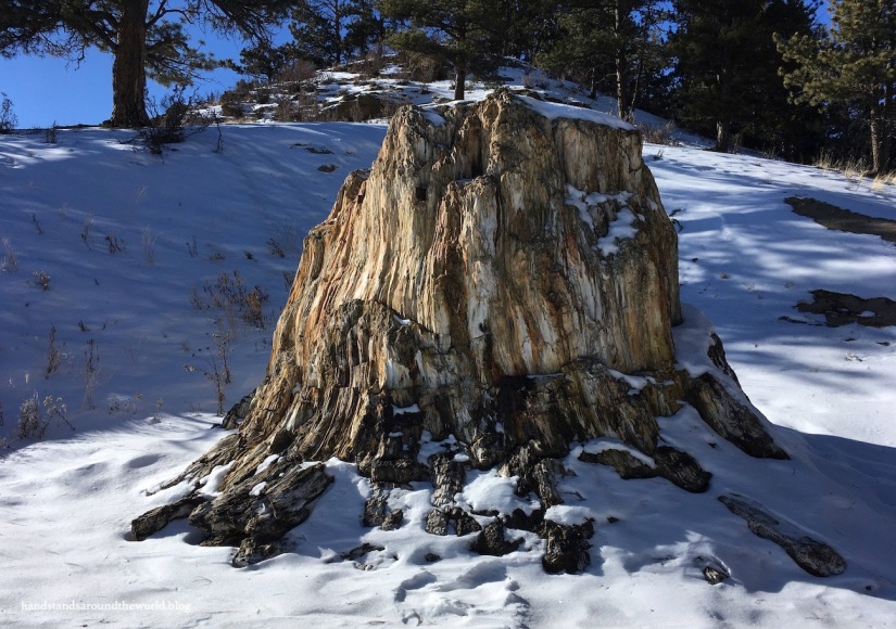
- Petrified Forest Loop, Florissant Fossil Beds National Monument, Colorado | 1 mile (1.6 km) | 80 feet (25 m) elevation gain

What a great achievement! I was thinking there’s no way I could do this, but if the minimum is a mile… maybe I could! lol (after all I walk more than that home from work every day!)
LikeLiked by 1 person
You can totally do it! Urban trails count too so depending on the options near you, you could even do it without traveling too far from home.
LikeLike
What an awesome goal!! Thinking about how I can incorporate a challenge like this into my life!
LikeLiked by 1 person
Maybe 52 days outside? 52 walks? Some other random number of hikes? Lots of possibilities!
LikeLike
What an amazing year and an equally amazing challenge! Congratulations all ’round! Mel
LikeLiked by 1 person
Thank you!
LikeLiked by 1 person
Congratulations! What an impressive list of hikes.
LikeLiked by 1 person
Thanks!
LikeLike
Congrats on rocking the 52 Hikes Challenge! This challenge sounds like it is great motivation to get out on the trail and spend more time outdoors. I think I might attempt this for 2020. I already have 1 hike done! And congrats on the engagement! I’m sure that makes this challenge even more memorable for you.
LikeLiked by 1 person
It’s such good motivation, and a lot of fun! And thank you!!
LikeLiked by 1 person
The 52 Hike Challenge sounds like a great way to expand your hiking horizons and explore some new trails 🙂 I especially like the snowy scenes, and the reflections in #26. Congratulations on your engagement, and hope 2020 is off to a good start for you!
LikeLiked by 1 person
Thank you! Happy New Year 🙂
LikeLiked by 1 person
Great post! You completed a lot of really amazing hikes!! Beautiful pictures, and congrats on your engagement!! ❤
LikeLike
Thanks so much! The challenge was definitely a motivator to get out there and hike in lots of new places!
LikeLike
Fantastic photos and recap! Congratulations and best wishes for more adventures in 2020!
LikeLiked by 1 person
Thank you!
LikeLike
Congrats on completing your challenge. I used to do that in NC with the NC 100 challenge,100 miles on the trails of NC….. but I usually hit about 300 miles in a year. Here in Texas time and distance makes it harder to find trails without repeating some of them over and over. I am in a Texas hiking Facebook group that has a 1000 mile challenge………………..
LikeLike
Oooh 1000 miles is a lot! That would be pretty impressive to accomplish though! You should join the 52 hike challenge, it’s free and anyone can do it!
LikeLike
Great post Mike. The stats are awesome, photos breathtaking but the joy you must have in breathing in all those wonders would take volumes to express I bet.
LikeLiked by 1 person
I went to a lot of amazing places for sure!
LikeLike
Great job with the challenge!
LikeLiked by 1 person
Awesomeness!
LikeLiked by 1 person
Thanks!
LikeLiked by 1 person
Congratulations Diana! That’s an awesome challenge. I’m drawn to the beautiful winter scenes, especially #28.
Happy New Year! Wishing you lots of fun hiking and travel adventures.
LikeLiked by 1 person
Thank you! It’s funny that you mention #28 because it was actually a gorgeous sunny day in July that we did that hike… although it still looked very much like winter at that elevation!
LikeLike
Love it! What’s next for 2020?
LikeLiked by 1 person
Not entirely sure. I’m not going to do the 52 hike challenge again this year because I want to focus a little less on hiking and expand my adventure horizons (paddleboarding, maybe some kayaking, XC skiing are my ideas so far). But we definitely still have plans to camp and hike and do some backpacking!
LikeLiked by 1 person
That sounds awesome!
LikeLiked by 1 person