The next morning we woke to blue skies, the fog of the previous afternoon long gone. This was excellent news for us as we were headed up to the northeast section of the park to catch our first glimpses of the mountain.
From Ohanapecosh, we drove north to the White River entrance. Five miles (8 km) in, the road forks; left leads to White River ranger station and campground and right leads to the Sunrise area of the park. We went left.
From the White River Campground, we followed the Glacier Basin trail; about a mile up, it intersects with the 1 mile (1.6 km) Emmons Moraine trail, which leads to an overlook of Emmons Glacier.


After arriving back at White River, we took a break for lunch and then headed back to the fork in the road. This time, we went right. It’s a 10 mile (16 km) drive on a fairly curvy road to get to Sunrise.
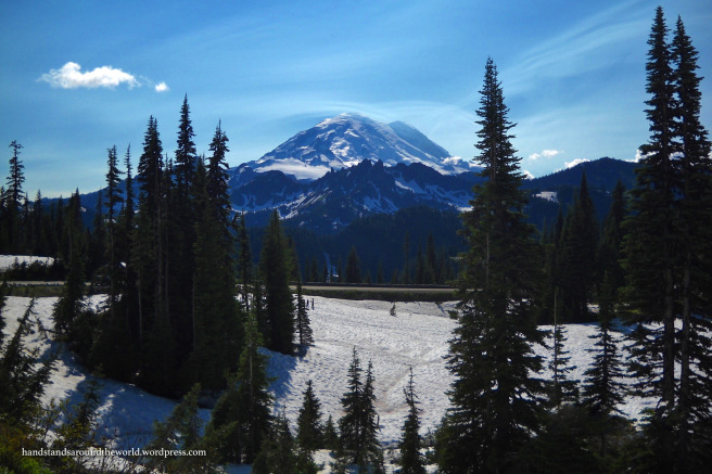
Just past the halfway point, we found ourselves at a high point overlooking Sunrise Ridge and Sunrise Lake. The road makes a precarious hairpin turn here; there’s a large pullout with a view of the lake down below in one direction and Mount Rainier in the other. The mountaintop was still in the clouds on our way in, but by the time we headed out for the day, the sky was nice and clear!


After touring the Sunrise Visitor Center, located at the end of the road, we took the Shadow Lake trail south from the parking lot to Emmons Vista. From there, we connected up with the Wonderland trail which took us to Shadow Lake.
It was only 3 miles (4.8 km) round trip to Shadow Lake, and not an overly difficult hike. The views of Rainier were spectacular, and we saw a black bear near the trail… definitely a successful hike!
One thing to keep in mind is that the elevation at Sunrise is about 6400 feet (1950 m). The lake still had a bit of snow, despite the fact that it was late July, and wildflowers don’t reach their peak here until late summer.


Sadly, it was then time to head back to Ohanapecosh for the night. We could easily have spent an entire week just in the Sunrise area and not have hiked all the trails. There are just so many things to see at Rainier. Unfortunately, real life dictated that my mom could only take so many days off of work, so we only had 1 day in this area. All the more reason for me to come back someday!


The Important Stuff:
- Getting there: Sunrise is the northeast section of the park, located off WA Highway 410.
- Fees & passes: $30 per car for a 7-day pass – card only, or pay online in advance. America the Beautiful passes are accepted. Timed entry reservations may be required for some areas of the park.
- Camping: There are multiple campgrounds in Mount Rainier; some accept reservations while others are first-come-first-serve.
- Hiking: See a complete list of hiking trails in the park here.
- Other: Sunrise is the highest elevation area of the park, so snow persists well into July and temperatures are cool even in the summer.
Leave a Reply to klffCancel reply