Hopefully you guys aren’t sick of reading about Yellowstone yet, because we still have this post and one more to complete our tour of the park. Last week, I left off at Upper Geyser Basin, home to the famous Old Faithful as well as dozens of other geysers and hot springs.
The majority of Yellowstone’s geothermal features are in the western half of the park, and have therefore been the focus of my posts so far. This week, we begin making our way east. There will still be some geothermal features sprinkled in, but they aren’t the main attractions in the eastern half of the park. Instead, it’s all about lakes, waterfalls, and canyons.
On the map below, this post will cover the rest of the Lower Loop of Grand Loop Road, spanning 54 miles (87 km) from Old Faithful on the lower left to Canyon Village, located approximately in the center, where the Upper and Lower Loop Roads converge.

Table of contents
Kepler Cascades & Craig Pass
Departing Upper Geyser Basin and heading east, Grand Loop Road begins to climb. More specifically, it ascends about 1000 feet (305 m) in 7.5 miles (12 km) to the Continental Divide. It then drops down and ascends once more, crossing the Divide a second time.
The first crossing, at 8262 feet (2518 m), is Craig Pass. This is not the type of pass that’s laden with views, though. It’s surrounded by trees and a pond filled with lily pads. The second crossing is similar, minus the pond.

In between these two high points is Shoshone Lake Overlook. Shoshone Lake is the largest backcountry lake in Yellowstone and can only be reached on foot or by boat; unless you feel like hiking or canoeing many miles, this will be your only view of this lake. On a clear day, the Teton Mountains are visible from here as well.

I’ve gotten a little ahead of myself here, though, because I’ve completely skipped over Kepler Cascades. On the way up Craig Pass is a pullout on the right with a short walk out to a viewpoint of these cascades on the Firehole River. A word of warning: if you don’t like heights, you may not like this viewing platform. It’s a long way down.

Pit toilets can be found at most of these pullouts, as well as at each of the three picnic areas along this stretch of road. However, there are no campgrounds or other amenities here.
West Thumb
As Grand Loop Road descends from the Continental Divide for the second time, it travels around two large curves. As you round the second one, Yellowstone Lake comes into view. Yellowstone Lake is the largest lake in the park and one of the largest high altitude lakes in North America, with a surface elevation of 7733 feet (2357 m).
As large as the lake looks from here, you’re only seeing a very small portion of it: a finger that extends to the west, accurately called the West Thumb.
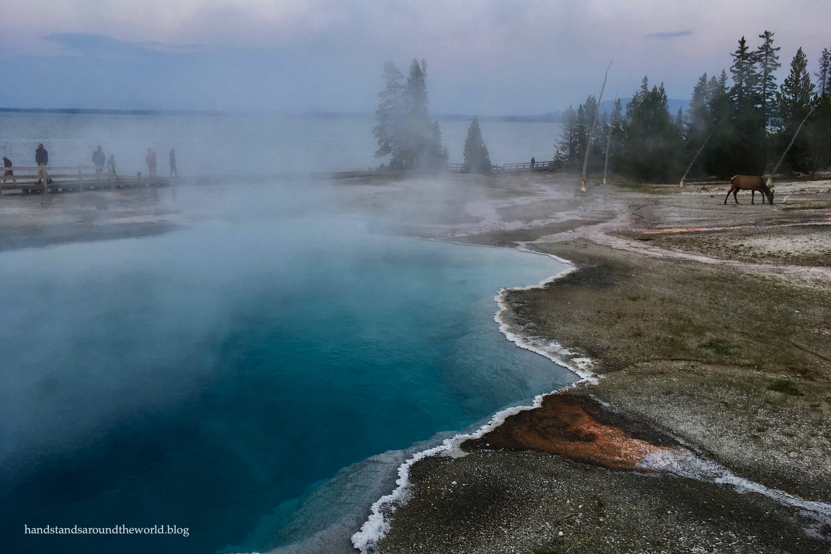
The main attraction at West Thumb, right on the shore of Yellowstone Lake, is the small but pretty West Thumb Geyser Basin. To my knowledge, there are no longer any active geysers at this basin. However, it’s home to numerous beautifully-colored hot springs.


I really love West Thumb; the contrast of the colorful hot springs against the backdrop of Yellowstone Lake is so lovely. Despite the lack of geysers, it’s probably my favorite basin in the entire park.

Camping, picnicking, lodging, visitor centers (passport stamps at both locations!), and other amenities can be found at West Thumb, as well as at Grant Village, located a couple miles south along the road to Yellowstone’s South Entrance.
Yellowstone Lake
Beyond West Thumb, Grand Loop Road parallels the western shore of Yellowstone Lake for 21 miles (34 km). At times, there will be trees between you and the lake. However, there are many pullouts and four picnic areas that provide access to the lakeshore. In particular, Gull Point Drive is a worthwhile one-way loop.


Over the years, I’ve spent a few nights at Bridge Bay Campground. It’s a nice place to stay, albeit cool and damp due to its elevation and proximity to such a large body of water.

A visitor center (with passport stamp), lodging, and amenities can be found at the northern end of this stretch of road at Lake Village.

There’s a second campground and additional amenities (including a visitor center with a passport stamp) at Fishing Bridge. Note that due to past problems with grizzly bears, Fishing Bridge allows hard-sided camp units only. Tents and soft-sided pop-out trailers are not allowed.
Lastly, even if I’m not staying at Fishing Bridge, I always like to stop at the actual bridge over the Yellowstone River, as it emerges from Yellowstone Lake. This is the headwaters of the Yellowstone River – the river we will be following for the remainder of this Yellowstone journey.
Fishing is no longer allowed from the bridge, but it’s a nice view.

Mud Volcano
There’s only 16 miles (26 km) remaining to reach Canyon Village, but this is a 16 miles with a lot of bang for its buck. The first stop is LeHardys Rapids, an area of the Yellowstone River marked by – you guessed it – a collection of rapids. From the parking area, a path meanders along the river’s edge to a viewing platform.

I’d mentioned in a previous post that Artists Paintpots – an area of colorful mudpots – wasn’t really worth a visit because there are better ones elsewhere in the park. One of those locations was Fountain Paintpot, mentioned previously. The other is here at Mud Volcano.
Mudpots form when the thermophilic (heat-loving) bacteria living in a hot spring produce sulfuric acid, which erodes the surrounding rock. As the rock crumbles into the boiling water and dissolves, it thickens the hotsprings into bubbling pools of mud.
If you’re not keen on the sulfurous scents of Yellowstone, you may want to plug your nose as you climb out of the car, because you’re about to be assaulted by the smell of rotten eggs. The hydrogen sulfide gas that’s released from the mudpots makes this one of the most odorous areas of the park.
Lest that deter you from visiting, I assure you, it’s well worth the smell.
(There’s a sentence I’ve never said before.)
A fairly easy 0.8 mile (1.2 km) loop of boardwalks and trails weaves through this geothermal basin, leading to vigorously bubbling mudpots of varying viscosities. Though it’s small and smelly, it’s an area I really like. There’s nothing quite like the gurgles and plops of boiling mud.


Right: Mud Volcano
As a bonus, on our most recent visit to Mud Volcano, a handful of bison were hanging out amidst the mudpots.


Hayden Valley
Next, Grand Loop Road enters the Hayden Valley – one of the best places in the park to view wildlife. Over the years, I’ve seen elk, bison, bears, bald eagles, and an otter here (although I’m not sure the otter counts, as it was being eaten by a grizzly bear).


One thing to note: though the distance is short, it’s not unusual for it to take an hour or more to travel through the Hayden Valley. Between stopping to view wildlife and stopping while wildlife crosses the road (we once got stuck for 45 minutes while an entire heard of bison made their way across…), it’s often very slow going.
I bring this up because beyond Mud Volcano, there are no bathrooms, water spigots, or picnic areas until Canyon Village. Be sure you have plenty of water and snacks before you set off.

Canyon Village
The Canyon Village area is home to the Grand Canyon of the Yellowstone River, which is my favorite part of the entire park – meaning I have a lot to say and far too many photos to share. Given how long this post already is, I’m going to save that information for the next post.
But first, because I can’t help myself: one of my favorite photos of the canyon.

Up next: Yellowstone National Park, part V: Canyon Village to Mammoth
Leave a Reply to RosieCancel reply