Located on the southwest edge of the Denver Metro area, Deer Creek Canyon Park is open to hikers, bikers, and equestrians. The park isn’t huge, but there are 14 miles (22.5 km) of trails, including routes to the park’s two highest points: Plymouth Mountain and Bill Couch Mountain. There’s also a lengthy trail connecting this park to the adjacent Hildebrand Ranch park.
My husband and I first visited Deer Creek Canyon a few years back, a reluctant compromise after having to cancel our long weekend road trip due to COVID. In the years since, I’ve returned to the park two other times and I’ve now hiked almost all the trails. Therefore, it seemed appropriate to return to this post from years ago and update it to encompass all these hikes.

Table of contents
Bill Couch Mountain
Our first hike in Deer Creek Canyon was to the 7082 foot (2159 m) summit of Bill Couch Mountain.
This hike can be done as an out-and-back or it can be made into a lollipop loop. We opted for the loop. From the parking lot (GPS address is 13388 Grizzly Drive), most people seemed to be heading up the shorter but steeper Plymouth Creek Trail, so we chose the gentler and more meandering Meadowlark Trail instead.
This trail weaves northward up a hillside, a gradual but steady incline, before turning and heading south. The very last section of trail drops down to Plymouth Creek and terminates at the Plymouth Creek Trail.


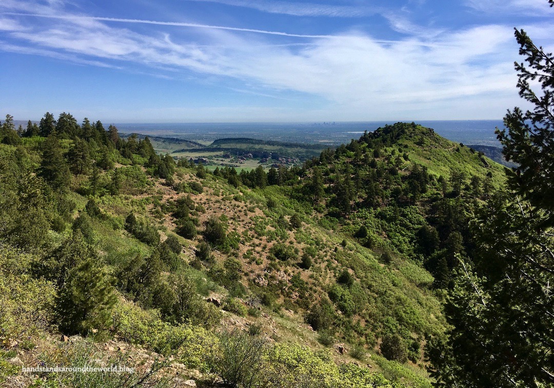
From here, we turned right and followed the Plymouth Creek Trail for the next mile. The trail parallels the creek – as the name suggests – and gains a decent amount of elevation fairly quickly. Eventually it flattens out, curves around, crosses the creek, and comes to an end.
On this particular day, the trail also passed by two rattlesnakes. Thankfully, they were off to the side and left us alone.

From the end of the Plymouth Creek Trail, it was a quick jaunt on the Red Mesa Loop and then 0.5 miles (0.8 km) on the Golden Eagle Trail to reach the summit of Bill Couch Mountain. We found all the junctions to be well-marked, though the signs only list the trail name and not the name of the mountain, so you’ll want to have a map to help you navigate the junctions.

Upon arrival, we were surprised but pleased to have the summit entirely to ourselves. This close to the city, it’s rare to have anything to yourself.
As with many Colorado summits, the high point is a jumble of rocks which provided a nice place to sit and enjoy the views. With everyone working from home, smog levels were greatly reduced and we had a nice view of downtown Denver. The surrounding landscape was painted numerous shades of green and the sky was blue; it was a beautiful day!


Initially we’d considered taking a 1.6 mile (2.6 km) round-trip detour up Plymouth Mountain on our way back, but ultimately decided to save that one for another day. Instead, we headed back to the car, opting to stay on Plymouth Creek Trail the whole way back.


Deer Creek Canyon actually suffered a small forest fire in August 2019. Fortunately, firefighters were able to contain it within a couple days and it only burned about 25 acres.
Remarkably, we saw very few signs of the fire just 9 months later. A few blackened trees and heartier plants remained, and some small burned patches of soil were still bare, but I was amazed at how much vegetation had already returned 9 months later. It was an interesting juxtaposition, and a reminder of both the destructive power and strong resilience of mother nature.

Hike stats: as a loop, 6 miles (9.6 km) with 1315 feet (400 m) of elevation gain.
Plymouth Mountain
Our next visit to Deer Creek Canyon Park was in the winter, which meant we got to experience the park beneath a layer of snow. This time, we headed up Plymouth Creek Trail to Plymouth Mountain Trail, which encircles the mountain at an elevation of about 7000 feet (2135 m). On the south side, a trail branches off and ascends the remaining 300 feet (90 m) to the summit.


It was a fairly gradual walk through the forest until the final section, which required a bit of scrambling to stand on the true summit. However, if you’re not up for scrambling there are plenty of wide open spaces to sit and enjoy the view without climbing the rocks.


We walked the other half of the Plymouth Mountain Loop on the descent and retraced our steps along Plymouth Creek Trail back to the car. It was not a difficult hike overall, though it’s always a little more challenging with snow and we did use our microspikes for traction.
If you’re trying to decide between these two options, personally I would choose Bill Couch Mountain over Plymouth Mountain, as the former has more wide open summit views.
Hike stats: 6.35 miles (10.2 km) with 1460 feet (445 m) of elevation gain for the full loop.
Black Bear Trail
Despite being on the edge of the city, there are in fact black bears in Deer Creek Canyon, so the name of this trail is not as far-fetched as it might seem. We didn’t encounter any, thankfully, but we did see signs warning that recent hikers had.
A couple years ago, there were also a handful of mountain lion sightings in the park. So, basically, be prepared for wild animal encounters: observe your surroundings, make noise so they hear you coming, and keep your dogs on a leash.
Anyway.
My most recent foray into Deer Creek Canyon was just last month, when I met up with Chelsea for a one-way hike beginning at the Deer Creek Canyon trailhead but ending a few miles down the road at Hildebrand Ranch Park. For this hike, we would need two cars.
We met at Hildebrand Ranch, left her car there, and then drove my car up to Deer Creek Canyon Park. From here, we set off on the Plymouth Creek-to-Plymouth Mountain Trail route I described above. This time, however, we did not summit the mountain nor did we loop all the way around it. Instead, we took the back (southwest) half of the loop and then branched off onto the Black Bear Trail.
(Note that this trail is closed from February 1-July 31 each year to protect important golden eagle nesting habitat.)

At this junction, numerous signs warn of what lies ahead: a 6.3 mile (10.1 km) trail with no escape route. There’s also no shade. It’s not a hike I’d want to do in the heat of summer.
We were feeling good and the weather was good, so we committed to the challenge. It was mostly downhill for the next 2.5 miles (4 km) as we dropped down the slopes of Plymouth Mountain toward the park boundary.


From here, the trail enters a 1 mile (1.6 km) easement that squeezes between parcels of private land and connects the two parks. It was surrounded on both sides by tall fencing; far from the most scenic stretch of trail. We also noticed more than one array of cameras watching us as we passed by. I’m not sure if there have been issues in the past or if there are just some paranoid homeowners.

This brought us to the end of the downhill hiking (for now) and into Hildebrand Ranch Park. The defining feature of Hildebrand Ranch Park is two parallel hogbacks – which we now had to climb.


The trail began its ascent, and we saw this sign and began to wonder what we’d gotten ourselves into.

Actually, it wasn’t that bad, though if you’re not a fan of heights or exposure, you probably won’t enjoy it.
(And I definitely would not ride a bike on it.)


Neither of us, as it turns out, had looked at the topo map of this trail quite as closely as we should have. We’d been trying to figure out how it was still so many miles to the trailhead when we just had to go up and over the hogback. Then we reached the top and saw the second – and much larger – one.
Oh. Well, that explained it.

So down we went, and then up one final time. Though the section between these hogbacks wasn’t the most exciting thing in the world, I did like that they blocked out most of the surroundings. We were just a couple miles from the nearest houses and not much further from the edge of a very large metropolitan area… and we couldn’t hear or see any of it!

From the top of the second hogback, it was a zigzaggy hike back down to the plains, and then a mostly flat walk along the base of the hogback to the trailhead.

After dropping our packs in the car, we meandered over to the old barn near the parking lot. Unfortunately, there are no windows, so other than walking the perimeter, there wasn’t much to see here.

But that was fine; our legs were very tired. So we hopped in her car, retrieved my car from the starting trailhead, and went our separate ways.
Black Bear Trail: complete!
Hike stats: 11.5 miles (18.5 km) with 1830 feet (560 m) of elevation gain.
Up next: a roadtrip to Nebraska!
Leave a Reply to The Travel ArchitectCancel reply