When I was a kid, there were a couple girls in my school whose families would head to Moab, Utah every single year for spring break.
I never really understood the allure of returning to the same place over and over again when there are so many other things to see, but in retrospect that was because (a) I wasn’t old enough to realize the way some places manage to capture your soul and never let go, and (b) I’d never been to Moab.
Now I have. Multiple times. And while Arches National Park will never be able to overtake my love for mountains, it’s an undeniably cool place.
Over the course of multiple visits, I’ve gotten to know the park pretty well. In this post, I’ll pass along everything I’ve learned, provide more details on hiking and camping in the park, and share a few a lot of photos.
Table of Contents
- Visiting the park
- Camping
- Viewpoints
- Hiking
- The Windows
- Wolfe Ranch and Delicate Arch
- Fiery Furnace
- Devils Garden arches
- Devils Garden Loop
- Outlying sites
- Stargazing at Arches
- Weather and safety

Visiting the park
Arches National Park is in eastern Utah, with its single entrance station just off Highway 191, approximately 5 miles (8 km) north of Moab. Moab is also the basecamp for Canyonlands National Park, Dead Horse Point State Park, and all the surrounding BLM land. With so many recreation opportunities, expect the town to be pretty crowded year-round. Given its location in the desert, winter months aren’t entirely considered the off-season, though crowds should be a little lighter from November-March.
Due to overcrowding, Arches has recently implemented a timed entry system designed to address parking shortages, delays, and a line at the entrance station so long that cars were backed up onto the highway. From April through early July and the end of August through October, entry to Arches National Park between the hours of 7:00am-4:00pm requires advanced purchase of a timed-entry ticket. This ticket grants park entry during a one-hour window on your chosen date. One you’re in, you may exit and re-enter for the rest of the day.
The majority of timed entry tickets are available roughly six months in advance at 8:00am MDT, while a few will be released at 7:00pm MDT the night before. Tickets cost $2. If you have a reservation for camping, backpacking, or a ranger-guided tour, this will count as your timed-entry ticket for the day(s) of the reservation. Alternately, you can enter the park outside those hours without a ticket.
During the rest of the year no timed entry is required, but the park may temporarily close the entrance station if parking lots fill. It’s always best to get an early start.
No matter how or when you enter the park, an entrance fee ($30/car for a 7-day pass) or America the Beautiful pass is required. This can be paid in-person at the entrance station or purchased online in advance.
Be sure to have a digital or printed copy of your ticket available, as well as photo ID and your entrance fee or pass. If no one is at the entrance station, you’ll need to display printed copies of your tickets and/or passes on your dashboard.
Camping in Arches
There is only one campground in the park, and it’s one of my favorites! Devils Garden Campground is located at the end of the park road, about 18 miles (29 km) from the entrance station. Due to the narrow road and slower speed limits, expect the drive to take at least 35 minutes.
Devils Garden Campground has 51 sites, all available by reservation only from March through October and first-come-first-serve the rest of the year. Sites are $25 per night. It’s the desert, so water is limited; there’s drinking water and flush toilets, but no showers or hookups. For those, you’ll have to stay in Moab (but note that not all campgrounds in Moab offer these amenities either; here is a list of public showers in Moab).


Viewpoints
Once inside the park, the first stop is the visitor center. This is a great place to learn about the fascinating geology of the park. It’s also a good place to use the bathroom and fill water bottles; there are a handful of bathrooms beyond this point (most are pit toilets), and the only other water is at the very end of the park road.
Arches is one of the more accessible national parks, with some of the arches and other features visible without leaving the car or with just a short walk. I’ll talk more about hiking in a bit, but for now we’ll tour the first few viewpoints.

After ascending above the visitor center in a series of switchbacks (photo above), the road flattens and curves around to the first stop at Park Avenue. Named for (I think) Park Avenue in New York City, this is a wash lined with tall red rock walls.

A 1 mile (1.6 km) trail travels through it to Courthouse Towers on the other end, or you can just keep driving and view Courthouse Towers from the road. This collection of rocks includes The Organ, Tower of Babel, and the Three Gossips.


Between these two attractions is La Sal Mountains Viewpoint. On our most recent visit, we arrived just in time for sunrise and I captured one of my favorite photos from the entire trip!

Arches National Park is made almost entirely of sandstone, which forms when layers of sand are deposited and subsequently exposed to heat and pressure, causing them to harden. Sandstone is a relatively soft rock and highly prone to erosion, though the different layers erode at different speeds. Over thousands of years, water and wind have shaped the sandstone at Arches into towers, fins, and – obviously – arches. There’s also a viewpoint of some petrified sand dunes!

At just over 9 miles (14.5 km), and visible from the road, is the aptly-named Balanced Rock. A picnic area and bathrooms can be found here, the first ones since departing the visitor center. An easy 0.3 mile (0.5 km) trail encircles Balanced Rock.

Hiking at Arches
Beyond this point, at least some amount of walking or hiking will be involved to see most of the arches. Most of the trails are rated easy to moderate, though they may contain stairs, sand, and slickrock. On the slickrock sections, trails may be marked with rock cairns.
Off the slickrock, much of the ground at Arches is made of cryptobiotic crust, a living soil composed of microorganisms. The crust is recognizable by its popcorn-like structure, and is an important component of the desert ecosystem. This cryptobiotic crust is fragile and easily damaged by footsteps, so it’s extra important to stay on the trails when hiking in Arches.

Some of the slickrock trails may also pass by circular depressions called potholes. While the potholes are dry most of the year, they collect water during spring and summer and become their own little ecosystem. Insects, frogs, and other small animals call these potholes home. Some of these animals lay eggs in the potholes, which will hatch once the rains come the following year. It’s important to avoid stepping in the potholes as well, even when they’re dry.

Lastly, note that pets are not allowed on any trails in Arches.
The Windows
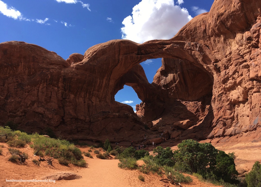
Just beyond Balanced Rock, the road forks; to the right is The Windows, the first of three concentrated areas of arches. The road leads to the trailheads for The Windows, Turret Arch, and my favorite arch in the park: Double Arch!
The Windows and Turret Arch can be reached on a 1 mile (1.6 km) roundtrip trail with about 100 feet (30 m) of elevation gain. The first portion is wheelchair accessible.


The Double Arch trail departs from the opposite side of the parking area; roundtrip distance is 0.6 miles (1 km).

Wolfe Ranch and Delicate Arch
Back on the main road, pass a short turnoff to Panorama Point en route to the final junction.

From here, a right turn will take you toward the most famous sight in Utah: Delicate Arch. This is by far the most popular area of the park; expect the parking lot to be full by 7:00-8:00am during peak season and be prepared for crowds at the arch. There’s usually a pretty long line for photos.
(Don’t be fooled by the picture below; I strategically lined up the shot to avoid capturing the 50+ people standing in line in front of us.)

A drive to the end of the road will bring you to the lower and upper Delicate Arch Viewpoints. While the arch is visible from here, it’s far away.

To hike up to the base of the arch, park at Wolfe Ranch and follow the 4 mile (6.4 km) roundtrip trail up to the arch. The elevation gain is approximately 550 feet (165 m) and the trail includes slickrock and a section along a somewhat narrow edge.
More information and photos of the trail and arch can be found here.
Fiery Furnace
Back on the main road once more, we’re on the final stretch to the end. The road passes by Salt Valley Overlook just prior to the parking lot for the Fiery Furnace.

The Fiery Furnace hike can only be completed with a permit for either individual entry or a ranger-guided tour. We opted for the tour, and I highly recommend it. The group wasn’t terribly large, we learned a lot from our guide, and, best of all, we didn’t have to navigate, nor did we have to worry about getting lost in this maze of red rocks.


As you can see, navigating the Fiery Furnace requires some narrow passageways, scrambling, and a few ledges. We found it to be a lot of fun. If you’re not comfortable with these things, though, this may not be a good hike for you. However, it’s nothing too extreme; my claustrophobic and acrophobic sister really enjoyed the hike.
Tickets sell out in advance so you’ll need to plan ahead, but I promise, it’s totally worth the cost. More photos from our Fiery Furnace tour can be found here.
Devils Garden Arches
And finally, we’ve reached the Devils Garden section of the park, all the way at the end of the road. First up is Sand Dune Arch, which is just 0.2 miles (0.3 km) from the road down a flat, sandy path.

Just up the road is a very short trail to Skyline Arch. However, if you’re staying at the campground, you can also walk to the arch from there. I believe there’s even a view of it from some of the campsites.

Also departing from the campground is a loop trail to Broken and Tapestry Arches. Traveling counterclockwise brought us to Tapestry Arch first. Tapestry Arch is unique because there’s a rock wall behind it, so you can’t really see through it.


Back in 2010, during my first visit to Arches with my family, we hiked to Broken and Tapestry Arches and my mom snapped photos of my sister and me at each one. During our 2019 trip, we decided to recreate these photos… except we didn’t have copies of either one with us, so we tried to do it from memory.
We were not quite successful, but we did get some good laughs out of it.


We had a 50% chance of getting this one right… so naturally, we stood on the wrong side of each other
We also got some laughs out of this candid photo my husband snapped of us at Broken Arch. It’s almost like we’re related or something, but I don’t really see the resemblance…

Devils Garden Loop
The longest hike in the park is the Devils Garden Loop, a 9 mile (14.2 km) lollipop loop that leads to multiple arches and other features. Most people only go as far as Landscape Arch which, with its 290 foot (88 m) span, is the fifth longest arch in the world. Roundtrip distance is 1.8 miles (3 km) with just 40 feet (12 m) of elevation gain. At the very least, it’s worth hiking to this point.

Beyond this point, this becomes a hike that takes some commitment, as well as the willingness to do some navigating, cross a lot of slickrock, and do some scrambling (and possibly some butt-scooting). It’s definitely not for everyone, but if you’re willing to tackle it, it’s worth the effort.


More information and photos from this hike can be found here.
Outlying sites
Due to its small size and relative lack of roads and trails, there aren’t a lot of options for getting off the beaten path in Arches. However, if you’re looking to escape the crowds and see things most visitors never do, there are a couple options.
A rocky, sandy road branches off at Balanced Rock and travels 8 miles (12.9 km) through Salt Valley to the trailhead for Tower Arch. From there, it’s a short hike out to the arch. Unfortunately, both a park ranger and a couple guys who had just driven the road warned against taking our Subaru down it so, for now at least, Tower Arch remains unseen.
Lastly, right on the southern border of the park, accessible from Highway 191, is the Courthouse Wash Rock Art Panel. This panel of pictographs is estimated to be between 2000-4000 years old, while the petroglyphs on the boulder beneath are from about 700 years ago. To reach the panel, park at the Moab Bike Path pullout along Highway 191. Follow the path a short distance, then branch off onto a trail and follow signs up to the panel. Please do not touch the rock art; the oils in our skin accelerate the decay of the colors and erosion of the rocks.


Stargazing at Arches
Arches has been an International Dark Sky Park since 2019. On our recent trip, we decided to take advantage of this and headed up to Courthouse Towers after dark. Though our viewing was occasionally interrupted by headlights (Panorama Point would be a better location as it’s further off the main road), it was among the best stargazing experiences we’ve ever had. There were thousands of stars, the Milky Way was prominent, Jupiter was unexpectedly bright, and we even saw a handful of meteors!


Weather and safety
Despite its popularity and proximity to Moab, Arches is pretty remote and proper precautions are necessary to avoid getting caught in a bad situation. Once you’re in the park, phone service will be limited to non-existent and GPS apps may have limited reliability in narrow canyons.
There is no gas, food, or any other amenities inside the park, either, so be sure your tank is full and you have everything you need.
There are also very few bathroom facilities and even fewer water spigots beyond the visitor center, so pack lots of extra water. Bring more than you think you need; during our summer visits to Arches, we were drinking nearly a gallon per person per day and still struggling to stay hydrated. Even in the offseason when it’s not so hot, hydration is a challenge. Never set out on any hike, no matter how short, without water and electrolytes.

Be prepared for exposure to the elements, too. Despite its desert location, Arches sits at an elevation of 4500-5500 feet (1370-1675 m). The sun is more intense, and the air is drier and contains less oxygen than you may be used to. At this elevation, sunburns, dehydration, and exertion happen much more quickly. Even in the winter when it’s cold, the air is still very dry.
Lastly, weather changes quickly here, particularly in the summer with the arrival of afternoon thunderstorms. Out on a trail in Arches is not a good place to be when weather rolls in; there aren’t a lot of safe places to take shelter from the snow, rain, wind, or lightning. Thankfully we’ve never been caught here in a thunderstorm, but we did get caught in a windstorm once. Despite hiding out behind some boulders until the worst of the gusts passed, we spent the rest of the day picking sand out of our mouths and ears.
Moral of the story: some advanced planning is necessary to ensure a safe and enjoyable trip to Arches. But it’s an incredibly unique park that’s absolutely worth a visit!
Leave a Reply to ThebeerchaserCancel reply